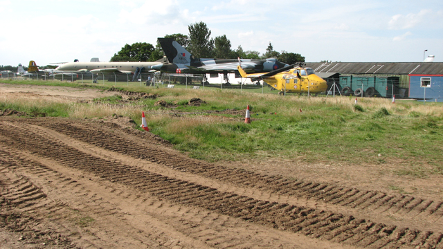
TG2114 : The City of Norwich Aviation Museum
taken 8 years ago, near to Norwich Airport, Norfolk, England
Work for the Northern Distributor Road (NDR) - which has since been renamed the Broadland Northway - started on 4 January 2016, with preliminary work including the clearance of vegetation, archaeology, utility service diversions and some drainage lagoon excavations, to be continued in 2016. Along the route there will be nine roundabouts and nine main structures including an overpass taking the A140 (Cromer Road) over the NDR. Slip roads connecting to the dual carriageway via two roundabouts will have to be constructed, along with six bridges, one taking the NDR over the Marriotts Way long distance footpath, another at Bell Farm and over the A140 road, Buxton Road, Newman Road and Middle Road. Two bridges will carry the NDR over the Norwich to Sheringham railway line and Plumstead Road, south of Rackheath.
Once complete, the 20km (12.5 miles) dual carriageway, running from the A47 road at Postwick to the A1067 Fakenham Road, is predicted to take thousands of vehicles a day off "unsuitable" roads in and around Norwich, but some people doubt whether the road will have the desired effect. Supporters say that it will be a shot in the arm for the economy and reduce rat-running, whereas critics fear it will increase traffic and pollution while causing swathes of countryside to be concreted over. The £178.5m project is expected to be complete in early 2018, and indeed its last section was opened on time, in the morning of 17 April. The new road has been assigned the number A1270.
For more detailed information read: Link
To see all pictures on a map go to > Link
Update: By October 2019, previously identified roosts of barbastelle bats, one of the rarest bat species in the UK seem to have disappeared in the vicinity of Felthorpe and Rackheath, with attempts to trap bats in those areas failing to land any female barbastelles and only one male specimen. Opponents of the mooted Northern Distributor Road Western Link had previously criticised the council for deciding a preferred route before bat surveys in the area were complete. The owner of a wood located on the proposed route had a Freedom Of Information request to Norfolk County Council for details of those surveys refused. (EDP, 18 October 2019)
 Map © Crown Copyright")
- Grid Square
- TG2114, 69 images (more nearby 🔍)
- Photographer
- Evelyn Simak (more nearby)
- Date Taken
- Saturday, 23 July, 2016 (more nearby)
- Submitted
- Sunday, 24 July, 2016
- Subject Location
-
OSGB36:
 TG 2151 1416 [10m precision]
WGS84: 52:40.7897N 1:16.5261E - Camera Location
-
OSGB36: TG 2154 1414
- View Direction
- Northwest (about 315 degrees)