2016
NT7809 : The Scottish Cheviots above Hind Hope
taken 8 years ago, near to Nether Hindhope, Scottish Borders, Scotland
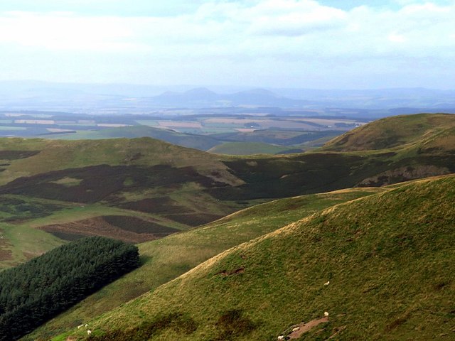
The Scottish Cheviots above Hind Hope
View towards the Eildon Hills from the ridge below Brownhart Moor. Just east of the Eildon Hills, near Newstead, was the Roman Fort of Trimontium. It was an advance post of the Romans in their province of Valenti NT5634 : Monument marking site of Roman Fort of Trimontium
This is a possible site to which messages could have been passed from the proposed Roman Signal Station located close to the location of this photo on the Roman Road of Dere Street, just below Brownhart Law NT7909 : Location of Roman Signal Station, Brownhart Law. Trimontium also lies on Dere Street, on route to Edinburgh, and is some 20 miles distant. Messages, however sent over these distances, could possibly have been relayed via the Roman Signal Station located on Eildon Hill North NT5532 : Eildon Mid Hill and Eildon Hill North. Another possibility is signalling to Ruber's Law in the west.
On Hadrian's Wall, the Romans had clever signalling systems based on letters sent by two groups of five flags. They also had a coded system, with which they could send only one of a dozen fixed messages, depending on the time for which they showed a flag or fire signal at night Link
There is a similar view here: NT5634 : Monument marking site of Roman Fort of Trimontium
 Map © Crown Copyright")
TIP: Click the map for more Large scale mapping
- Grid Square
- NT7809, 20 images (more nearby 🔍)
- Photographer
- Andrew Curtis (more nearby)
- Date Taken
- Friday, 23 September, 2016 (more nearby)
- Submitted
- Saturday, 24 September, 2016
- Subject Location
-
OSGB36:
 NT 7860 0989 [10m precision]
WGS84: 55:22.9506N 2:20.3581W - Camera Location
-
OSGB36: NT 78998 09627
- View Direction
- Northwest (about 315 degrees)