SH5571 : Menai Suspension Bridge
taken 10 years ago, near to Menai Bridge, Isle of Anglesey/Sir Ynys Mon, Wales
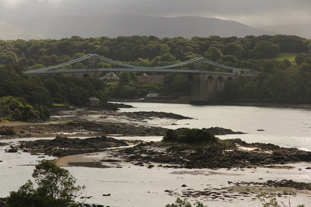
Designed by Thomas Telford and completed in 1826, it was the only road link between Anglesey and the mainland (and an essential component of the London - Holyhead route, with its onward links to Ireland) until the completion of the road deck on the nearby Pont Britannia in 1980. One requirement was that it should have sufficient clearance above the water to allow high masted Royal Navy ships to pass through at high tide.
The towers were built of limestone from which were suspended 16 wrought iron chains cables. Over the years it has undergone various changes to be able to handle greater loads, including the replacement of the chain cables with steel ones in 1938-40.
Although long distance traffic now uses the Pont Britannia, the bridge still serves an important role in linking Menai Bridge with Bangor.
Grade I listed - see Link.
The Menai Strait (Welsh: Afon Menai, the "River Menai") is a narrow stretch of shallow tidal water about 25 km long, which separates the island of Anglesey from the mainland of Wales.
The strait is bridged in two places the main A5 road is carried over the strait by Thomas Telford's suspension bridge, the first of its kind, opened in January 1826, and adjacent to this is Robert Stephenson's 1850 Britannia Tubular Bridge. Between the two bridge crossings there is a small island in the middle of the strait, Ynys Gorad Goch, on which are built a house and outbuildings and around which are the significant remains of fish traps, no longer used.
The differential tides at the two ends of the strait cause very strong currents to flow in both directions through the strait at different times, creating dangerous conditions. One of the most dangerous areas of the strait is known as the Swellies (or Swillies Welsh Pwll Ceris) between the two bridges. Here rocks near the surface cause over-falls and local whirlpools, which can be of considerable danger in themselves and cause small boats to founder on the rocks.
Wikipedia: Link
 Map © Crown Copyright")
- Grid Square
- SH5571, 727 images (more nearby 🔍)
- Photographer
- Richard Croft (more nearby)
- Date Taken
- Sunday, 17 August, 2014 (more nearby)
- Submitted
- Friday, 7 October, 2016
- Subject Location
-
OSGB36:
 SH 5562 7144 [10m precision]
WGS84: 53:13.2202N 4:9.8367W - Camera Location
-
OSGB36: SH 5431 7173
- View Direction
- East-southeast (about 112 degrees)