2016
SD3439 : Poulton-le-Fylde War Memorial: Names from WW2
taken 8 years ago, near to Poulton-le-Fylde, Lancashire, England
This is 1 of 3 images, with title starting with Poulton-le-Fylde War Memorial: Names in this square
Poulton-le-Fylde War Memorial: Names from WW2
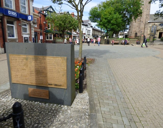
Poulton-le-Fylde War Memorial SD3439 : Poulton-le-Fylde War Memorial in the Market Place was originally erected in Queens Square in 1921. When the one-way traffic system was proposed the memorial was moved on 1st August 1979 to its present location in Market Place.
A stone behind the memorial has plaques giving the names of those who died in WW2:
Walter Ardern; Keith Bamber; Richard T Bamber; Norman Baron; Richard Bibby; Alfred V Brown; David Burt; William H Carlsson; John B Chadburn; William Cookson; James Croft; Reginald S N Fowler; Alfred J C Haines; Edward K Heywood; Richard Hodgkinson; Peter Hunter; Harold R Keeton; Lewis Kelly; Terence Lendrum; Joseph Martindale; Roy McCaffery; Harry McKeown; John Merrick; Bernard Pennington; John Perry; Robert G Rainford; Herbert Robinson; Herbert J Royle; George V Simson; George Smith; Joseph B Spencer; Richard Strother; Walter I Strother; James G Swain; Richard Thompson; Stanlet Tooze; James Varley; Philip A Walker; Thomas W Waring; Kenneth H Warlow; Harold Wikeley; Henry Beesley; Clifford Jackson; Robert Sutton; William Thornley.
 Map © Crown Copyright")
TIP: Click the map for more Large scale mapping
- Grid Square
- SD3439, 171 images (more nearby 🔍)
- Photographer
- Gerald England (more nearby)
- Date Taken
- Saturday, 27 August, 2016 (more nearby)
- Submitted
- Sunday, 23 October, 2016
- Subject Location
-
OSGB36:
 SD 3480 3939 [10m precision]
WGS84: 53:50.7983N 2:59.5498W - Camera Location
-
OSGB36: SD 3480 3939
- View Direction
- North-northwest (about 337 degrees)