TF3672 : Woodman's Cottage
taken 17 years ago, near to Harrington, Lincolnshire, England
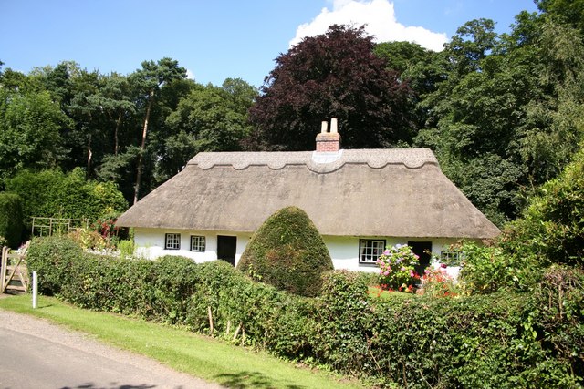
Mud & Stud is a construction technique found almost exclusively in Lincolnshire, where the timber frame has nailed, vertical laths between the studs. The mud of earth mixed with chopped straw and water is applied in layers and lime wash containing fat or oil seals the exterior. Link
The timber frame is usually of oak, though later examples are increasingly of pine, imported from the Baltic through Boston, with laths of Ash.
Though the term applies to a construction method, there is a distinctive vernacular style to cottages built this way - over 70% have a central chimney stack, most have a central door and baffle entry, a half-hipped thatched roof is traditional and no exterior timber framing is revealed. Many have been encased in a brick skin and the thatch replaced with pantiles or corrugated iron.
Hundreds of mud & stud buildings have been lost, though around 500 survive, around half are grade II and II* listed.
 Map © Crown Copyright")
- Grid Square
- TF3672, 16 images (more nearby 🔍)
- Photographer
- Richard Croft (more nearby)
- Date Taken
- Tuesday, 31 July, 2007 (more nearby)
- Submitted
- Friday, 10 August, 2007
- Subject Location
-
OSGB36:
 TF 360 720 [100m precision]
WGS84: 53:13.6843N 0:2.2060E - Camera Location
-
OSGB36: TF 360 720
- View Direction
- North-northwest (about 337 degrees)