NS3674 : Timber ponds and Finlaystone Point
taken 7 years ago, near to Langbank, Renfrewshire, Scotland
Port Glasgow has been a ship building town since 1780 when Thomas McGill opened a yard here. 18th Century shipbuilding demanded a lot of timber and Port Glasgow was a major timber importer during this time. Massive shipments of prepared and unprepared timber were received from far flung places such as Canada, Norway and the Baltic states. Vast timber holding ponds were constructed to the east of Newark Castle, stretching three miles along the coast, beyond Parklea, to Langbank. These are still very much in evidence today and can be seen from land, sea and air. They are known locally as "the stabs".
There were also timber ponds in the west end of the town, but these were removed as the shipyards expanded and no trace remains today. The map of 1864 shows the "Kingston Sawmill", "timber yard" and "timber ponds" on the site where the Kingston shipyard later stood. That area is now a housing estate, with some light industry at Ardgowan Street.
The twenty or so surviving timber ponds stretch from just west of Kelburn Park in the east end of Port Glasgow to near the A8 railway bridge at Langbank.
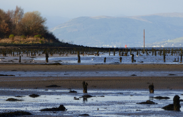
They are not really ponds in the traditional sense in that they do not hold water. They can be more accurately described as intertidal enclosures which are dry at low tide and flooded at high tide. The enclosures are mostly square in shape, their boundaries formed by lines of tall wooden stakes (known locally as "stabs") which are buried deep in the mud. It was within these enclosures that rafts of timber were stored.
As shipbuilding made the switch from timber to metal, the ponds fell into disuse and decline in the early part of the 20th Century.
Most of the area of the surviving timber ponds is within the Inner Clyde Nature Reserve which is managed by the RSPB, whose web site Linkdescribes it as follows - "The reserve contains internationally important numbers of wintering redshank and curlew that flock to the reserves rich mudflats, which are an important feeding ground. Other birds that can be found regularly on the reserve include lapwings, eiders, cormorants, scaups, goldeneyes, oystercatchers and breeding reed buntings and snipe".
Be careful if planning a visit to the mud flats as the mud is soft and deep in places and the rising tide can be surprisingly quick.
Three pairs of metal posts can be seen in or near the old timber ponds Link in the River Clyde at Parklea in the east end of Port Glasgow.
Each pair consists of a landward post just above or below the high tide line and a second post due approximately north, around 90m away out on the mudflats. Each post was originally held in place by three guy lines, but these are now gone and only the anchors remain. The posts are around 6m high.
In the late 1960s the posts were painted bright yellow and the guy lines were present, but severed at the ground end, making the posts appear like maypoles as children (including the author) used to swing on the guy lines. No yellow paint remains today and the posts are well rusted. In January 2017, the landward post of the westernmost pair was found to be broken and lies on the shore where it fell.
Each of the outer posts has a triangular metal shape near its top, with the triangle pointing upwards. Each of the landward posts has a similar triangle, but located at the top of the post and pointing downwards.
This suggests that the posts were used as a "measured mile" or, more accurately, a measured kilometre since the two furthest pairs of posts are around 1Km apart. I have read elsewhere that Denny shipbuilders of Dumbarton established a measured mile here in 1961 for testing their D1 hovercraft, these posts are almost certainly the remains of that "mile".
The westernmost pair can be found at the east end of the old sea wall, around 400m upstream from Parklea football stadium car park.
The middle pair are on the point just upstream from the last of the many football pitches at Parklea. The landward post of this pair is above the high tide line, almost hidden amongst the bramble bushes to the right of the footpath.
The easternmost pair are immediately west of the Finlaystone Burn.
Traditional measured nautical miles, such as the one further downstream at Skelmorlie Link , employ pairs of posts like those at Parklea. Each post has a V or inverted V shaped marker on it which forms an X with its partner post when they are exactly aligned and viewed from the sea.
Sturdy waterproof footwear is required if you plan to visit the Parklea posts. Plan your visit to coincide with low tide, otherwise the posts will be surrounded by water (but not submerged). It is possible to access the posts from the Langbank side, but this entails a longer walk and cannot be done at high tide. The Finlaystone burn has no bridge and needs to be forded, which is also best done at low tide.
 Map © Crown Copyright")
- Grid Square
- NS3674, 68 images (more nearby 🔍)
- Photographer
- Thomas Nugent (more nearby)
- Date Taken
- Monday, 2 January, 2017 (more nearby)
- Submitted
- Thursday, 19 January, 2017
- Subject Location
-
OSGB36:
 NS 3667 7403 [10m precision]
WGS84: 55:55.8905N 4:36.9620W - Camera Location
-
OSGB36: NS 3675 7401
- View Direction
- West-northwest (about 292 degrees)