2017
J3774 : The "Stormont Inn" (demolition), Belfast - February 2017(5)
taken 7 years ago, 3 km from Belfast, Co Antrim, Northern Ireland
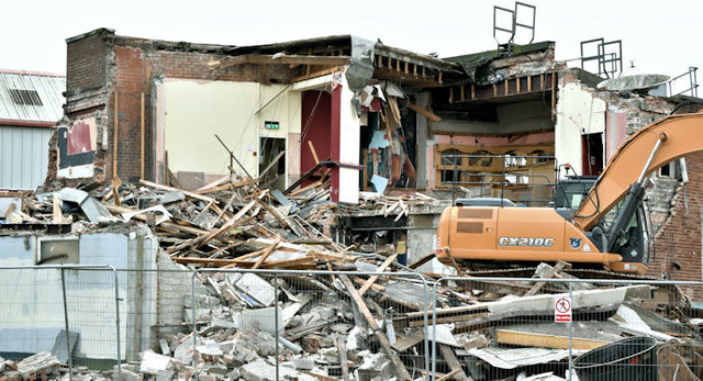
The "Stormont Inn" (demolition), Belfast - February 2017(5)
The remains of the rear extension.
Nos 165/169 Holywood Road, Belfast (proposed redevelopment)
Currently occupied by the Stormont Inn there is the following application for planning permission LA04/2015/1160/F Thu 24 Sep 2015 165-169 Holywood Road Belfast BT4 3BE Demolition of existing building and construction of 18 apartments. The photographs submitted by me appear as a matter of neutral historical record only. I have no connection with any of the parties involved in the development and have no opinion about the application. I cannot enter into correspondence.
Loading map... (JavaScript required)
- Grid Square
- J3774, 464 images (more nearby 🔍)
- Photographer
- Albert Bridge (more nearby)
- Date Taken
- Saturday, 25 February, 2017 (more nearby)
- Submitted
- Saturday, 25 February, 2017
- Subject Location
-
Irish:
 J 371 745 [100m precision]
WGS84: 54:36.0286N 5:52.7305W - Camera Location
-
Irish: J 370 745
- View Direction
- EAST (about 90 degrees)