1991
SJ6475 : The Anderton Lift Lock
taken 33 years ago, near to Anderton, Cheshire West And Chester, England
This is 1 of 3 images, with title starting with The Anderton Lift in this square
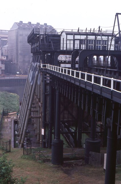
The Anderton Lift Lock
Ranking alongside the Pontcysyllte Aqueduct as one of the great icons of the British canal network, the boat lift at Anderton was an ingenious Victorian solution to the problem of transferring boats the 50 feet between the Trent and Mersey Canal and the River Weaver. It was originally built in 1875 with two caisson, one of which is lowered as the other is raised. In the original design, steam operated hydraulic rams were assisted by pumping some water out of the ascending caisson, thus making it lighter. Unfortunately the equipment proved unreliable mainly due to corrosion caused by using polluted canal water for the hydraulics, and the lift was extensively modified in 1908 using an electric system. The lift had to be closed again in 1983 when corrosion was found in the superstructure and it seemed unlikely that it would ever operate again; contemporary photographs show the lift in a very dilapidated condition. However, towards the end of the 1990s, with a contribution from the Heritage Lottery Fund, money was raised to restore the lift using a version of the original hydraulic system - this time using oil rather than canal water. The fully restored lift was opened in 2002 and is now a major tourist attraction as well as an important component of the canal network.
See other images of Anderton Boat Lift
See other images of Anderton Boat Lift
 Map © Crown Copyright")
TIP: Click the map for more Large scale mapping
- Grid Square
- SJ6475, 410 images (more nearby 🔍)
- Photographer
- David Smith (more nearby)
- Date Taken
- Saturday, 6 July, 1991 (more nearby)
- Submitted
- Tuesday, 28 March, 2017
- Subject Location
-
OSGB36:
 SJ 647 752 [100m precision]
WGS84: 53:16.3778N 2:31.8294W - Camera Location
-
OSGB36: SJ 647 752
- View Direction
- Southwest (about 225 degrees)