2017
NH5246 : Beauly Market Cross
taken 7 years ago, near to Beauly, Highland, Scotland
This is 1 of 13 images, with title starting with Beauly in this square
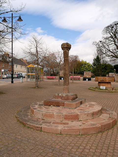
Beauly Market Cross
Although being re-sited a number of times, and having lost some of its original fabric, the market cross at Beauly is one of the oldest surviving standing market crosses in Scotland.
It is believed that the cross was originally erected on the high road above Beauly by Lord Hugh Fraser in ca1430 and that in 1746 the cross was broken into several pieces with the pedestal being removed to Belladrum. The cross was re-erected sometime after this using an internal iron rod and relocated to the market square to a position nearby Beauly Priory and has since been moved to a number of locations within the northern end of the square. Due to the deteriorating condition of the cross, the shaft was detached from the base and stored in pieces in the priory during the 1970s. The cross was re-erected again in the late 1980s and once more re-positioned in the square using part of the original plinths and a new stone base. Various remedial works have been carried since its re-erection in the late 1980s.
Beauly Market Cross is designated as a Category B listed building (Historic Scotland LB49635 Link ) being a significant remaining part of earlier 14th century market cross.
It is believed that the cross was originally erected on the high road above Beauly by Lord Hugh Fraser in ca1430 and that in 1746 the cross was broken into several pieces with the pedestal being removed to Belladrum. The cross was re-erected sometime after this using an internal iron rod and relocated to the market square to a position nearby Beauly Priory and has since been moved to a number of locations within the northern end of the square. Due to the deteriorating condition of the cross, the shaft was detached from the base and stored in pieces in the priory during the 1970s. The cross was re-erected again in the late 1980s and once more re-positioned in the square using part of the original plinths and a new stone base. Various remedial works have been carried since its re-erection in the late 1980s.
Beauly Market Cross is designated as a Category B listed building (Historic Scotland LB49635 Link
 Map © Crown Copyright")
TIP: Click the map for more Large scale mapping
- Grid Square
- NH5246, 139 images (more nearby 🔍)
- Photographer
- David Dixon (more nearby)
- Date Taken
- Thursday, 6 April, 2017 (more nearby)
- Submitted
- Wednesday, 12 April, 2017
- Subject Location
-
OSGB36:
 NH 526 464 [100m precision]
WGS84: 57:29.0344N 4:27.5590W - Camera Location
-
OSGB36: NH 526 464
- View Direction
- Southwest (about 225 degrees)