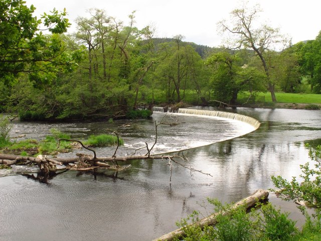
SJ1943 : The Horseshoe Falls
taken 7 years ago, near to Berwyn, Denbighshire/Sir Ddinbych, Wales
The Llangollen canal is an arm of the Shropshire Union canal that runs from Hurleston Junction to Llangollen with a wide variety of scenery along its course. Its total length is 46 miles, but the last 1½ miles from Llangollen to Llantisilio is unnavigable by any boats over about 10' length.
The canal's vital statistics for craft are:
Length 72 '
Beam 6'10"
Headroom 7'
Draught 2'3" (Hurleston to Pontcysyllte) 2' (P. to Llangollen)
These are the maximum dimensions for any craft, based on the minimum dimensions of locks & bridges.
There are a total of 21 locks on the canal, but only two between Llangollen and Whitchurch (a distance of about 31 miles). One of the most notable things about the canal is the strong flow especially in the "narrows" near Llangollen and in the tunnels near Chirk. About 12 million gallons of water passes down this canal from the River Dee to the Shropshire Union every day.
The most famous feature of this canal is the superb feat of engineering that is the 200-year-old Pontcysyllte Aqueduct rising 126' above the River Dee and running for over 335 yds - for more information on this see the numerous photos for squares SJ2742 and SJ2741
The Afon Dyfrdwy (The River Dee) is a sixty-eight mile long river which rises at Llanuwchllyn in Snowdonia. The river travels in a south-easterly direction, making its way across the border into England. It then changes course to a northerly direction towards its estuary, between North Wales and The Wirral Peninsula in England. It drains into Liverpool Bay and the Irish Sea.
The River Dee's course takes it through the Welsh towns of Berwyn, Corwen, Llangollen, Wrexham and Connah's Quay, the English town of Farndon and the English city of Chester. At Wrexham the river is a natural border between Wales and England. At Connahs Quay the river becomes tidal for the last sixteen miles.
 Map © Crown Copyright")
- Grid Square
- SJ1943, 326 images (more nearby 🔍)
- Photographer
- Stephen Craven (more nearby)
- Date Taken
- Sunday, 21 May, 2017 (more nearby)
- Submitted
- Sunday, 11 June, 2017
- Subject Location
-
OSGB36:
 SJ 195 433 [100m precision]
WGS84: 52:58.8750N 3:11.9903W - Camera Location
-
OSGB36: SJ 195 433
- View Direction
- West-northwest (about 292 degrees)