SE7423 : Stanhope Dock, Goole
taken 7 years ago, near to Goole, East Riding of Yorkshire, England
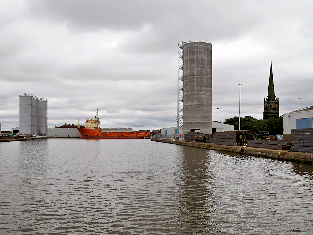
The tower and spire of St John's Church are instantly recognisable on the right hand side.
The Port of Goole developed once the canal had been constructed to transport coal from Knottingley in the northern sector of the coalfield in 1826. When the canal was completed, the Aire and Calder Navigation Company developed a new floating dock, capable of handling larger sea-going vessels. The town of Goole was built around the docks to house both the dock workers and visiting seamen. The town has grown from a community of about 450 people when Goole opened as a port on 20 July 1826, to its present size with a population of about 18,000 inhabitants
Three locks keep the water in 37 acres of floating docks at a constant depth of 6 metres (20 ft), by preventing the level from rising and falling with the tides in the River Ouse. Once ships are within the complex, eight docks provide a total quayside of 3 miles. Beside the docks are transit sheds where cargo is stored, many of which are equipped with overhead cranes.
For most of its life, the port was most associated with the shipment of coal, and associated cargoes including the importation of pit props. Goole's success as a port came from its ability to compete with the railways to export coal from the Humber. A major factor was the introduction, in 1863, of The Tom Pudding system of compartment boats Link, which could carry around 40 long tons (41,000 kg) of coal. On reaching the docks, the barges were lifted by large hoists, from which they could be discharged directly into seagoing ships, a system which proved so successful that it competed against rail until 1985 (Link
Following the decline of the coal industry, Goole has developed to handle a range of cargoes such as dry bulks including animal feed, agribulks, biomass, cement, cereals, clay products, construction materials, scrap metal, solid fuel. Timber is predominantly imported from Russia and the Baltic States, Finland, and Sweden. Storage facilities are in operation at Barge Dock for the storage of imported Liquid bulks such as vegetable oils (Link
 Map © Crown Copyright")
- Grid Square
- SE7423, 306 images (more nearby 🔍)
- Photographer
- David Dixon (more nearby)
- Date Taken
- Wednesday, 5 July, 2017 (more nearby)
- Submitted
- Wednesday, 12 July, 2017
- Subject Location
-
OSGB36:
 SE 744 234 [100m precision]
WGS84: 53:42.1203N 0:52.4247W - Camera Location
-
OSGB36: SE 744 233
- View Direction
- NORTH (about 0 degrees)