SX5057 : Fort Austin
taken 7 years ago, near to Crownhill, Plymouth, England
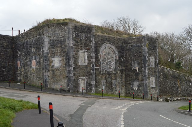
Fort Austin is one of several Palmerston Forts built around northern plymouth, in the 1860s to defend the city. The fort is rather dilipidated and due for regenertion.
Eggbuckland is a suburb of Plymouth. Prior to the Second World War Eggbuckland was a small village. During the reconstruction of Plymouth many new suburbs were built and soon a new estate was built within one mile to the south east of Eggbuckland. During the 1970s the areas in between and surrounding the old village were all developed and the whole area is now referred to by the name Eggbuckland. The development of the A38 just south of Eggbuckland in the 1980s lead to the area becoming very popular with commuters.
During the 19th century the area was host to new Palmerston Forts built as part of a northern defence line around Plymouth.
Over time the name has been corrupted and by 1685 was Egg Buckland. By 1902, it was one word - Eggbuckland.
 Map © Crown Copyright")
- Grid Square
- SX5057, 37 images (more nearby 🔍)
- Photographer
- N Chadwick (more nearby)
- Date Taken
- Sunday, 12 February, 2017 (more nearby)
- Submitted
- Monday, 17 July, 2017
- Subject Location
-
OSGB36:
 SX 5057 5761 [10m precision]
WGS84: 50:23.9593N 4:6.2343W - Camera Location
-
OSGB36: SX 5053 5762
- View Direction
- EAST (about 90 degrees)