2017
SU3227 : River Test, Mottisfont Abbey
taken 7 years ago, near to Mottisfont, Hampshire, England
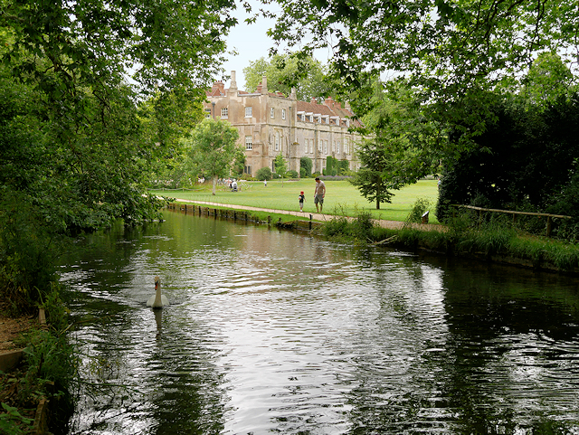
River Test, Mottisfont Abbey
An Augustinian priory was founded here in 1201. The canons welcomed pilgrims en route to Winchester, who came to worship Mottisfont's relic, said to be the finger of St John the Baptist. During the Henry VIIIs Dissolution of the Monasteries, the priory was dissolved and given by the King to Sir William Sandys who turned it into a country home. Rather than completely demolishing the priory, Sandys chose to convert the church nave into the main body of his new mansion. Sections of the original mediæval church may still be seen, with the later additions built around them. The Thirteenth century cellarium also remains present today.
In the 18th century, the old monastic cloisters and Tudor courtyard were demolished creating the modern appearance of the estate's facade. It was at this time that the owners changed the name of the house to "Mottisfont Abbey". It has been speculated that the word "Abbey" was added to the name "Mottisfont " as that the name was considered more romantic than the historically-correct "Priory" (Archive Link national Trust archived link).
The house and grounds were gifted to the National Trust in 1957 and are open to the public. The house is a Grade I listed building (List entry Number: 1093730 Link Historic England).
In the 18th century, the old monastic cloisters and Tudor courtyard were demolished creating the modern appearance of the estate's facade. It was at this time that the owners changed the name of the house to "Mottisfont Abbey". It has been speculated that the word "Abbey" was added to the name "Mottisfont " as that the name was considered more romantic than the historically-correct "Priory" (Archive Link
The house and grounds were gifted to the National Trust in 1957 and are open to the public. The house is a Grade I listed building (List entry Number: 1093730 Link
River Test
The River Test rises near the village of Ashe, 10 km to the west of Basingstoke and flows through Hampshire for 40 miles through downland to its estuary at Southampton, where it converges with the River Itchen to form Southampton Water. In its upper reaches it is a chalk stream, and is used for fly fishing for trout.
 Map © Crown Copyright")
TIP: Click the map for more Large scale mapping
- Grid Square
- SU3227, 225 images (more nearby 🔍)
- Photographer
- David Dixon (more nearby)
- Date Taken
- Sunday, 16 July, 2017 (more nearby)
- Submitted
- Wednesday, 19 July, 2017
- Subject Location
-
OSGB36:
 SU 328 270 [100m precision]
WGS84: 51:2.5015N 1:31.9776W - Camera Location
-
OSGB36: SU 328 270
- View Direction
- West-southwest (about 247 degrees)