2017
SJ7994 : Base of former Stretford Cross
taken 7 years ago, near to Stretford, Trafford, England
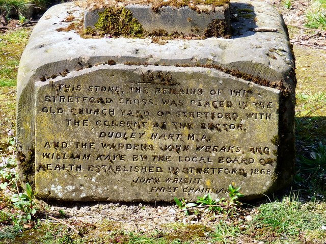
Base of former Stretford Cross
This cross base, later used as a sundial base is said to be of Medieval origin. The roughly hewn stone is cubic shape with remains of sundial shaft at top and one side refaced and inscribed in 1863 to commemorate its removal from the junction of Chester Road and King Street to the old churchyard SJ7994 : St Matthew's churchyard.
The text reads:
THIS STONE, THE REMAINS OF THE
STRETFORD CROSS, WAS PLACED IN THE
OLD CHURCH YARD OF STRETFORD WITH
THE CONSENT OF THE RECTOR,
DUDLEY HART M.A.
AND THE WARDENS JOHN WREAKS AND
WILLIAM KAYE BY THE LOCAL BOARD OF
HEALTH ESTABLISHED IN STRETFORD 1868
JOHN WRIGHT
FNRST CHAIRMAN
It is Grade II listed Link
 Map © Crown Copyright")
TIP: Click the map for more Large scale mapping
- Grid Square
- SJ7994, 137 images (more nearby 🔍)
- Photographer
- Gerald England (more nearby)
- Date Taken
- Saturday, 8 April, 2017 (more nearby)
- Submitted
- Wednesday, 20 September, 2017
- Subject Location
-
OSGB36:
 SJ 7944 9418 [10m precision]
WGS84: 53:26.6390N 2:18.6602W - Camera Location
-
OSGB36: SJ 7945 9417
- View Direction
- Northwest (about 315 degrees)