2017
J2105 : View West along the cliff line between Cooley Point and the Templetown road
taken 6 years ago, 6 km S of Greenore, Co Louth, Ireland
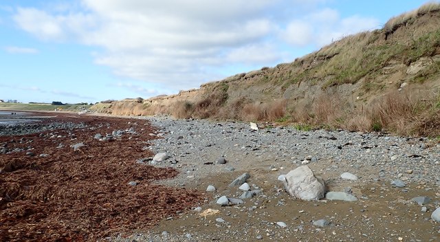
View West along the cliff line between Cooley Point and the Templetown road
The 6m high cliffs running some 400m between Templetown and Cooley Point are the product of glaciomarine sedimentation some 15,000BP. The cliffs exhibit four distinct layers.
1] basal mud facies, some 1.5m thick, deposited from sediment plumes after the initial retreat of the ice. These marine deposited muds are fossiliferous and contain the remains of minute Arctic fauna including Elphidium clavatum and Roundstoniaglobulifera.
2]Above the mud is a tightly packed boulder pavement only one clast thick formed of local Carboniferous rocks which has been pressed into the mud below. It is the product of intertidal activity at a period of ice readvance. The boulders would have been transferred to the area on ice flows which melted depositing their load on the sea bed.
3] A layer of laminated sand and mud deposited by glacial meltwater. These are ground up sandstone and this would suggest that their source origin was the Dundalk Bay ice lobe. Cross bedding is common in this layer.
4] An overlying gravel layer laid down by glacial melt water.
Following the Ice Age. the coastal areas of the Cooley Peninsula were subject to isostatic uplift leading to the formation of raised beaches which are in the process of being eroded by the sea.
See other images of Cooley Point
Loading map... (JavaScript required)
- Grid Square
- J2105, 58 images (more nearby 🔍)
- Photographer
- Eric Jones (more nearby)
- Date Taken
- Friday, 27 October, 2017 (more nearby)
- Submitted
- Wednesday, 15 November, 2017
- Subject Location
-
Irish:
 J 217 051 [100m precision]
WGS84: 53:58.8875N 6:8.6667W - Camera Location
-
Irish: J 219 051
- View Direction
- WEST (about 270 degrees)