2007
SP3379 : Priory Row, Priory Place and Swanswell
taken 17 years ago, near to Coventry, England
This is 1 of 5 images, with title starting with Priory Row in this square
Priory Row, Priory Place and Swanswell
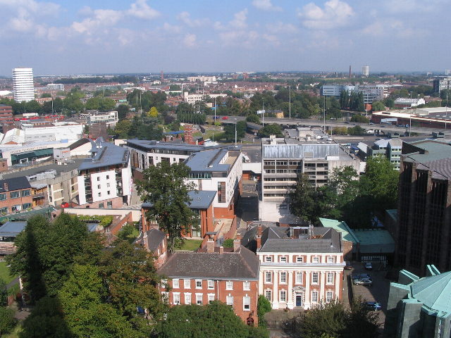
From the tower of St Michael's cathedral church. Foreground: Part of the Cathedral. Georgian houses in Priory Row (nos. 9-11). No. 11, the Dean's House has white, fluted Ionic pilasters on its frontage. These houses are positioned on the crossing and chancel of the 12th century St Mary's Cathedral, lost after the Dissolution. To the left, behind the trees, is the Priory Visitor Centre, within which can be seen the remains of the Priory undercroft and some of the items excavated from the site. The white buildings are in Priory Place. To their left the white roof of the Coventry Transport Museum can be seen.
The trees within the ring road are in Lady Herberts Garden. Beyond the road is Swanswell pool and park, next to which are the grey buildings of the new City College. The tower block to the left, middle distance is William Batchelor residential block by the canal basin.
The white block just visible on the centre horizon is the Ricoh Arena on the old Foleshill gas works site.
A 1975 view in this direction: Link
Views from St Michael's tower
High-level views of Coventry from the tower of St Michael's cathedral church ('the old cathedral').
 Map © Crown Copyright")
TIP: Click the map for more Large scale mapping
- Grid Square
- SP3379, 1833 images (more nearby 🔍)
- Photographer
- E Gammie (more nearby)
- Date Taken
- Thursday, 13 September, 2007 (more nearby)
- Submitted
- Wednesday, 19 September, 2007
- Subject Location
-
OSGB36:
 SP 335 791 [100m precision]
WGS84: 52:24.5544N 1:30.4668W - Camera Location
-
OSGB36: SP 335 790
- View Direction
- NORTH (about 0 degrees)