2018
NC2423 : Eadar a' Chalda Ruin
taken 6 years ago, near to Inchnadamph, Highland, Scotland
Eadar a' Chalda Ruin
Eadar a' Chalda Ruin
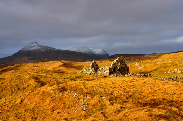
The building was erected as an inn; exactly what date it was built is now lost in time, but it would have been in full use when the marble was being quarried over at Leadbeg by Jobson. The marble was dragged by sledge pulled by oxen across the hill to a pier at Newton near Kylesku. Then it was shifted by boat to wherever it was needed. Some of it is supposedly part of the Marble Arch in London . Eadar a' Chalda ruin was all built from hammer-cut stone and was well constructed I am sure that it would have seen a good tradel there was even a murder committed in it according to my research, not uncommon for an inn in those days. The inn would have fallen victim to the Highland clearances and left to revert slowly back to nature; the gable ends are in a perilous state and a few more winters could well bring them down.
The building was erected as an inn; exactly what date it was built is now lost in time, but it would have been in full use when the marble was being quarried over at Leadbeg by Jobson. The marble was dragged by sledge pulled by oxen across the hill to a pier at Newton near Kylesku. Then it was shifted by boat to wherever it was needed. Some of it is supposedly part of the Marble Arch in London . Eadar a' Chalda ruin was all built from hammer-cut stone and was well constructed I am sure that it would have seen a good tradel there was even a murder committed in it according to my research, not uncommon for an inn in those days. The inn would have fallen victim to the Highland clearances and left to revert slowly back to nature; the gable ends are in a perilous state and a few more winters could well bring them down.
 Map © Crown Copyright")
TIP: Click the map for more Large scale mapping
- Grid Square
- NC2423, 101 images (more nearby 🔍)
- Photographer
- Donald H Bain (more nearby)
- Date Taken
- Friday, 2 February, 2018 (more nearby)
- Submitted
- Friday, 2 February, 2018
- Subject Location
-
OSGB36:
 NC 24323 23810 [1m precision]
WGS84: 58:10.0857N 4:59.2970W - Camera Location
-
OSGB36: NC 2432 2379
- View Direction
- North-northwest (about 337 degrees)