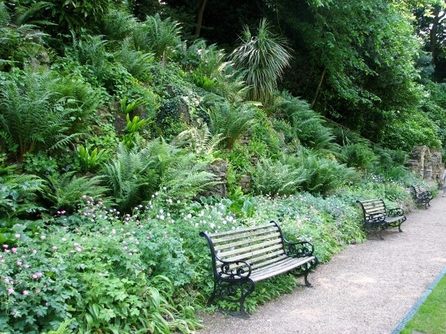
TG2208 : The Plantation Garden - seats beside the path
taken 6 years ago, near to Eaton, Norfolk, England
The Plantation Garden > Link is a Grade 2 listed Victorian garden created by the well-to-do upholsterer and cabinet maker Henry Trevor, who in 1856 took over the lease of the site, a disused chalk quarry, and built his dwelling there, which he called Plantation House. Between 1856 and 1891/92, he also created the immediately adjacent Plantation Garden, an area encompassing almost 3 acres of ground and featuring a rustic bridge > Link at one end and Italianate terraces with balustrades > Link at the other, and many other things to discover on the way.
At the bottom of the former quarry there are a Gothic fountain (built in 1857) > Link and lawns and flowerbeds, a number of follies > including a Gothic alcove > Link and a church window > Link and seats beside the paths > Link for taking a rest or having a picnic.
Several retaining walls > Link - Link and also the walls of the Italianate terrace incorporate a range of ornamental bricks, most having been produced by the Gunton Brothers' brickworks in Costessey and known as Cosseyware > Link - Link. Fragments of more than 15 of their 34 patterns on chimneys, for instance, can be seen here. The fountain as well as the follies also contain pieces of ornamental Cosseyware.
Higher up, serpentine paths > Link - Link take the visitor along circular routes around the garden at different levels, offering many pleasant views > Link. The Plantation Garden, described as one of the finest surviving Victorian gardens in England, is open every day > Link. It is managed by the Plantation Garden Preservation Trust (PGPT), a registered charity formed in 1980.
 Map © Crown Copyright")
- Grid Square
- TG2208, 4039 images (more nearby 🔍)
- Photographer
- Evelyn Simak (more nearby)
- Date Taken
- Wednesday, 13 June, 2018 (more nearby)
- Submitted
- Thursday, 14 June, 2018
- Subject Location
-
OSGB36:
 TG 2220 0850 [10m precision]
WGS84: 52:37.7248N 1:16.9088E - Camera Location
-
OSGB36: TG 2220 0850
- View Direction
- South-southwest (about 202 degrees)