TQ6242 : Old Church of St Peter
taken 6 years ago, near to Crockhurst Street, Kent, England
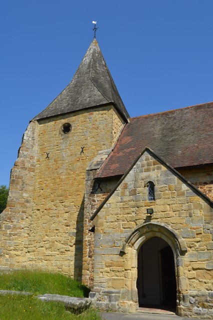
Pembury has two churches dedicated to St Peter. The oldest, known as the Old Church, stands outside the modern village in the woods to the north of the A228 bypass. The newer building, known as the Upper Church ( Link ), stands in the heart of the village on Hastings Road.
The plan of the Old Church and the little Norman window above the South door indicate that the original Church dates from 1147 at least, or even 1100AD. Most of the present Church was built in 1337 by John Colepeper of Bayhall. He also built the chantry chapel of St Mary in the churchyard in 1355 but this was pulled down at the Dissolution of the smaller Monasteries in 1547 and three windows in the body of the Church were inserted with the money gained from the sale of the lead which had covered the chapel.
The most notable feature inside the Church is the roof of the nave. It is said to be one of the best specimens of the tie-beam and kingpost type in the country.
It is Grade I listed. Link
Grade I listed buildings and structures are of exceptional, even international importance. There are over 6,000 in the country. Only 2.5% of listed buildings are Grade I listed.
In Scotland the classification is Category A
Index: Link
 Map © Crown Copyright")
- Grid Square
- TQ6242, 243 images (more nearby 🔍)
- Photographer
- N Chadwick (more nearby)
- Date Taken
- Saturday, 19 May, 2018 (more nearby)
- Submitted
- Monday, 24 September, 2018
- Subject Location
-
OSGB36:
 TQ 6259 4297 [10m precision]
WGS84: 51:9.7726N 0:19.4363E - Camera Location
-
OSGB36: TQ 6260 4296
- View Direction
- North-northwest (about 337 degrees)