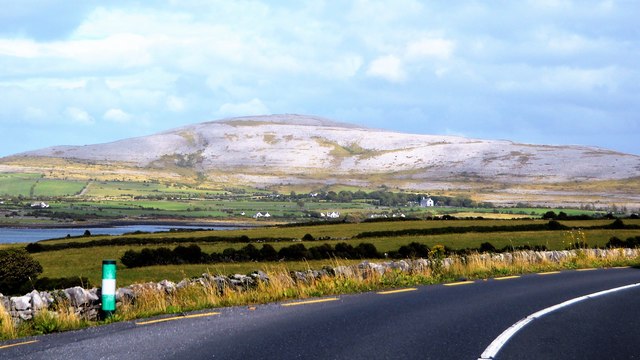
M2610 : N67 and limestone scenery
taken 6 years ago, near to Finvarra, Co Clare, Ireland
The Burren and Cliffs of Moher Geopark is an internationally designated area of geological interest in County Clare. It was the third Geopark to be designated in Ireland, and is recognised at both European and global levels. It is sometimes branded as "the Burren and Cliffs of Moher Global UNESCO Geopark."
The Burren comprises dramatic glaciated karst landscapes on Irelands Atlantic coast which have been fashioned in a variety of limestones, sandstones and siltstones originating during the Carboniferous period. The nearby Cliffs of Moher are vertical sandstone and shale sea-cliffs, the highest in Europe, which rise to a height of over 200m in places and which have long drawn sightseers to the area.
The Wild Atlantic Way is a tourist trail on the west coast, and on parts of the north and south coasts, of Ireland. The 2,500 km (1,553 mile) driving route passes through nine counties and three provinces, stretching from County Donegal's Inishowen Peninsula in Ulster to Kinsale, County Cork, in Munster, on the Celtic Sea coast.
The route is broken down into 5 sections.
County Donegal
County Donegal to County Mayo
County Mayo to County Clare
County Clare to County Kerry
County Kerry to County Cork
Along the route there are 157 discovery points, 1,000 attractions and more than 2,500 activities. The route was officially launched in 2014.
Website: Link
- Grid Square
- M2610, 20 images (more nearby 🔍)
- Photographer
- N Chadwick (more nearby)
- Date Taken
- Tuesday, 31 July, 2018 (more nearby)
- Submitted
- Wednesday, 14 November, 2018
- Subject Location
-
Irish:
 M 263 101 [100m precision]
WGS84: 53:8.2029N 9:6.0362W - Camera Location
-
Irish: M 263 101
- View Direction
- East-southeast (about 112 degrees)