Geograph - photograph every grid square
2007
ST7069
: 2007 : Pipley Bottom
taken
16 years ago
,
near
to
North Stoke
, Bath And North East Somerset, England
This is 1 of
2 images, with title 2007 : Pipley Bottom
in this square
2007 : Pipley Bottom
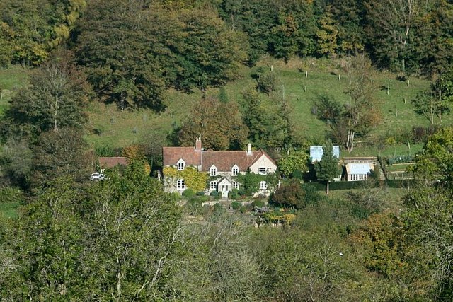
Looking north across Pipley Bottom from the ancient hill fort at Little Down.
Hanging Hill rises beyond the house.
© Copyright
Maurice Pullin
and licensed for
reuse
under this
Creative Commons Licence
.
Licensing
Download
Share...
Share this photo via Twitter
Share this photo via Facebook
Share this photo via Pinterest
Share this photo via Flipboard
Share this photo via email/e-card
Grab a Stamped/Watermarked Image
Mark
👍🏻
Like Image
👍🏻
Like Description
Update Information
Contact Contributor
Category:
House
This photo is linked from:
Automatic Clusters
: ·
Pipley [6]
·
Hill Fort [5]
·
Little Down Hill Fort [3]
Title Clusters
: ·
2007 : Pipley Bottom [2]
·
TIP: Click the map for more Large scale mapping
Grid Square
ST7069
, 50 images (
more nearby
🔍
)
Photographer
Maurice Pullin
(
more nearby
)
Date Taken
Monday, 29 October, 2007 (
more nearby
)
Submitted
Tuesday, 30 October, 2007
Subject Location
OSGB36:
ST 709 697
[100m precision]
WGS84:
51:25.5711N
2:25.1615W
Camera Location
OSGB36:
ST 709 690
View Direction
NORTH (about 0 degrees)
NW
N
NE
W
Go
E
SW
S
SE
Discuss ST7069
View this location on ...
Geograph Coverage Map (includes OSM etc)
Geograph Links Page
Open in Google Maps
Navigate to location with Google Maps
Open in Google Earth Pro
Open in Google Earth for Web
Open in Bing Maps
Navigate with Google Maps
Lookup nearest Postcode
Image classification
(about)
: Geograph (Third Visitor for ST7069)
This page has been
viewed
about
95
times
☰
Home
View
Search
Marked Images
Maps
Browser
Explore
Showcase
New Images
Collections
Interact
Games
Discussions
Blog
Contributors
Submit
Statistics
Leaderboards
General
FAQ
Help Pages
Sitemap
Contact Us
Support Us
sponsored by
🔍
What to search:
Photos
Enter keywords or a location/postcode to search nearby images
Photos near ST7069
Enter a Grid Reference
Placenames
Collections
Website Pages
Everything
Others:
Advanced Search
|
Image Browser
Or:
Coverage Map
|
Searchable Map
You are not logged in
login
|
register