1969
SJ8394 : Cenacle Convent, Alexandra Road, Whalley Range
taken 54 years ago, near to Withington, Manchester, England
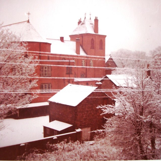
Cenacle Convent, Alexandra Road, Whalley Range
The Cenacle convent building was based on a French design with a large bell tower. The convent was originally designed to be more or less self sufficient, with large grounds containing fruit trees, greenhouses, poultry sheds, etc. Economic considerations led to the building being demolished in the 1970s, leaving the order running a retreat house on the site. Some of the other buildings were used by the St Bede's College nearby and later large parts of the grounds were sold. A housing development was built on this in about 2006.
This photo was taken from the house at 7 Wellington Road, which has now been demolished. Also see SJ8394 : Wellington Road, Whalley Range, Autumn SJ8394 : Wellington Road, Whalley Range
Had this convent survived into the 1990s, I feel sure that it would have been converted into architect designed apartments. The ones in the bell tower would have had immense views. A church not far away from here - St Edmunds - opposite to Alexandra Park, now houses many unique apartments. And St Edmunds was not in the same architectural league as the Cenacle Convent.
Also see SJ8394 : St Regis Building, Wellington Road, Whalley Range and SJ8394 : Lodge building, St Bede's College, Alexandra Road, Whalley Range
 Map © Crown Copyright")
TIP: Click the map for more Large scale mapping
- Grid Square
- SJ8394, 75 images (more nearby 🔍)
- Photographer
- Tom Jolliffe (more nearby)
- Date Taken
- December 1969 (more nearby)
- Submitted
- Friday, 7 December, 2007
- Subject Location
-
OSGB36:
 SJ 833 948 [100m precision]
WGS84: 53:27.0140N 2:15.1756W - Camera Location
-
OSGB36: SJ 832 949
- View Direction
- Southeast (about 135 degrees)