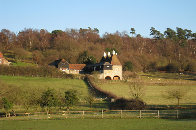
TQ4652 : Oast House at Outridge Farm, Brasted, Kent
taken 16 years ago, near to Brasted Chart, Kent, England
See other images of Listed Oast Houses
See other images of Unconverted, Disused & Working Oast Houses
Owned by the National Trust, this unique stone built oast house has arched undercrofts beneath the nearest end of the building and three octagonal cowls.
Grade II listed.
An Oast House is a building used to dry fresh hops before they are sent to the brewers, to be used for flavouring beer. A traditional Oast House consists of the 'oast' and the 'stowage'. The oast was a kiln, with a plenum chamber fired by charcoal at ground floor and the drying floor directly above. The steep pitched roof channelled the hot air through the hops to the top. The stowage, was the barn section, it had a cooling floor and press at first floor and storage area at ground floor. Read more Link
A National Trust is an organization dedicated to preserving the cultural or environmental treasures of a particular geographic region. They generally operate as private non-profit organizations, although some receive considerable support from their national government. The first such organization was the National Trust for Places of Historic Interest or Natural Beauty, which is the National Trust of England, Wales and Northern Ireland, formed in 1895 and operating as a charitable organisation.
Extract from Wikipedia Link
List of National Trust places Link
 Map © Crown Copyright")
- Grid Square
- TQ4652, 66 images (more nearby 🔍)
- Photographer
- Oast House Archive (more nearby)
- Date Taken
- Wednesday, 12 December, 2007 (more nearby)
- Submitted
- Wednesday, 12 December, 2007
- Subject Location
-
OSGB36:
 TQ 4639 5262 [10m precision]
WGS84: 51:15.2377N 0:5.7816E - Camera Location
-
OSGB36: TQ 4607 5249
- View Direction
- East-northeast (about 67 degrees)