1976
TL0426 : Sundon South Chalk Pit
taken 48 years ago, near to Lower Sundon, Central Bedfordshire, England
This is 1 of 4 images, with title Sundon South Chalk Pit in this square
Sundon South Chalk Pit
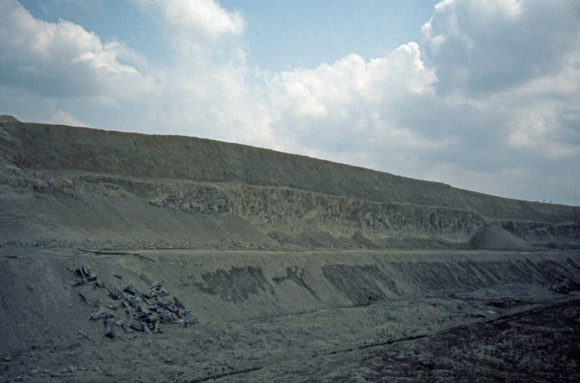
This cement plant quarry ceased operation in December 1976. The photograph was taken earlier that year. The pit is about the same now, although full of trash and less easily interpreted due to weathering. The blocky material in the middle of the upper quarry face is Totternhoe Stone, the lowest member of the "Grey Chalk". Below it is the "Chalk Marl". The calcium carbonate content of the rock varied steadily from 60% at the bottom to 85% at the top. A cement rawmix of 78.5% carbonate was made by combining the layers.
The chalk was dug with three excavators. A dragline on the hill top scraped the soft chalk from above the Totternhoe Stone and dropped it onto the lower bench, forming the scree-like piles visible here. A face shovel on the lower bench undermined and prised out the hard Totternhoe Stone, and loaded it and the soft chalk into rail trucks (see TL0426 : Sundon South Chalk Pit). A second dragline, also on the lower bench, scraped marl up from below, and added it to the rail trucks. The chemistry of the mixture was controlled by specifying the number of buckets of marl to be added to each train-load.
The chalk was dug with three excavators. A dragline on the hill top scraped the soft chalk from above the Totternhoe Stone and dropped it onto the lower bench, forming the scree-like piles visible here. A face shovel on the lower bench undermined and prised out the hard Totternhoe Stone, and loaded it and the soft chalk into rail trucks (see TL0426 : Sundon South Chalk Pit). A second dragline, also on the lower bench, scraped marl up from below, and added it to the rail trucks. The chemistry of the mixture was controlled by specifying the number of buckets of marl to be added to each train-load.
 Map © Crown Copyright")
TIP: Click the map for more Large scale mapping
- Grid Square
- TL0426, 17 images (more nearby 🔍)
- Photographer
- Dylan Moore (more nearby)
- Date Taken
- Sunday, 2 May, 1976 (more nearby)
- Submitted
- Tuesday, 1 January, 2008
- Subject Location
-
OSGB36:
 TL 041 268 [100m precision]
WGS84: 51:55.8037N 0:29.1651W - Camera Location
-
OSGB36: TL 040 268
- View Direction
- EAST (about 90 degrees)