2008
SH3644 : Mynydd Gwaith, Yr Eifl and Tre'r Ceiri from Mynydd Carnguwch
taken 16 years ago, near to Llanaelhaearn, Gwynedd, Wales
This is 1 of 2 images, with title starting with Mynydd in this square
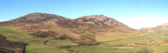
Mynydd Gwaith, Yr Eifl and Tre'r Ceiri from Mynydd Carnguwch
The summit of Mynydd Gwaith can just be seen peeping over the shoulder of Yr Eifl on the very left of the photo. The three peaks are also collectively known as Yr Eifl.
 Map © Crown Copyright")
TIP: Click the map for more Large scale mapping
- Grid Square
- SH3644, 55 images (more nearby 🔍)
- Photographer
- Eric Jones (more nearby)
- Date Taken
- Sunday, 3 February, 2008 (more nearby)
- Submitted
- Sunday, 9 March, 2008
- Subject Location
-
OSGB36:
 SH 368 445 [100m precision]
WGS84: 52:58.3780N 4:25.8409W - Camera Location
-
OSGB36: SH 375 429
- View Direction
- North-northwest (about 337 degrees)