2008
SU3268 : Marsh Lock, number 73
taken 16 years ago, near to Hungerford, West Berkshire, England
This is 1 of 2 images, with title Marsh Lock, number 73 in this square
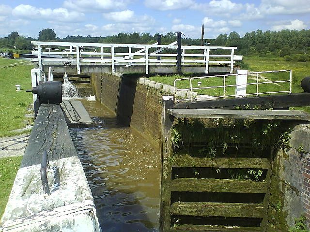
Marsh Lock, number 73
This is an unusual but logical arrangement where the swingbridge goes over the lock, thus saving the boatmen from stopping twice. Just remember to open the swingbridge before you fill the lock. It is necessary because a number of footpaths converge here, from various parts of the surrounding common land, Freeman's Marsh.
The 1:50K map struggles to show the location clearly, presumably because they need to keep the lock and bridge symbols separate. The 1:25K is better.
The 1:50K map struggles to show the location clearly, presumably because they need to keep the lock and bridge symbols separate. The 1:25K is better.
 Map © Crown Copyright")
TIP: Click the map for more Large scale mapping
- Grid Square
- SU3268, 100 images (more nearby 🔍)
- Photographer
- Graham Horn (more nearby)
- Date Taken
- Saturday, 7 June, 2008 (more nearby)
- Submitted
- Thursday, 12 June, 2008
- Subject Location
-
OSGB36:
 SU 326 685 [100m precision]
WGS84: 51:24.8912N 1:31.9054W - Camera Location
-
OSGB36: SU 327 685
- View Direction
- West-northwest (about 292 degrees)