Showing most recent first, in descending order
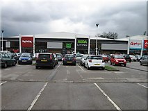
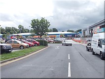
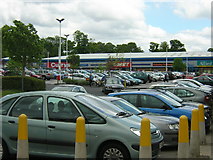
3 images in cluster West Side Retail Park in SE1941
Image clustering - assigning images labels - is an automated process, based on the image title/description. It's not totally accurate, and can sometimes assign images to odd clusters
Explore these images in the Browser or Explore matching images including in surrounding squares (if any!)
Other Automatic clusters in SE1941
- Otley Road
- Leeds Road
- Retail Park
- West
- Green
- Ghyll Royd
- Footpath
- Coach Road
- Morrisons
- Guiseley Theatre
- Railway Bridge
- Shakespeare Road
- Nunroyd Park
- Car Park
- Silverdale Drive
- Bransdale Avenue
- Town Hall but now a Theatre
- Milestone by Otley Road A65
- Near
- Wood
- Nunroyd Avenue
- Court
- Dibb Lane
- St Peter St Paul Church
- Benchmark Cut into the North-west Facing Wall
- Regent
- Primary School
- Tennyson Street
- Alternative View
- Eliot Grove
- Studio
- Redwood Way
- Springfield Court
- Bridge ILK 1/13
- New Scarborough
- Anchor Housing
- View from Bridge ILK 1/14
- Bedford Place
- Belle Vue Terrace
- Ruskin Crescent
- Row of Shops
- Inside Coopers
- Milestone Society National ID
- Closed in 1964
- Cohens Chemist
- Narrow Bridleway
- Coverley Rise
- Looking North