Public Tags
Tag: 20·Zone
Showing images tagged with 20 Zone tag.
|
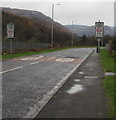
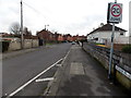
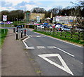
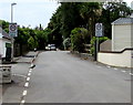
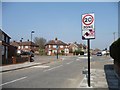
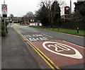
20 zone near Penyrenglyn Community Primary School
by Jaggery geograph for square SS9497 The school Link is behind the camera. PARTH... (more)
Tags:
20 Mph ZoneX
20 Zone
20mph ZoneX
type:GeographX
top:Roads, Road TransportX
top:Village, Rural SettlementX
|
|
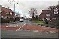
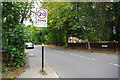
Start of the 20 zone on the approach to Eton College
by Jaggery geograph for square SU9677 The 30mph speed limit on the B3026 Eton Wick Road drops to 20.
|
|
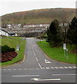
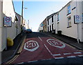
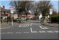
Start of the 20 zone, Wind Street, Aberdare
by Jaggery geograph for square SO0002 Viewed across the B4275 Cardiff Road. The 30mph speed limit drops to 20mph along... (more)
|
|
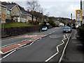
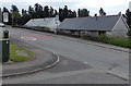
From 30 to 20 on Kensington Way, Oakengates, Telford
by Jaggery geograph for square SJ6911 The 30mph speed limit drops to 20 on the approach to the New Street junction.
|
|
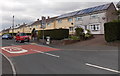
20 zone in Eastleigh Road, BS10, Bristol
by Jaggery geograph for square ST5878 A 20 mph maximum speed limit is in force near a school. Viewed from the corner... (more)
Tags:
20 Mph ZoneX
20 Zone
top:Housing, DwellingsX
top:Roads, Road TransportX
top:Suburb, Urban FringeX
|
|
Queensway 20 zone in Garnlydan
by Jaggery geograph for square SO1612 The 30mph speed limit along the B4560 Llangynidr Road reduces to
20mph in... (more)
|
|
Start of a 20 zone in Ynysmeudwy
by Jaggery geograph for square SN7204 The 30mph speed limit along the B4603 Brecon Road
reduces to 20mph on the... (more)
|
|
Water Lane, Brimscombe
by Jaggery geograph for square SO8602 Descending from Brimscombe Hill, Water Lane is unsuitable for vehicles over... (more)
|
|
Traffic calming on Causeway Road, Cinderford
by Jaggery geograph for square SO6614 Approaching the 20mph maximum speed zone near the Forest High School.... (more)
|
|
Slate roofs and a 20 zone in Garnlydan
by Jaggery geograph for square SO1612 Viewed across Prince Philip Avenue from the corner of Cynan Close.
|
|
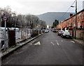
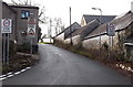
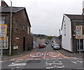
Nantcarn Road speed bump, Cwmcarn
by Jaggery geograph for square ST2293 In a 20mph maximum speed zone.
Tags:
20 Mph ZoneX
20 Zone
type:GeographX
top:Roads, Road TransportX
Speed BumpX
top:Village, Rural SettlementX
|
|
White Rose Way, Elliot's Town, New Tredegar
by Jaggery geograph for square SO1402 The speed limit drops to 20mph on the approach to White Rose Primary School.... (more)
|
|
Start of the 20 zone, Station Road, Manorbier
by Jaggery geograph for square SS0699 The National Speed Limit on Station Road drops to 20mph on the approach to the... (more)
Tags:
20 Zone
type:GeographX
top:Roads, Road TransportX
Start of 20mph ZoneX
road:Station RoadX
Station RoadX
top:Village, Rural SettlementX
|
|
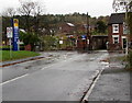
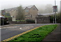
Start of the 20mph zone, Groes Road, Rogerstone, Newport
by Jaggery geograph for square ST2789 The National Speed Limit on Groes Road drops to 20mph.
Warning signs show... (more)
|
|
Junction of Rowan Way and Pillmawr Road, Malpas, Newport
by Jaggery geograph for square ST3090 At the southern end of Rowan Way, the 30mph speed limit drops to 20mph on... (more)
|
|
Up Cribbinddu Street, Ynysybwl
by Jaggery geograph for square ST0693 Cribbinddu Street ascends from Robert Street towards Thompson Street. The 30mph... (more)
|
|
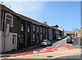
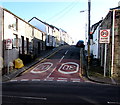
Albert Street, Aberdare
by Jaggery geograph for square SO0002 Albert Street climbs steeply away from Cross Street.
The speed limit reduces... (more)
|
|
Dumfries Street, Aberdare
by Jaggery geograph for square SO0002 Dumfries Street climbs steeply away from Cross Street.
The speed limit reduces... (more)
|
|
20 on Masefield Avenue, Warwick
by Jaggery geograph for square SP2763 The speed limit is 20mph on the approach to Newburgh Primary School.
|
|
Looking down Clarence Avenue from Kings Avenue
by Christopher Hilton geograph for square TQ3074 |
|
Manor Road
by Gerald England geograph for square SJ9394 Leading to the St John Fisher RC Primary School.
|
|
Park Road
by Gerald England geograph for square SJ9585 Off Buxton Road.
|
|
Oxford Street, Gadlys, Aberdare
by Jaggery geograph for square SN9902 Viewed across Gadlys Road. The street name sign on the left shows that Oxford... (more)
|
|
Junction of Malvern Avenue and Thistledean Avenue
by Christine Johnstone geograph for square TQ1286 Looking south-east from Torbay Road.
|
|
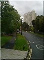
20 mph zone, Weir Hall Road
by Christine Johnstone geograph for square TQ3291 At the junction with Barclay Road.
|
|
20 zone sign on Oakfield Road, Selly Park
by Phil Champion geograph for square SP0583 Despite the signs and traffic calming measures vehicles still regularly exceed... (more)
Tags:
20 Zone
place:BirminghamX
Oakfield RoadX
Road SignX
top:Roads, Road TransportX
place:Selly ParkX
top:Suburb, Urban FringeX
Traffic CalmingX
|

|
Traffic calming on Oakfield Road
by Phil Champion geograph for square SP0583 The Selly Park area is a 20 mph speed limit zone. This is signed at the... (more)
Tags:
20 Zone
place:BirminghamX
Oakfield RoadX
top:Roads, Road TransportX
place:Selly ParkX
Speed CushionX
top:Suburb, Urban FringeX
Traffic CalmingX
|
|
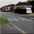
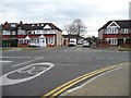
Southern end of Robert Burns Avenue, Cheltenham
by Jaggery geograph for square SO9121 Viewed across Hatherley Lane. A 20mph zone is in force near schools.
Tags:
20 Zone
type:GeographX
top:Housing, DwellingsX
Road JunctionX
top:Roads, Road TransportX
Start of 20mph ZoneX
top:Suburb, Urban FringeX
|
|
Vicarage Grove, Camberwell, London
by Robin Stott geograph for square TQ3276 Compare Paul Farmer's 2010 shot from further down the street: TQ3276 : Vicarage Grove Camberwell.... (more)
Tags:
20 Zone
area:CamberwellX
top:City, Town CentreX
top:Flat LandscapesX
type:GeographX
top:Housing, DwellingsX
place:LondonX
Parking Controlled Zone SignX
ResidentialX
postcode area:SE5X
Terraced HousesX
|
|
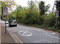
Your speed indicator in Almond Drive, Malpas, Newport
by Jaggery geograph for square ST3091 A 20mph speed limit is in force on the approach to Malpas Park Primary School.... (more)
|
|
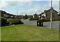
Louden Hill Road
by Richard Sutcliffe geograph for square NS6368 A residential street.
|
|
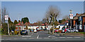
Baker Street near Tipton Green in Sandwell
by Roger D Kidd geograph for square SO9591 Looking north-east from near the junction with the A4123 Birmingham New Road.
|
|
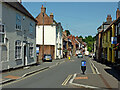
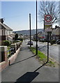
High Street in Kinver, Staffordshire
by Roger D Kidd geograph for square SO8483 Looking north-west towards the village centre.
Tags:
20 Zone
top:Business, Retail, ServicesX
type:GeographX
top:Housing, DwellingsX
top:Roads, Road TransportX
ShopsX
top:Village, Rural SettlementX
|
|
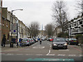
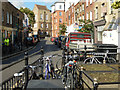
Globe Road, Bethnal Green
by Stephen McKay geograph for square TQ3582 Very much a part of the traditional East End, Globe Road runs north from Stepney... (more)
Tags:
20 Zone
BicyclesX
top:City, Town CentreX
top:Housing, DwellingsX
top:Roads, Road TransportX
subject:StreetX
StreetX
|
|
Studfield Road
by Alan Murray-Rust geograph for square SK3190 The sign suggests that this is the edge of the Wisewood housing estate.
Tags:
20 Zone
Housing DevelopmentX
top:Housing, DwellingsX
period:Inter-WarX
top:Roads, Road TransportX
Speed Restriction SignX
top:Suburb, Urban FringeX
Suburban RoadX
place:WisewoodX
|
|
Wigston Close
by Christine Johnstone geograph for square TQ3392 A private road through new housing on the north side of Wilbury Way.
|