Geograph - photograph every grid square
About tags on Geograph
Tags
Geographical Context
Subjects
Types
Other Prefixes
Public Tags
Related Tags
|
Coverage Map
Tag:
A1260
Other tags:
road:
A1260
Showing images tagged with
A1260
tag.
View all tagged images
-
In Browser
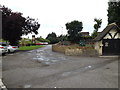
The Gordon Arms Public House car park
by
Geographer
geograph for square
TL1696
Off the A605 Oundle Road at the junction with the A1260 Nene Parkway... (
more
)
Tags:
A1260
A1260 Nene Parkway
X
A605
X
top:
Business, Retail, Services
X
subject:
Car Park
X
Car Park
X
type:
Geograph
X
Nene Parkway
X
at:
Orton Longueville
X
Orton Longueville
X
Oundle Road
X
Public House
X
Public House Car Park
X
Road Junction
X
top:
Roads, Road Transport
X
off:
The A605 Oundle Road
X
The Gordon Arms
X
The Gordon Arms Public House
X
The Gordon Arms Public House Car Park
X
at:
The Junction with the A1260 Nene Parkway
X
top:
Village, Rural Settlement
X
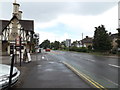
A605 Oundle Road, Orton Longueville
by
Geographer
geograph for square
TL1696
At the junction with the A1260 Nene Parkway near The Gordon Arms Public House
Tags:
A Road (Classified A)
X
A1260
A1260 Nene Parkway
X
A605
X
A605 Oundle Road
X
type:
Geograph
X
Nene Parkway
X
Orton Longueville
X
at:
Orton Longueville
X
Oundle Road
X
Public House
X
subject:
Road
X
top:
Roads, Road Transport
X
The Gordon Arms
X
near:
The Gordon Arms Public House
X
at:
The Junction with the A1260 Nene Parkway
X
top:
Village, Rural Settlement
X
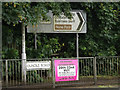
Roadsigns on the A605 Oundle Road
by
Geographer
for square
TL1696
At the junction with the A1260 Nene Parkway near The Gordon Arms Public House
Tags:
A Road (Classified A)
X
A1260
A1260 Nene Parkway
X
A605
X
A605 Oundle Road
X
Bridge
X
type:
Close Look
X
bucket:
Closeup
X
Nene Parkway
X
Nene Parkway Bridge
X
Orton Longueville
X
at:
Orton Longueville
X
Oundle Road
X
Public House
X
Road Junction
X
top:
Roads, Road Transport
X
Roadsigns
X
Roundabout
X
subject:
Sign
X
on:
The A605 Oundle Road
X
The Gordon Arms
X
The Gordon Arms Public House
X
near:
The Gordon Arms Public House
X
at:
The Junction with the A1260 Nene Parkway
X
top:
Village, Rural Settlement
X
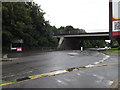
A605 Oundle Road & A1260 Nene Parkway Bridge
by
Geographer
geograph for square
TL1696
Near The Gordon Arms Public House
Tags:
A Road (Classified A)
X
A1260
A1260 Nene Parkway
X
A1260 Nene Parkway Bridge
X
A605
X
A605 Oundle Road
X
Bridge
X
type:
Geograph
X
Nene Parkway
X
Nene Parkway Bridge
X
Orton Longueville
X
at:
Orton Longueville
X
Oundle Road
X
Public House
X
subject:
Road Junction
X
Road Junction
X
top:
Roads, Road Transport
X
Roadsigns
X
Roundabout
X
The Gordon Arms
X
The Gordon Arms Public House
X
near:
The Gordon Arms Public House
X
top:
Village, Rural Settlement
X
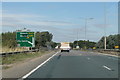
Nene Parkway (A1260) towards Peterborough centre
by
J.Hannan-Briggs
geograph for square
TL1697
About to cross the railway, near Orton Mere station.
Tags:
road:
A1260
place:
Peterborough
X
top:
Roads, Road Transport
X
A1260 towards Peterborough
by
J.Hannan-Briggs
geograph for square
TL1796
Tags:
road:
A1260
place:
Peterborough
X
top:
Roads, Road Transport
X
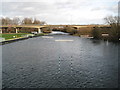
River Nene downstream of Orton Lock and Sluices
by
Nigel Cox
geograph for square
TL1697
There is a slalom course downstream of the sluices where canoeists can make use... (
more
)
Tags:
A1260
River Nene
X
top:
Rivers, Streams, Drainage
X
top:
Roads, Road Transport
X
Slalom Course
X
top:
Sport, Leisure
X
View more in the Image Search
or
in Browser
View images matching 'A1260' anywhere
in
the tags
Don't click these:
PotMel 1
PotMel 2
☰
Home
View
Search
Marked Images
Maps
Browser
Explore
Showcase
New Images
Collections
Interact
Games
Discussions
Blog
Contributors
Submit
Statistics
Leaderboards
General
FAQ
Help Pages
Sitemap
Contact Us
Support Us
sponsored by
🔍
What to search:
Photos
Enter keywords or a location/postcode to search nearby images
Enter a Grid Reference
Placenames
Collections
Website Pages
Everything
Others:
Advanced Search
|
Image Browser
Or:
Coverage Map
|
Searchable Map
You are not logged in
login
|
register