Public Tags
Tag: B6312
Showing images tagged with B6312 tag.
|
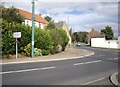
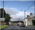
Front Street, Witton Gilbert
by Stanley Howe geograph for square NZ2345 B6312 bears left to Sacriston, past a Place of Worship (stone building in centre).
|
|
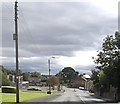
Sacriston Lane in Witton Gilbert
by Stanley Howe geograph for square NZ2345 B6312 about to bear right to join the A691.
|
|
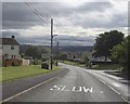
SLOW: B6312 entering Witton Gilbert
by Stanley Howe geograph for square NZ2346 Downhill from Sacriston.
|
|
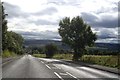
B6312 between Sacriston and Witton Gilbert
by Stanley Howe geograph for square NZ2346 A short downhill stretch without housing between the two former mining villages.
|
|
Sacriston crossroads
by Stanley Howe geograph for square NZ2446 Traffic light control; Robin Hood Inn on the right.
|