Public Tags
Tag: Beinn·Na·Caillich
Showing images tagged with Beinn Na Caillich tag.
|
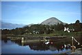
Beinn na Caillich
by Rude Health geograph for square NR4559 Beinn na Caillich, 332 metres and a hill with a prominence of 64 metres that is... (more)
|
|
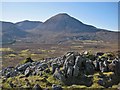
Beinn Dearg Bheag
by John Allan for square NG5921 The 582m summit seen from the ridge between Beinn na Caillich and Beinn Dearg Mhor.
|
|
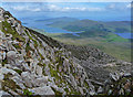
Beinn na Caillich west ridge
by Ian Taylor geograph for square NG5923 Looking SW over Coire Gorm, to Beinn Dearg Mhòr (right) and Beinn Dearg Bheag.... (more)
|
|
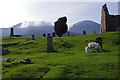
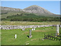
Graveyard at Cill Chriosd
by Ian Taylor geograph for square NG6120 Sheep graze whilst the mist rolls over Beinn Dearg Bheag (left) and Beinn na... (more)
|
|
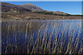
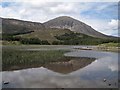
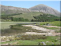
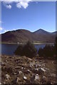
Loch Cill Chriosd
by Ian Taylor geograph for square NG6020 Beinn na Caillich is in the background.
|
|
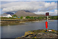
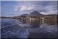
Old Pier, Broadford
by Ian Taylor geograph for square NG6423 The end of the pier with Beinn na Caillich in the background. The white building... (more)
|
|
New Pier, Corry
by Ian Taylor geograph for square NG6424 Also known as the Big Pier or MacKinnon's Pier. The pier had a wooden... (more)
|
|
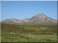
Beinn na Caillich and Coire Fearchair
by M J Richardson for square NG6023 Viewed from the east, from Broadford. The road is the B8083 to Elgol.
Tags:
Beinn Na Caillich
near:BroadfordX
type:Cross GridX
place:Isle of SkyeX
subject:MountainX
top:UplandsX
top:Village, Rural SettlementX
|
|
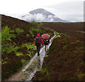
Path from Boreraig to Suardal
by Ian Taylor geograph for square NG6218 After climbing up from the shore, Beinn na Caillich comes into view.
|
|
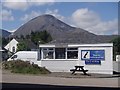
Tourist information centre with a visual prop
by Andrew Hill geograph for square NG6423 The little information centre in Broadford is overlooked by Beinn na Caillich,... (more)
|
|
Loch Cill Chriosd
by Richard Dorrell geograph for square NG6120 View across the loch to Beinn na Caillich from the shore just below the road... (more)
Tags:
place:Beinn Na Caillich
top:Lakes, Wetland, BogX
LochX
place:Loch Cill ChriosdX
near:TorrinX
top:UplandsX
|
|
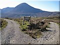
Choose your path
by Richard Dorrell geograph for square NG6221 To the left is the Marble Line path, which follows the line of the former... (more)
Tags:
place:Beinn Na Caillich
Footpath JunctionX
place:Isle of SkyeX
top:PathsX
place:Strath SuardalX
top:UplandsX
|
|
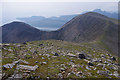
Towards Beinn na Caillich from Bheinn Shuardail
by Richard Dorrell geograph for square NG6221 Looking over Strath Suardal from the west facing slopes of the hill.
Tags:
place:Beinn Na Caillich
place:Bheinn ShuardailX
place:Isle of SkyeX
place:Strath SuardalX
top:UplandsX
|
|
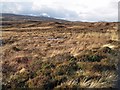
Heather moorland in winter
by Richard Dorrell geograph for square NG6819 This photograph is taken from a firm and dry part of the former A851, now... (more)
|
|
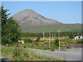
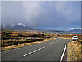
A851 towards Broadford
by Richard Dorrell geograph for square NG6722 The modern A851 was built in recent years replacing the earlier single-track... (more)
Tags:
road:A851X
Beinn Na Caillich
near:BroadfordX
place:Isle of SkyeX
top:Roads, Road TransportX
top:UplandsX
|
|
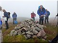
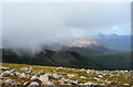
Summit of Beinn na Caillich
by John Allan geograph for square NG6023 The view northwards to the Red Hills, with a cloud base close to the 732m summit.
|
|
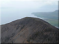
Coire Fearchair
by John Allan geograph for square NG6023 Farquhar's Coire is the eastern of the two coires of Beinn na Caillich. It... (more)
|
|
Beinn na Caillich
by M J Richardson for square NG6023 Looking across Strath Suardal from the Cill Chriosd burial ground.
Tags:
hill:Beinn Na Caillich
Burial GroundX
top:Burial Ground, CrematoriumX
type:Cross GridX
top:IslandsX
place:Isle of SkyeX
subject:MountainX
top:Rivers, Streams, DrainageX
top:Rocks, Scree, CliffsX
place:Strath SuardalX
top:UplandsX
top:Woodland, ForestX
|
|
Loch Cill Chriosd
by M J Richardson geograph for square NG6120 Looking across the shallow loch to Beinn na Caillich.
Tags:
Beinn Na Caillich
type:GeographX
top:GrasslandX
top:IslandsX
place:Isle of SkyeX
top:Lakes, Wetland, BogX
subject:LochX
Loch Cill ChriosdX
Strath SuardalX
top:UplandsX
top:Woodland, ForestX
|
|
Strath Suardal
by M J Richardson geograph for square NG6322 Looking across to Beinn na Caillich from the B8083 road to Elgol from Broadford.... (more)
|
|
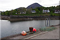
Piers, Broadford
by Richard Webb geograph for square NG6424 Tags:
p600 hill:Beinn Na Caillich
top:CoastalX
top:Docks, HarboursX
type:GeographX
top:Village, Rural SettlementX
|
|
Woodland, Scalpay
by Richard Webb geograph for square NG6027 Opposite Corran House on Skye.
|
|
Corry
by Richard Webb geograph for square NG6424 Skye seen from a boat bound for Scalpay.
|