Public Tags
Tag: Creag·Mhor
Other tags: p150 hill:Creag Mhor
Showing images tagged with Creag Mhor tag.
|
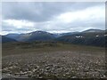
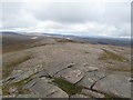
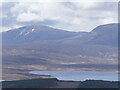
Creag Mhòr summit plateau
by Alan O'Dowd geograph for square NJ0504 The 895 metre-high Creag Mhòr is dwarfed by the higher Cairngorm peaks, some of... (more)
Tags:
top:Barren PlateauxX
CairngormsX
Creag Mhor
type:GeographX
subject:MountainsideX
Snow PatchesX
top:UplandsX
|
|
The eastern side of Creag Mhor
by Graham Robson geograph for square NJ0604 Looking down the eastern slope of Creag Mhor. The River Avon flows along the valley floor.
|
|
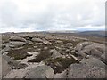
Exposed rocks on Creag Mhor
by Graham Robson geograph for square NJ0604 Exposed rocks, eroded into various interesting shapes to the east of the top of... (more)
|
|
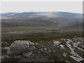
Looking south west from the top of Creag Mhor
by Graham Robson geograph for square NJ0504 Looking south west from the highest point of Creag Mhor across the barren top of... (more)
|
|
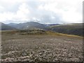
View south from the top of Creag Mhor
by Graham Robson geograph for square NJ0504 Looking south across the barren top of Creag Mhor.
|
|
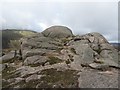
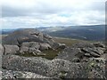
The summit of Creag Mhor
by Graham Robson geograph for square NJ0504 A rocky outcrop marks the undoubted summit of the top of Creag Mhor.
|
|
Approaching Creag Mhor
by Graham Robson geograph for square NJ0504 Approaching the summit of Creag Mhor by climbing straight up the flank of the... (more)
|
|
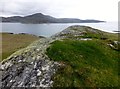
Creag Mhòr
by Rude Health geograph for square NL6695 Fourth coastal TuMP on Vatersay on a lovely morning with Iain Brown and Martin... (more)
|
|
View Towards Creag Mhòr From Eorsa
by Rude Health geograph for square NM4737 Eorsa north view towards Creag Mhòr.
|
|
Ben Armine
by Richard Webb for square NC6924 A distant view (they usually are) of this remote range from the north. Creag... (more)
Tags:
Ben ArmineX
p150 hill:Creag a Choire GhlaisX
p150 hill:Creag Mhor
type:Cross GridX
loch:Loch Nan ClarX
top:MoorlandX
top:Rocks, Scree, CliffsX
|
|
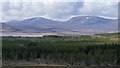
Forestry by Rimsdale
by Richard Webb for square NC7638 Ben Armine in the background. Creag Mhòr (left) and Creag a' Choire Ghlais (right).
Tags:
Ben ArmineX
p150 hill:Creag a Choire GhlaisX
p150 hill:Creag Mhor
type:Cross GridX
top:MoorlandX
top:Woodland, ForestX
|
|
Ben Armine above Muiemore
by Richard Webb geograph for square NC7719 View over Strath Skinsdale from Hope Hill to the two main Ben Armine summits.... (more)
Tags:
Ben ArmineX
BogX
p150 hill:Creag a Choire GhlaisX
p150 hill:Creag Mhor
type:GeographX
top:Lakes, Wetland, BogX
top:MoorlandX
|
|
View Northwest towards Ben Armine, Sutherland
by Andrew Tryon geograph for square NC7714 View from the flat summit plateau of Meall na h-Amaite (236m) towards Ben... (more)
|
|
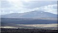
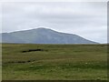
Ben Armine
by Richard Webb for square NC7024 The highest top of the extensive Ben Armine, Creag Mhòr seen from Tomich in the... (more)
|
|
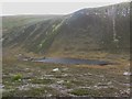
Looking down to Lochan a' Bhainne
by Graham Robson geograph for square NJ0404 Looking down to Lochan a' Bhainne from the slopes of Creag Mhor.
|
|
Summit tor on Creag Mhòr
by Alan O'Dowd geograph for square NJ0504 Looking towards mountainsides on the opposite side of Glen Avon.
|
|
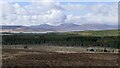
Loch Rimsdale and Ben Armine
by Richard Webb for square NC7435 The higher summit of Ben Armine (Creag Mhòr) with a snow patch.
Tags:
Ben ArmineX
p150 hill:Creag Mhor
type:Cross GridX
top:Lakes, Wetland, BogX
loch:Loch RimsdaleX
top:MoorlandX
top:Rocks, Scree, CliffsX
|
|
Bog and Ben Armine
by Richard Webb geograph for square NC7621 View over the endless peat of Strath Skinsdale towards Creag Mhòr of Ben Armine.
|
|
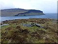
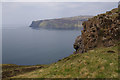
Creag Mhór
by Ian Taylor geograph for square NG4017 The south end of the crag. Looking across Loch Brittle.
|
|
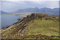
Creag Mhór
by Ian Taylor geograph for square NG4017 Loch Brittle is on the left, the Cuillin is in the background.
|
|
Strath Skinsdale and Ben Armine
by Richard Webb geograph for square NC7821 Time for a reminder - Ben Armine is a long range of hills in the wilds of... (more)
Tags:
Ben ArmineX
BogX
p150 hill:Creag a Choire GhlaisX
p150 hill:Creag Mhor
type:GeographX
top:Lakes, Wetland, BogX
top:MoorlandX
|
|
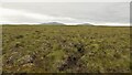
Near the summit of Cnoc Blàraich
by Richard Webb geograph for square NC7820 View towards Ben Armine from a rather rough flat bog which has a summit somewhere.
Tags:
Ben ArmineX
BogX
p150 hill:Creag a Choire GhlaisX
p150 hill:Creag Mhor
type:GeographX
top:Lakes, Wetland, BogX
top:MoorlandX
|
|
Bog and Ben Armine
by Richard Webb geograph for square NC7720 Strath Skinsdale, a vast bog east of Ben Armine.
Tags:
Ben ArmineX
BogX
p150 hill:Creag a Choire GhlaisX
p150 hill:Creag Mhor
type:GeographX
top:Lakes, Wetland, BogX
top:MoorlandX
|
|
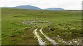
Ruined fank, Strath Skinsdale
by Richard Webb geograph for square NC7519 With Ben Armine in the background.
Tags:
Ben ArmineX
p150 hill:Creag a Choire GhlaisX
p150 hill:Creag Mhor
type:GeographX
top:MoorlandX
top:Roads, Road TransportX
|
|
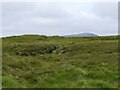
Bog, Strath Skinsdale
by Richard Webb geograph for square NC7622 View over a vast blanket bog towards the two highest summits of Ben Armine.... (more)
Tags:
Ben ArmineX
BogX
p150 hill:Creag a Choire GhlaisX
p150 hill:Creag Mhor
type:GeographX
top:Lakes, Wetland, BogX
top:MoorlandX
|
|
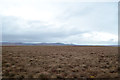
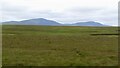
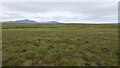
Strath Skinsdale
by Richard Webb geograph for square NC7721 A gentle rolling landscape of bog, hard going at times although usually friendly... (more)
Tags:
Ben ArmineX
BogX
p150 hill:Creag a Choire GhlaisX
p150 hill:Creag Mhor
type:GeographX
top:Lakes, Wetland, BogX
top:MoorlandX
|
|
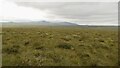
Bog and Ben Armine
by Richard Webb geograph for square NC7622 The Ben Armine scarp looms over the vast bogs of Strath Skinsdale.
Tags:
Ben ArmineX
BogX
CragX
p150 hill:Creag Mhor
type:GeographX
top:Geological InterestX
top:Lakes, Wetland, BogX
top:MoorlandX
top:Rocks, Scree, CliffsX
|
|
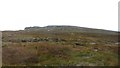
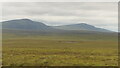
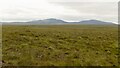
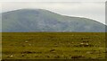
Moorland beneath Ben Armine
by Richard Webb geograph for square NC7520 Ben Armine's highest summit overlooking the bogs of Strath Skinsdale.
|