|
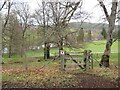
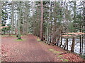
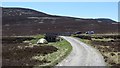
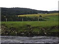
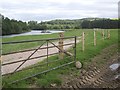
Path in the Balmoral Estate
by Malc McDonald
geograph for square NO2494
A gate onto path in the Balmoral Estate. The circular sign containing a red... (more)
|
|
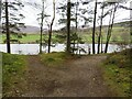
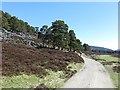
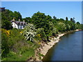
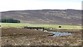
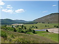
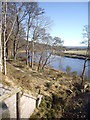
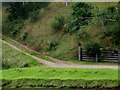
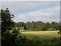
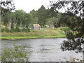
Path in the Balmoral Estate
by Malc McDonald
geograph for square NO2494
A path in Balmoral Estate leading to the bank of the River Dee.
|
|
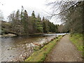
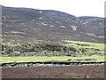
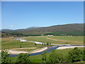
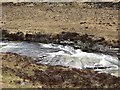
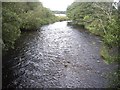
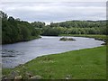
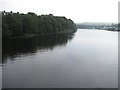
River Dee passing Balmoral
by Malc McDonald
geograph for square NO2595
A path alongside the River Dee as it flows past the Balmoral Estate.
|
|
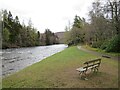
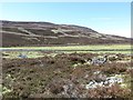
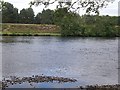
River Dee passing Balmoral
by Malc McDonald
geograph for square NO2595
A bench seat looking out over the River Dee as it flows past the Balmoral Estate.
|
|
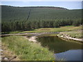
Riverside Walk, Balmoral Estate
by Malc McDonald
geograph for square NO2595
A path alongside the River Dee in the Balmoral Estate.
|
|
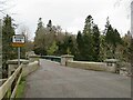
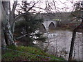
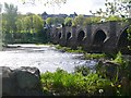
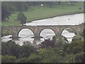
Bridge over the River Dee near Balmoral
by Malc McDonald
geograph for square NO2694
A bridge taking a minor road across the River Dee near the Balmoral Estate on... (more)
|
|
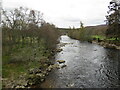
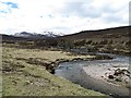
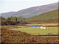
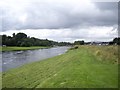
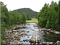
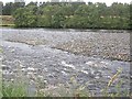
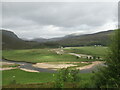
River Dee near Balmoral
by Malc McDonald
geograph for square NO2694
A view of the River Dee looking downstream near the Balmoral Estate, owned by... (more)
|
|
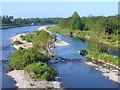
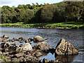
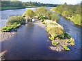
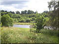
Aberdeen - River Dee
by Colin Smith
geograph for square NJ9203
Islets on the southern, slower flowing, side of the Dee just downstream from... (more)
|
|
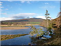
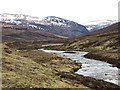
River Dee
by Richard Webb
geograph for square NO0188
Downstream of Chest of Dee.
|
|
River Dee
by Richard Webb
geograph for square NO0089
Looking up Glen Dee.
|
|
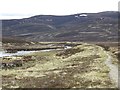
Road up the Dee
by Richard Webb
geograph for square NO0489
The road from Linn of Dee to White Bridge, Geldie and Bynack Lodges. The road... (more)
|
|
Banks of Dee, Banchory
by Colin Smith
geograph for square NO7095
East of The Platties, a popular riverside walk along the Dee between Banchory... (more)
|
|
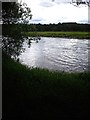
Aboyne - River Dee by Boat Inn
by Colin Smith
for square NO5298
North bank of the Dee just downstream of Aboyne Bridge.
|
|
Dee in spate, 31 Dec 2015
by Stanley Howe
geograph for square NO6097
Water in River Dee subsiding after a month of record rainfall which had caused... (more)
|
|
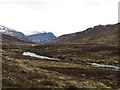
River Dee and Carn na Drochaide
by Alan O'Dowd
geograph for square NO1190
Looking across towards Allanaquoich from near the confluence of the Allt a'... (more)
|
|
Aberdeen - Riverside
by Colin Smith
geograph for square NJ9203
Grassy walkway on Riverside Drive by the River Dee between Brig o' Dee and... (more)
|
|
Aberdeen - Bridge of Dee
by Colin Smith
geograph for square NJ9203
Medieval bridge spanning the River Dee. This historic crossing is now closed to... (more)
|
|
Aberdeen - River Dee
by Colin Smith
geograph for square NJ9203
Shingly V-shaped inch below the south-eastern cutwaters of the Old Bridge of Dee.
|
|
Glen Dee
by Richard Webb
geograph for square NO0088
View towards Beinn Bhrotain along the Dee upstream of White Bridge.
|
|
Path beside the Dee
by Richard Webb
geograph for square NO0088
Once a road this is now a very good quality path. It does not link up with the... (more)
|
|
White Bridge
by Richard Webb
geograph for square NO0188
At the Geldie - Dee confluence, this is the first road crossing on the Dee.
|
|
White Bridge
by Richard Webb
for square NO0188
A crossing on the Dee, the road continuing into Glen Geldie where river crossing... (more)
|
|
Ruins, Dubrach
by Richard Webb
for square NO0288
Beside the Dee. There are now no longer any dwellings upstream of Linn of Dee.
|
|
Dalvorar
by Richard Webb
geograph for square NO0489
Haughs beside the Dee.
There is a ruined township here. A family was evicted... (more)
|
|
Looking upstream towards the Linn of Dee
by Alan O'Dowd
geograph for square NO1290
Part of the heathery hill of Creag Bhalg can be seen on the right of the photo.
|
|
The confluence of the Dee and the Quoich
by Alan O'Dowd
geograph for square NO1290
On distant Beinn a' Bhuird, a few snow patches still remain at the site... (more)
|
|
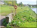
Confluence of Clunie Water and the River Dee
by Stanley Howe
geograph for square NO1492
Seen from the causeway riverside path approaching the River Dee.
|
|
Dalvorar
by Richard Webb
geograph for square NO0389
Ruined township on the south side of the Dee. A family was evicted from here in... (more)
|
|
River Dee near Heugh-head Wood
by Stanley Howe
geograph for square NO7196
Looking downstream (east) River Dee, from the Deeside Way bridge over the Bennie Burn.
|
|
Bridge of Dee from Tollohill
by Colin Smith
for square NJ9203
View of the medieval bridge, the historic gateway into Aberdeen from the south.... (more)
|
|
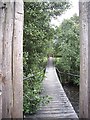
Suspended footbridge over an arm of the River Dee
by Stanley Howe
geograph for square NO5697
From an island in the River Dee.
|
|
View upstream River Dee
by Stanley Howe
geograph for square NO5498
From the track on the north bank of the Dee. Aboyne Sewage Farm is on the right... (more)
|
|
River Dee
by Richard Webb
geograph for square NO0088
A rapid where the river flows over rock slabs.
|
|
The River Dee from Invercauld Bridge (on the A93)
by David Purchase
geograph for square NO1891
The water is very low at present.
|
|
River Dee
by Stanley Howe
geograph for square NO5797
As seen from the Angling Club.
|
|
View south from the island near Dess
by Stanley Howe
geograph for square NO5697
Over the River Dee.
|
|
Right bank of River Dee
by Stanley Howe
geograph for square NO5697
Looking across from the island near Dess; Kinminity in the distance.
|
|
Downstream view from the footbridge over one arm of the River Dee
by Stanley Howe
geograph for square NO5697
|
|
Track from the south bank of the Dee
by Stanley Howe
geograph for square NO5597
Viewed from across the river.
|
|
River Dee, upstream of a shingle bank
by Stanley Howe
geograph for square NO5697
|
|
River Dee being divided by a shingle bank
by Stanley Howe
geograph for square NO5697
The right course being the faster flowing.
|
|
New riverside fence
by Stanley Howe
geograph for square NO5697
Near Big Jetty Pool on River Dee.
|
|
Islet in the River Dee
by Stanley Howe
geograph for square NO5697
Downstream of Big Jetty Pool.
|
|
Belwade farm
by Stanley Howe
geograph for square NO5598
Seen from by the River Dee.
|
|
FIshing bothy on north bank of River Dee
by Stanley Howe
geograph for square NO5697
Viewed from the track along the south bank, east end of Middle Belwade beat.
|
|
River Dee
by Richard Webb
geograph for square NJ9404
View upstream from Wellington Bridge.
|
|
Confluence of the Quoich and the Dee
by Alan O'Dowd
for square NO1190
A shower is passing through, on a day of sunshine and showers.
The snow... (more)
|
|
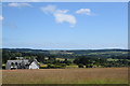
View of Treetops House and the Dee valley
by Bill Harrison
geograph for square NJ8504
|
|
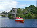
Lifeboat on the river Dee
by Stephen Craven
geograph for square NJ9404
This is a 'freefall' type lifeboat and belongs to Petrofac Training... (more)
|
|
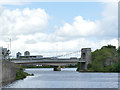
Wellington suspension bridge, Aberdeen
by Stephen Craven
geograph for square NJ9404
Looking downriver to the bridge, which was built in 1830 by engineer James... (more)
|