Public Tags
Tag: Gateway·(Disused)
Showing images tagged with Gateway (Disused) tag.
|
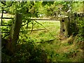
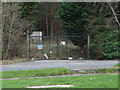
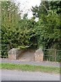
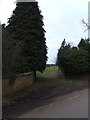
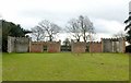
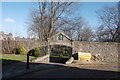
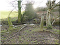
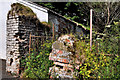
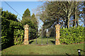
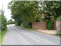
Disused gateway off Stony Lane, Southowram
by Humphrey Bolton geograph for square SE1224 The gateposts have large square holes for the insertion of wooden beams.
Tags:
top:Boundary, BarrierX
subject:GatewayX
Gateway (Disused)
Gateway to FieldX
type:GeographX
top:GrasslandX
top:LowlandsX
|
|
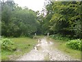
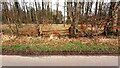
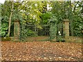
Islands Thorns Inclosure, disused gateway
by Mike Faherty geograph for square SU2216 At the northern end of the inclosure, which has been "thrown open" -... (more)
Tags:
top:Boundary, BarrierX
top:Derelict, DisusedX
subject:GatewayX
Gateway (Disused)
top:LowlandsX
top:Roads, Road TransportX
top:Woodland, ForestX
|
|
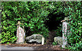
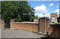
Old gateway, Brookhill near Lisburn
by Albert Bridge geograph for square J2066 A disused gateway to Brookhill, still retaining the imposing pillars, on the... (more)
|
|
Disused gateway, Lambeg
by Albert Bridge geograph for square J2766 A disused and overgrown gateway at the Lambeg Road end of Bells Lane. It was,... (more)
|
|
Transport Research Laboratory gateway
by Alan Hunt geograph for square SU8464 A disused gateway into the Transport Research Laboratory off the Old Wokingham Road.
|
|
Old Deco Style Gateway
by Des Blenkinsopp geograph for square TQ0672 Long disused but with that unmistakeable 1930s style which can still be found in... (more)
Tags:
architecture:1930sX
top:Derelict, DisusedX
Gateway (Disused)
type:GeographX
top:Suburb, Urban FringeX
|
|
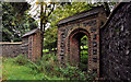
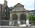
Edinburgh Meat Market Gateway, Fountainbridge
by kim traynor geograph for square NT2472 Category: Gateway The main entrance gateway to the old Edinburgh Meat Market in Fountainbridge... (more)
Tags:
top:City, Town CentreX
Gateway (Disused)
|
|
Wallingers Walk, Hastings
by PAUL FARMER geograph for square TQ8109 The bricked up gateway to the right is the former gateway to Castledown House
|
|
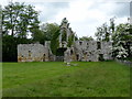
The Kent Gate, Bayham Old Abbey
by PAUL FARMER geograph for square TQ6436 Tags:
subject:AbbeyX
Abbey (Ruin)X
Abbey (Ruined)X
Abbey (Ruins)X
Abbey RuinX
Abbey RuinsX
place:Bayham AbbeyX
English HeritageX
English Heritage PropertyX
English Heritage SiteX
subject:GateX
GatewayX
subject:GatewayX
former:GatewayX
Gateway (Disused)
type:GeographX
subject:Historic BuildingX
top:Historic Sites and ArtefactsX
top:Religious SitesX
place:SussexX
SussexX
county:SussexX
|
|
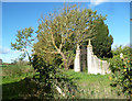
Yarnton Manor, West Gate
by Des Blenkinsopp geograph for square SP4711 This long disused gateway presumably used to open onto a drive or park at the... (more)
Tags:
top:Country EstatesX
Gateway (Disused)
|
|
Disused gateway to Markyate Cell
by John Lord geograph for square TL0516 Chimney of Markyate Cell Lodge visible above the trees.
Tags:
top:Country EstatesX
Gateway ( Disused)X
|
|
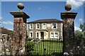
The Manor House, Stalbridge Lane
by Des Blenkinsopp geograph for square ST7615 A substantial old stone house with a carved coat of arms on the front.
Viewed... (more)
|
|
Bridge and gate at Manor Farm
by Alan Murray-Rust geograph for square SK7983 Currently disused and overgrown. Built as an entrance to Manor Farm around 1846... (more)
Tags:
FootbridgeX
subject:GatewayX
Gateway (Disused)
Grade II ListedX
top:PathsX
top:Rivers, Streams, DrainageX
|
|
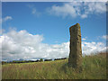
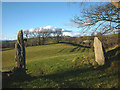
Old gatepost above Melling
by Karl and Ali geograph for square SD6070 Standing isolated like a prehistoric standing stone, even the wall that the... (more)
|
|
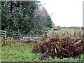
Closing an old gateway
by David Smith geograph for square SX7277 The left-hand gatepost in the stone wall is still visible, but the gateway has... (more)
|
|
Long-abandoned gates
by Richard Croft geograph for square SK5775 Rusting, long-disused gateposts and railings by Drinking Pit Lane on the Welbeck Estate
Tags:
top:Country EstatesX
top:Derelict, DisusedX
Gate (Disused)X
Gateway (Disused)
top:PathsX
long distance path:Robin HoodWayX
place:Sherwood ForestX
top:Woodland, ForestX
|
|
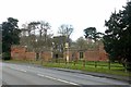
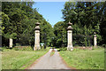
Entrance gateway to Hillersdon House
by David Smith geograph for square ST0007 Hillersdon House SS9907 : Cullompton: Hillersdon House is described in Pevsner and dates from the 1830s,... (more)
Tags:
top:Country EstatesX
Gateway (Disused)
|
|
Closed gateway
by Stephen Craven geograph for square TQ7259 Category: Entrance gates This gate would have given access to the sandpits west of Bull Lane but appeared... (more)
Tags:
Gateway (Disused)
top:Quarrying, MiningX
|
|
Former gateway into House Wood from east side of minor road
by Roger Templeman geograph for square NY5062 Tags:
Beech WoodlandX
Gateway (Disused)
type:GeographX
Grass VergeX
top:Roads, Road TransportX
Roadside HedgerowX
Rural RoadX
gateposts:StoneX
gate:WoodenX
top:Woodland, ForestX
|
|
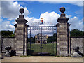
London Road gateway to Elvaston Castle
by Alan Murray-Rust geograph for square SK4031 View from the main road. This was the principal entrance to Elvaston Castle. The... (more)
Tags:
top:Boundary, BarrierX
top:Country EstatesX
period:Early 19th CenturyX
Gateway (Disused)
type:GeographX
Grade II ListedX
top:Historic Sites and ArtefactsX
|
|
London Road gateway to Elvaston Castle
by Alan Murray-Rust geograph for square SK4031 View from the rear showing the shells of the two lodges at either side. Listed... (more)
Tags:
top:Boundary, BarrierX
top:Country EstatesX
period:Early 19th CenturyX
Gateway (Disused)
type:GeographX
Grade II ListedX
top:Historic Sites and ArtefactsX
|
|
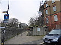
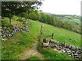
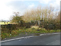
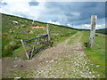
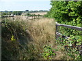
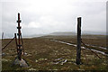
Gateway on Halifax Bridleway 181
by Humphrey Bolton geograph for square SE0427 |
|
Gateway on Halifax Bridleway 181
by Humphrey Bolton geograph for square SE0427 |
|
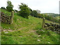
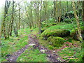
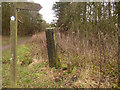
Old gateway on Hebden Royd FP119, Mytholmroyd
by Humphrey Bolton geograph for square SE0022 This goes through the wall, now ruined, between Knowl Wood and Higher House Wood.
Tags:
top:Boundary, BarrierX
Gateway (Disused)
top:LowlandsX
subject:PathX
top:PathsX
Public FootpathX
top:Woodland, ForestX
|
|
Old gateway to St Peter's Cemetery...
by Bill Harrison geograph for square NJ9407 ...off Spital. The entrance is now on King Street on the opposite side of the... (more)
Tags:
top:Boundary, BarrierX
top:Burial Ground, CrematoriumX
Gateway (Disused)
building material:GraniteX
Grit BoxX
WallX
|
|
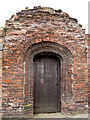
The Friary Gate, Beverley
by Stephen Craven for square TA0339 An adjacent plaque explains that this 16th century brick gateway from the nearby... (more)
Tags:
Abbey RuinsX
place:BeverleyX
top:City, Town CentreX
Gateway (Disused)
top:Historic Sites and ArtefactsX
|
|
Gateway, wall and path, Helen's Bay/Seahill
by Albert Bridge geograph for square J4482 See J4482 : Old entrance gate, Seahill (March 2008). A gateless arch, in a wall on the North Down... (more)
|
|
The Gates at Lodge Park
by Des Blenkinsopp geograph for square SP1412 Fancy gateway to this unusual National Trust place. Built for one John... (more)
|
|
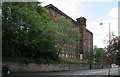
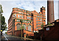
Big Mill, Mill Street façade
by Alan Murray-Rust geograph for square SJ9756 The building stands well above road level which makes its six-storey façade even... (more)
Tags:
style:Arts and CraftsX
top:Derelict, DisusedX
Gateway (Disused)
Grade II ListedX
top:IndustryX
style:ItalianateX
top:Roads, Road TransportX
disused:Silk MillX
top:Suburb, Urban FringeX
WallX
person:William SugdenX
|
|
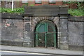
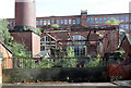
Former entrance to Big Mill
by Alan Murray-Rust for square SJ9756 Before the expansion of the mill to the rear, on top of the hill, these gates... (more)
Tags:
ArchX
top:Derelict, DisusedX
Gateway (Disused)
Grade II ListedX
top:IndustryX
top:PathsX
building material:SandstoneX
disused:Silk MillX
top:Suburb, Urban FringeX
person:William SugdenX
|
|
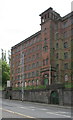
Big Mill, Mill Street façade
by Alan Murray-Rust geograph for square SJ9756 The building stands well above road level which makes its six-storey façade even... (more)
Tags:
top:Derelict, DisusedX
Gateway (Disused)
Grade II ListedX
top:IndustryX
style:ItalianateX
disused:Silk MillX
top:Suburb, Urban FringeX
TowerX
WallX
person:William SugdenX
|
|
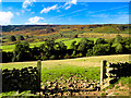
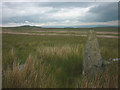
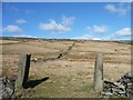
Rudland Rigg
by Scott Robinson geograph for square SE6695 The view towards Rudland Rigg across West Gill Beck
Tags:
top:Air, Sky, WeatherX
Dry Stone WallX
place:EnglandX
country:EnglandX
EnglandX
subject:FieldX
path:FootpathX
former:GatewayX
Gateway (Disused)
type:GeographX
subject:MoorlandX
MoorlandX
top:MoorlandX
National ParkX
North York MoorsX
North York Moors National ParkX
county:North YorkshireX
North YorkshireX
area:North YorkshireX
North Yorkshire MoorsX
area:North Yorkshire MoorsX
top:PathsX
Rudland RiggX
subject:SkyX
TreesX
top:UplandsX
ViewX
subject:ViewX
West GillX
top:Woodland, ForestX
|
|
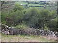
Pair of old stone gateposts
by Stephen Craven geograph for square SE2242 The beck is shown culverted at this point on older large scale maps, so... (more)
|
|
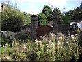
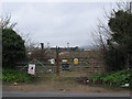
Old pumping station entrance
by Stephen Craven geograph for square SE2341 At the very south-east corner of the present Leeds-Bradford Airport site is this... (more)
Tags:
top:Boundary, BarrierX
top:Derelict, DisusedX
Gateway (Disused)
type:GeographX
Site of Former Water WorksX
|
|
Old gatepost near Keeper's Cottage
by Stephen Craven geograph for square SE2244 A former entrance into what was Caley Hall deer park (now part of Chevin Forest).
|
|
Old gatepost by the track over Old Moss
by Karl and Ali geograph for square SD7259 Its counterpart lies fallen in the rough grasses and moss. A small ruin lies... (more)
Tags:
top:Derelict, DisusedX
top:Farm, Fishery, Market GardeningX
Gateway (Disused)
top:MoorlandX
Stone GatepostX
top:UplandsX
|
|
Old gate near Edenderry, Belfast
by Albert Bridge for square J3168 A long-disused gate, with crumbling pillars, on the Edenderry Road.
|
|
Disused gate on the old road, Tintwistle
by Humphrey Bolton geograph for square SE1000 Tags:
CRoW Access LandX
Gateway (Disused)
type:GeographX
top:GrasslandX
top:PathsX
Restricted BywayX
subject:TrackX
top:UplandsX
|
|
Stone gateposts, Dawson Close
by Karl and Ali geograph for square SD6868 All traces of wall, fence or gates have disappeared from this abandoned and... (more)
|
|
Stone gateposts at Littlemire
by Karl and Ali geograph for square SD5396 Littlemire SD5396 : Ruin at Littlemire is an abandoned and ruined farmhouse; once this entrance... (more)
|
|
Gate to Banisters Farm
by Des Blenkinsopp geograph for square SU7762 Banisters must be a bit more than your usual farm to have a gate like this. It... (more)
|
|
Old gate at the edge of Broad Street
by Marathon geograph for square TQ7672 Hoo St Werburgh is one of the largest villages on the Hoo Peninsula and has far... (more)
Tags:
Gateway (Disused)
top:LowlandsX
|
|
Former college entrance off Lady Lane
by Stephen Craven geograph for square SE1140 These were the gates to the West Riding Teacher Training College SE1140 : Bingley College of Education 1975 that... (more)
|
|
Edge of a copse near Tiquhillie Castle
by Stanley Howe geograph for square NO7294 With a gated entrance that has seen better days!
Tags:
postcode area:AB31X
place:BanchoryX
CopseX
Gateway (Disused)
type:GeographX
subject:WoodlandX
Woodland EdgeX
top:Woodland, ForestX
|
|
Cotham Lane, Hawton
by Alan Murray-Rust geograph for square SK7850 The timber fencing (right) marks the old entrance to The Poplars (seen through... (more)
|
|
Swan Lane No.3 Mill - 14
by Alan Murray-Rust geograph for square SD7007 The (south-)western facade seen from Bridgeman Street.
Tags:
former:Engine HouseX
Factory ChimneyX
Gateway (Disused)
Grade II(star) Listed BuildingX
top:Historic Sites and ArtefactsX
top:IndustryX
top:Suburb, Urban FringeX
former:Textile MillX
|
|
Swan Lane Mills - 8
by Alan Murray-Rust geograph for square SD7007 Coal yard entrance, Bridgeman Street.
The two large windows belong to the... (more)
Tags:
former:Boiler HouseX
former:Engine HouseX
Factory ChimneyX
Gateway (Disused)
Grade II(star) Listed BuildingX
top:Historic Sites and ArtefactsX
top:IndustryX
top:Suburb, Urban FringeX
former:Textile MillX
|
|
Old gateposts near Goodbent Lodge
by Christine Johnstone geograph for square SE0807 A farm track once ran up the field boundary from Nether Lane to Springs Road.
|
|
Old gateposts on Carn nan Suilean Dubha
by Dorothy Carse geograph for square NH8211 On the line of an old fence at the top of the hill.
|
|
Ossington Hall gates
by Richard Croft geograph for square SK7664 Ossington Hall was built in 1729, enlarged c1790 and demolished in 1963. These... (more)
|