Public Tags
Tag: Gourock
Other tags: place:Gourock
Showing latest 50 of 195 images tagged with Gourock tag.
|
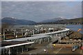
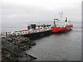
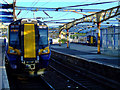
Gourock Train Station viewed from the upper deck of MV Bute at Gourock ferry terminal
by Garry Cornes geograph for square NS2477 A view of the train station at Gourock taken from the deck of the Calmac vessel... (more)
Tags:
CalmacX
CalMac FerryX
top:Docks, HarboursX
Ferry TerminalX
place:Gourock
subject:RailwayX
subject:Railway StationX
top:RailwaysX
TrainX
|
|
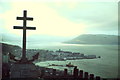
Gourock from Lyle Hill
by Colin Smith for square NS2477 Taken from the Lyle Hill viewpoint with its celebrated Cross of Lorraine, a Free... (more)
Tags:
top:City, Town CentreX
estuary:ClydeX
river:ClydeX
Cross of LorraineX
top:Defence, MilitaryX
top:Estuary, MarineX
Free FrenchX
place:Gourock
Memorial WWIIX
|
|
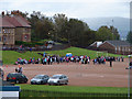
Gourock High School Sports Day
by Thomas Nugent geograph for square NS2376 The final sports day of Gourock High as the name will be lost when the school... (more)
|
|
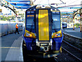
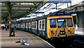
Right away at Gourock
by Thomas Nugent for square NS2477 New Class 380 train 380 103 gets the "right away" from Platform 1 at Gourock.
|
|
View north from the Kempock Stone, Gourock
by Christine Johnstone geograph for square NS2477 Until about 200 years ago, the 4,000 year old standing stone NS2477 : The Kempock stone, Burgh Walk, Gourock would... (more)
Tags:
top:City, Town CentreX
Firth of ClydeX
type:GeographX
place:Gourock
Slate RoofsX
subject:TownX
|
|
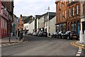
Kempock Street in Gourock
by Garry Cornes geograph for square NS2477 Kempock Street in Gourock is the main street that runs through the town and is... (more)
Tags:
top:Business, Retail, ServicesX
top:City, Town CentreX
top:CoastalX
place:Gourock
InverclydeX
PubX
top:Roads, Road TransportX
subject:StreetX
|
|
Gourock from the Firth
by James Allan for square NS2176 The west end of Gourock.
Tags:
top:City, Town CentreX
subject:CoastX
top:CoastalX
top:Estuary, MarineX
Firth of ClydeX
place:Gourock
|
|
Gourock ferry terminal
by M J Richardson geograph for square NS2176 On wet day - cars from Hunter's Quay leaving the ferry at Mc Inroy's Point.
Tags:
top:Air, Sky, WeatherX
Argyll and ButeX
top:CoastalX
subject:FerryX
Ferry TerminalX
place:Gourock
Gourock-Dunoon FerryX
top:Roads, Road TransportX
top:Village, Rural SettlementX
|
|
Ferry at McInroy's Point
by M J Richardson geograph for square NS2176 Western Ferries 'Sound of Scarba' from Hunter's Quay unloading at Gourock.
Tags:
Argyll and ButeX
top:Business, Retail, ServicesX
top:CoastalX
top:Estuary, MarineX
subject:FerryX
Ferry TerminalX
place:Gourock
Gourock-Dunoon FerryX
top:Roads, Road TransportX
top:Village, Rural SettlementX
Western FerriesX
|
|
Class 311 emu, Gourock
by Albert Bridge for square NS2477 Three-car class 311 no 311.101... (more)
|
![NS2477 : This way to Dunoon [and Kilcreggan] by Christine Johnstone](https://s3.geograph.org.uk/geophotos/06/21/14/6211471_84dbbd50_120x120.jpg)
|
This way to Dunoon [and Kilcreggan]
by Christine Johnstone geograph for square NS2477 The ferry terminal at Gourock.
|
|
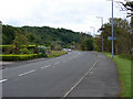
A770 Cloch Road Gourock
by Thomas Nugent geograph for square NS2176 Looking towards the site of the former Gantock Hotel, the Firth of Clyde is just... (more)
|
|
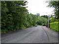
Cowal View
by Thomas Nugent geograph for square NS2276 Heading down the hill past Gourock Golf Club to Trumpethill.
|
|
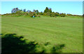
Field at Tower Hill
by Thomas Nugent geograph for square NS2377 Behind Gourock High School.
|
|
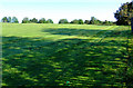
Field at Tower Hill
by Thomas Nugent geograph for square NS2377 Just over the fence from Gourock High School.
|

|
Class 380 train at Gourock
by Thomas Nugent for square NS2477 New Class 380 train 380 009 at Platform 1, about to depart for Glasgow Central.
|
|
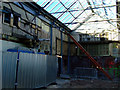
Reconstruction at Gourock railway station
by Thomas Nugent for square NS2477 Unfortunately the reconstruction has resulted in the destruction of most of the... (more)
|
|
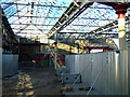
Reconstruction at Gourock railway station
by Thomas Nugent for square NS2477 Unfortunately the reconstruction has resulted in the destruction of most of the... (more)
|
|
Class 380 trains at Gourock
by Thomas Nugent geograph for square NS2477 380 103 is nearest the camera at Platform 1, 380 009 is just pulling into Platform 3.
|
|
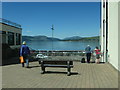
Admiring the view off Kempock Street, Gourock
by Christine Johnstone geograph for square NS2477 Not the car park on the sea shore, but the Firth of Clyde beyond.
Tags:
Bench SeatX
top:City, Town CentreX
Firth of ClydeX
type:GeographX
place:Gourock
subject:Open AreaX
ViewpointX
|
|
The Kempock stone, Burgh Walk, Gourock
by Christine Johnstone geograph for square NS2477 A 4,000 year old standing stone, now protected by railings. Someone carved their... (more)
Tags:
date:1814X
period:Bronze AgeX
type:GeographX
place:Gourock
top:Historic Sites and ArtefactsX
Iron RailingsX
subject:Standing StoneX
|
|
Houses on Burgh Walk and Bath Street, Gourock
by Christine Johnstone geograph for square NS2477 Late 20th century whitewashed terraces.
|
|
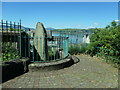
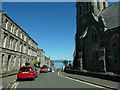
View down Bath Street, Gourock
by Christine Johnstone geograph for square NS2477 Towards the railway station and the Firth of Clyde.
Tags:
road:Bath StreetX
top:City, Town CentreX
Double Yellow LinesX
type:GeographX
place:Gourock
subject:StreetX
|
|
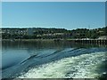
The shore of Gourock Bay, near Darroch Park
by Christine Johnstone geograph for square NS2477 Seen from a ferry departing for Dunoon.
|
|
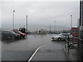
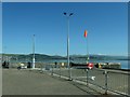
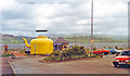
Windsock at the ferry terminal, Gourock
by Christine Johnstone geograph for square NS2477 On the far shore of the Firth of Clyde, the village of Kilcreggan, which is... (more)
|
|
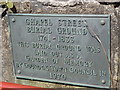
Chapel Street Burial Ground 1741 - 1833
by david cameron photographer for square NS2477 "This Burial Ground Was Laid Out As A Garden Of Memory
By Gourock Town... (more)
|
|
Kempock Point, Gourock and Watt's Kettle, 1994
by Ben Brooksbank geograph for square NS2477 View northward over Firth of Clyde to Kilcreggan on Roseneath peninsula, and... (more)
Tags:
top:CoastalX
top:Docks, HarboursX
top:Estuary, MarineX
Firth of ClydeX
Gourock
James WattX
top:People, EventsX
|
|
West Bay, Gourock
by James Allan geograph for square NS2377 Seen from a passing ship.
Tags:
top:City, Town CentreX
subject:CoastX
top:CoastalX
top:Estuary, MarineX
Firth of ClydeX
place:Gourock
|
|
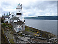
Cloch Lighthouse
by Thomas Nugent geograph for square NS2075 A famous landmark on the Firth of Clyde between Gourock and Inverkip.
Tags:
river:ClydeX
top:Docks, HarboursX
top:Estuary, MarineX
place:Gourock
LighthouseX
top:Rivers, Streams, DrainageX
top:Suburb, Urban FringeX
|

|
Swedish Navy vessel off Kirn
by Thomas Nugent for square NS1877 Swedish Navy minesweeper M74 HMS Kullen passing the Kirn/Dunoon boundary. Viewed... (more)
Tags:
river:ClydeX
top:Defence, MilitaryX
place:DunoonX
top:Estuary, MarineX
place:Gourock
top:Housing, DwellingsX
place:KirnX
top:Suburb, Urban FringeX
top:UplandsX
|
|
Cloch Lighthouse
by Thomas Nugent geograph for square NS2075 On the A770 Cloch Road between Gourock and Inverkip.
Tags:
top:Estuary, MarineX
place:Gourock
LighthouseX
top:PathsX
top:Roads, Road TransportX
top:Suburb, Urban FringeX
|
|
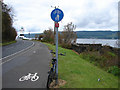
A770 Cloch Road Gourock
by Thomas Nugent geograph for square NS2176 At the west end of the town on the coast road to Inverkip.
|
|
Swedish Navy vessel off Kirn
by Thomas Nugent for square NS1878 Jim Crow rock NS1878 : Jim Crow can be seen just in front of the bow of Swedish Navy... (more)
Tags:
river:ClydeX
top:Defence, MilitaryX
top:Estuary, MarineX
place:Gourock
place:KirnX
top:Rivers, Streams, DrainageX
top:Suburb, Urban FringeX
top:UplandsX
|
|
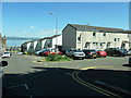
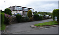
Blair Gardens
by Thomas Nugent geograph for square NS2176 1980s housing off Tantallon Avenue in Gourock.
|
|
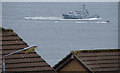
Swedish Navy vessel off Gourock
by Thomas Nugent for square NS2277 Minesweeper M74 HMS Kullen is being buzzed by an inflatable gun boat. A short... (more)
Tags:
river:ClydeX
top:Estuary, MarineX
place:Gourock
top:Housing, DwellingsX
top:IndustryX
top:Rivers, Streams, DrainageX
top:Suburb, Urban FringeX
|

|
Swedish Navy vessel off Gourock
by Thomas Nugent for square NS2277 Minesweeper M74 HMS Kullen is being buzzed by an inflatable gun boat. A short... (more)
Tags:
river:ClydeX
top:Defence, MilitaryX
top:Estuary, MarineX
place:Gourock
top:Rivers, Streams, DrainageX
|
|
Hunters Quay from Gourock
by Thomas Nugent for square NS1879 The ferry terminal and two Western Ferries can be seen in this view from Doune Gardens.
Tags:
river:ClydeX
top:Docks, HarboursX
top:Estuary, MarineX
place:Gourock
place:Hunters QuayX
place:KilcregganX
top:Rivers, Streams, DrainageX
top:UplandsX
top:Village, Rural SettlementX
|
|
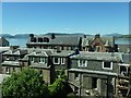
Firth of Clyde and Loch Long
by Thomas Nugent for square NS2276 Viewed over the rooftops from Doune Gardens in Gourock. The large shed at RNAD... (more)
Tags:
river:ClydeX
top:Defence, MilitaryX
top:Estuary, MarineX
place:Gourock
top:Rivers, Streams, DrainageX
top:UplandsX
|
|
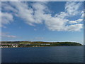
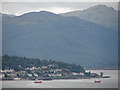
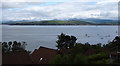
Firth of Clyde and Kilcreggan
by Thomas Nugent for square NS2480 The pier is visible on the right in this view from Turnberry Avenue in Gourock.
Tags:
river:ClydeX
top:Docks, HarboursX
top:Estuary, MarineX
top:Farm, Fishery, Market GardeningX
place:Gourock
place:KilcregganX
top:Rivers, Streams, DrainageX
top:Village, Rural SettlementX
top:Woodland, ForestX
|
|
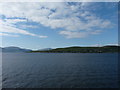
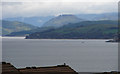
Firth of Clyde and Kilcreggan
by Thomas Nugent for square NS2380 Viewed from Turnberry Avenue in Gourock.
Tags:
river:ClydeX
top:Estuary, MarineX
top:Farm, Fishery, Market GardeningX
place:Gourock
top:Housing, DwellingsX
place:KilcregganX
top:Rivers, Streams, DrainageX
top:Village, Rural SettlementX
|
|
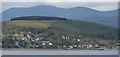
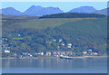
Firth of Clyde and Kilcreggan
by Thomas Nugent geograph for square NS2276 Viewed from Turnberry Avenue in Gourock.
Tags:
river:ClydeX
top:Estuary, MarineX
place:Gourock
top:Housing, DwellingsX
place:KilcregganX
top:Rivers, Streams, DrainageX
top:Suburb, Urban FringeX
top:UplandsX
|
|
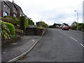
St Andrews Drive
by Thomas Nugent geograph for square NS2276 In Trumpethill, Gourock.
|
|
Barons Point and Loch Long
by Thomas Nugent for square NS2281 Barons Point is on the Rosneath Peninsula. Viewed from Cowal View in Gourock.
|

|
Strone and Strone Point
by Thomas Nugent for square NS1980 Viewed from Cowal View in Gourock.
Tags:
river:ClydeX
top:Estuary, MarineX
place:Gourock
top:Rivers, Streams, DrainageX
place:StroneX
top:UplandsX
top:Village, Rural SettlementX
|
|
|
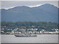
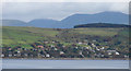
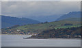
Firth of Clyde and Strone
by Thomas Nugent geograph for square NS2276 Viewed from Cowal View in Gourock.
Tags:
river:ClydeX
top:Estuary, MarineX
place:Gourock
top:Housing, DwellingsX
top:Rivers, Streams, DrainageX
place:StroneX
top:Suburb, Urban FringeX
top:UplandsX
|

|
Sign at Gourock Golf Club
by Thomas Nugent for square NS2276 Depicting the tower at Tower Hill in times gone by NS2377 : The tower on Tower Hill.
|
|
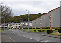
Cowal View
by Thomas Nugent geograph for square NS2276 At Gourock Golf Club. Trumpethill is in the distance.
Tags:
Golf ClubX
place:Gourock
top:Housing, DwellingsX
top:Roads, Road TransportX
top:Sport, LeisureX
|
|
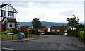
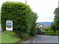
Gourock Golf Club
by Thomas Nugent geograph for square NS2276 The entrance and clubhouse on Cowal View.
Tags:
Golf ClubX
place:Gourock
top:Roads, Road TransportX
top:Sport, LeisureX
top:Suburb, Urban FringeX
|
|
Kilcreggan Bay and pier
by Thomas Nugent for square NS2480 Viewed from Tower Hill in Gourock.
Tags:
top:Docks, HarboursX
top:Estuary, MarineX
place:Gourock
place:KilcregganX
top:Rivers, Streams, DrainageX
top:UplandsX
top:Village, Rural SettlementX
|

|
The tower on Tower Hill
by Thomas Nugent geograph for square NS2377 A prominent landmark on the hill above Gourock.
|