Geograph - photograph every grid square
About tags on Geograph
Tags
Geographical Context
Subjects
Types
Other Prefixes
Public Tags
Related Tags
|
Coverage Map
Tag:
New·Fencing
Showing images tagged with
New Fencing
tag.
View all tagged images
-
In Browser
Search within these images
:
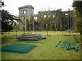
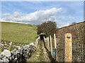
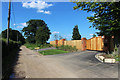
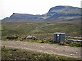
New fence at Craigend Castle
by
Richard Sutcliffe
geograph for square
NS5477
A new fence is being built around the ruined Craigend Castle to prevent people... (
more
)
Tags:
subject:
Castle
X
top:
Construction, Development
X
top:
Derelict, Disused
X
type:
Geograph
X
New Fence
X
top:
Park and Public Gardens
X
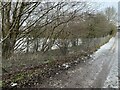
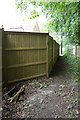
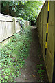
New fencing on Podmore Lane
by
Jonathan Hutchins
geograph for square
SJ7948
This is probably mainly to discourage the casual flytipping down the slope on the left.
Tags:
Bateswood Country Park
X
top:
Boundary, Barrier
X
subject:
Fencing
X
type:
Geograph
X
near:
Halmer End
X
New Fencing
top:
Roads, Road Transport
X
Trackside Fencing
X
Wire Mesh Fencing
X
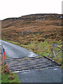
Cattle grid and a new fence
by
Richard Dorrell
geograph for square
NG1950
Category: Cattle grid
This is the little used 'old' road above Totaig. The deer fence... (
more
)
Tags:
Cattle Grid
X
Deer Fence
X
New Fence
X
Totaig
X
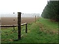
New fence, South Knowe
by
Jim Barton
geograph for square
NT2643
New fencing around the upper part of the Mailingsland Burn.
Tags:
Burn
X
type:
Geograph
X
Grassy Moorland with Bracken
X
top:
Moorland
X
New Fence
X
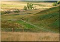
Footpath near Moor End
by
Adrian Taylor
geograph for square
NY7605
This public footpath is on railway property and on the railway side of the... (
more
)
Tags:
top:
Boundary, Barrier
X
county:
Cumbria
X
Cumbria
X
type:
Geograph
X
Litter
X
New Fence
X
subject:
Path
X
Path Barrier
X
top:
Paths
X
Post and Wire Mesh Fence
X
Public Footpath
X
Railway Boundary Wall
X
Railway Embankment
X
top:
Railways
X
Settle-Carlisle Railway
X
New Fence
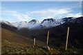
by
Michael Graham
geograph for square
NY1812
Forest edge fence near Scarth Gap. Hills left to right Brandreth, Green Gable,... (
more
)
Tags:
type:
Geograph
X
New Fence
X
top:
Rocks, Scree, Cliffs
X
top:
Uplands
X
top:
Woodland, Forest
X
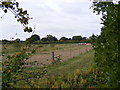
New fencing in a field off Reepham Road
by
Geographer
geograph for square
TG0524
Category: Field
Tags:
top:
Farm, Fishery, Market Gardening
X
subject:
Fencing
X
Field
X
at:
Mayfields
X
New Fencing
off:
Reepham Road
X
at:
Themelthorpe
X
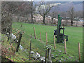
Fence post driver
by
Jim Barton
geograph for square
NT2438
A machine for driving in fence posts, used when mounted on a tractor. See also... (
more
)
Tags:
top:
Construction, Development
X
top:
Farm, Fishery, Market Gardening
X
Farmland
X
Fence Post Driver
X
type:
Geograph
X
New Fence
X
New Fence along the Lane
by
Des Blenkinsopp
geograph for square
SU8572
The last but one property along here before it becomes a path.
Tags:
type:
Geograph
X
New Fence
X
top:
Roads, Road Transport
X
Redneck Heath Thetford Forest
by
Keith Evans
geograph for square
TL8281
New fence at Redneck Heath near to Elveden, Suffolk. For similar view taken by... (
more
)
Tags:
top:
Farm, Fishery, Market Gardening
X
type:
Geograph
X
New Fence
X
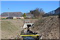
Realigned Nant Philkins, Sycamore Gardens
by
M J Roscoe
geograph for square
ST1898
The stream emerges now from a culvert (under construction
ST1898 : Pipes & pond on construction site
) under a... (
more
)
Tags:
top:
Boundary, Barrier
X
top:
Construction, Development
X
Culvert Outlet
X
type:
Geograph
X
New Fencing
top:
Rivers, Streams, Drainage
X
subject:
Stream
X
Stream Banks
X
top:
Suburb, Urban Fringe
X
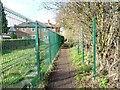
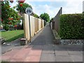
Public footpath to Tombridge Crescent
by
Christine Johnstone
geograph for square
SE4114
Cutting past back gardens, on the edge of Kinsley.
Tags:
path:
Footpath
X
Footpath
X
Garden Fence
X
New Fencing
top:
Paths
X
Public Footpath
X
Village Edge
X
Just in time...
by
Richard Dorrell
geograph for square
NG4372
My planned walk into the moorland just south of Conasta would have been more... (
more
)
Tags:
top:
Boundary, Barrier
X
near:
Conasta
X
place:
Isle of Skye
X
New Fencing
place:
Trotternish
X
place:
Trotternish Ridge
X
top:
Uplands
X
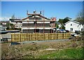
House extension
by
Richard Sutcliffe
geograph for square
NS6274
A house on Park Crescent, Torrance is being extended and refurbished.
Tags:
top:
Construction, Development
X
type:
Geograph
X
subject:
House
X
top:
Housing, Dwellings
X
New Fence
X
Scaffolding
X
Lovers Lane Footpath to Pouys Street
by
Geographer
geograph for square
TM3569
Off Pouys Street near Lane House Sibton Footpath No.1
Tags:
Footpath
X
type:
Geograph
X
near:
Lane House
X
Lovers Lane
X
Lovers Lane Footpath
X
Mill Hill
X
New Fence
X
subject:
Path
X
top:
Paths
X
off:
Pouys Street
X
at:
Sibton
X
top:
Village, Rural Settlement
X
Twitten between Glynde Close and Glynde Avenue
by
Peter Holmes
geograph for square
TQ0902
Public footpath 2120.
Tags:
Cherry Tree
X
type:
Geograph
X
top:
Housing, Dwellings
X
New Fence
X
No Cycling Sign
X
subject:
Path
X
top:
Paths
X
top:
Sport, Leisure
X
Lovers Lane Footpath to Mill Hill
by
Geographer
geograph for square
TM3569
Off Pouys Street near Lane House Sibton Footpath No.1
Tags:
Footpath
X
type:
Geograph
X
near:
Lane House
X
Lovers Lane
X
Lovers Lane Footpath
X
to:
Mill Hill
X
New Fence
X
subject:
Path
X
top:
Paths
X
off:
Pouys Street
X
at:
Sibton
X
Sibton Footpath No.1
X
top:
Village, Rural Settlement
X
View more in the Image Search
or
in Browser
View images matching 'New Fencing' anywhere
in
the tags
Don't click these:
PotMel 1
PotMel 2
☰
Home
View
Search
Marked Images
Maps
Browser
Explore
Showcase
New Images
Collections
Interact
Games
Discussions
Blog
Contributors
Submit
Statistics
Leaderboards
General
FAQ
Help Pages
Sitemap
Contact Us
Support Us
sponsored by
🔍
What to search:
Photos
Enter keywords or a location/postcode to search nearby images
Enter a Grid Reference
Placenames
Collections
Website Pages
Everything
Others:
Advanced Search
|
Image Browser
Or:
Coverage Map
|
Searchable Map
You are not logged in
login
|
register