Geograph - photograph every grid square
About tags on Geograph
Tags
Geographical Context
Subjects
Types
Other Prefixes
Public Tags
Related Tags
|
Coverage Map
Tag:
Pevensey·Level
Showing images tagged with
Pevensey Level
tag.
View all tagged images
-
In Browser
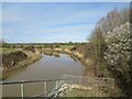
Pevensey Haven, Pevensey
by
Malc McDonald
geograph for square
TQ6405
Pevensey Haven, with Pevensey Levels in the background.
Tags:
Drain
X
county:
East Sussex
X
near:
Eastbourne
X
type:
Geograph
X
place:
Pevensey
X
river:
Pevensey Haven
X
Pevensey Levels
X
subject:
River
X
River
X
top:
Rivers, Streams, Drainage
X
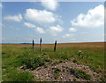
Pevensey Levels
by
PAUL FARMER
geograph for square
TQ6705
Picture take from Sluice Lane.
Tags:
top:
Flat Landscapes
X
subject:
Grassland
X
Grassland
X
top:
Grassland
X
Pevensey Levels
X
place:
Sussex
X
Sussex
X
Pevensey Levels
by
PAUL FARMER
geograph for square
TQ6705
Tags:
top:
Flat Landscapes
X
subject:
Grassland
X
Grassland
X
top:
Grassland
X
Pevensey Levels
X
Sussex
X
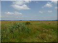
Pevensey Levels north of Pevensey, East Sussex
by
nick macneill
geograph for square
TQ6405
Category: Levels (wetland)
Tags:
top:
Lakes, Wetland, Bog
X
Pevensey Level
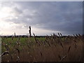
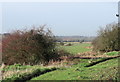
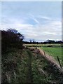
Pevensey Levels south of Hooe, East Sussex
by
nick macneill
geograph for square
TQ6708
Category: Levels (wetland)
A crow enters stage right, a rabbit is below it to the left and in the distance... (
more
)
Tags:
top:
Grassland
X
Pevensey Level
Rabbit
X
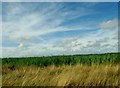
Big skies over Pevensey Levels
by
nick macneill
geograph for square
TQ6208
Tags:
top:
Flat Landscapes
X
top:
Lakes, Wetland, Bog
X
Pevensey Levels
X
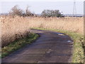
Road to Pylons Farm, Pevensey Levels, East Sussex
by
nick macneill
geograph for square
TQ6507
Category: Road
Tags:
Pevensey Levels
X
top:
Roads, Road Transport
X
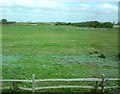
Field near Pevensey Bay
by
Gerald England
geograph for square
TQ6403
The field is often used for car boot sales.
Tags:
Car Boot Sales Site
X
top:
Farm, Fishery, Market Gardening
X
top:
Flat Landscapes
X
type:
Geograph
X
place:
Pevensey Bay
X
Pevensey Levels
X
Footpath near Pevensey Castle
by
PAUL FARMER
geograph for square
TQ6403
Tags:
Footpath
X
path:
Footpath
X
type:
Geograph
X
subject:
Path
X
top:
Paths
X
Pevensey
X
Pevensey Levels
X
Drain near Pevensey
by
nick macneill
geograph for square
TQ6405
Tags:
Drain
X
top:
Flat Landscapes
X
place:
Pevensey Bay
X
Pevensey Levels
X
top:
Rivers, Streams, Drainage
X
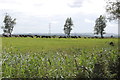
Grazing Cows on the Levels, near Wartling
by
Julian P Guffogg
geograph for square
TQ6408
Tags:
Cows
X
top:
Farm, Fishery, Market Gardening
X
top:
Grassland
X
Pevensey Levels
X
near:
Wartling
X
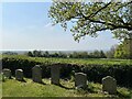
View from Wartling churchyard
by
Jonathan Hutchins
geograph for square
TQ6509
Tags:
top:
Burial Ground, Crematorium
X
subject:
Churchyard
X
Churchyard Headstones
X
type:
Geograph
X
Pevensey Levels
X
top:
Religious Sites
X
top:
Village, Rural Settlement
X
place:
Wartling
X
View more in the Image Search
or
in Browser
View images matching 'Pevensey Level' anywhere
in
the tags
Don't click these:
PotMel 1
PotMel 2
☰
Home
View
Search
Marked Images
Maps
Browser
Explore
Showcase
New Images
Collections
Interact
Games
Discussions
Blog
Contributors
Submit
Statistics
Leaderboards
General
FAQ
Help Pages
Sitemap
Contact Us
Support Us
sponsored by
🔍
What to search:
Photos
Enter keywords or a location/postcode to search nearby images
Enter a Grid Reference
Placenames
Collections
Website Pages
Everything
Others:
Advanced Search
|
Image Browser
Or:
Coverage Map
|
Searchable Map
You are not logged in
login
|
register