Public Tags
Tag: Quantocks
Showing images tagged with Quantocks tag.
|
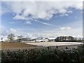
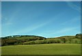
Dusting of snow over the Quantock Hills
by Marika Reinholds geograph for square ST1334 Distant view of the Quantock Hills. Taken from Station Road, Crowcombe Heathfield.
Tags:
top:Air, Sky, WeatherX
place:Crowcombe HeathfieldX
type:GeographX
top:Heath, ScrubX
subject:HillX
HillsideX
Quantock HillsX
Quantocks
weather:SnowX
SnowX
Snow SceneX
top:UplandsX
top:Village, Rural SettlementX
top:Woodland, ForestX
|
|
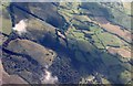
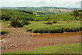
Little Quantock from the air
by Derek Harper for square ST1436 Fields slope away on the southwest side of the summit ridge. Just beyond the two... (more)
|
|
View of Quantocks near Carhampton
by nick macneill geograph for square ST0142 |
|
Black Hill, Quantocks
by Derek Harper geograph for square ST1438 Taken from the same spot as ST1438 : Head of Frog Combe, looking to the left along the ridge... (more)
|
|
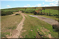
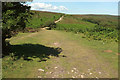
Moorland at Halsway Post
by Derek Harper geograph for square ST1438 Something of a focal point on the Quantocks, with several bridleways meeting.... (more)
|
|
Stert Combe, Quantocks
by Derek Harper geograph for square ST1438 Wooded combes join in this view looking left from ST1438 : Black Hill. The nearer is... (more)
|
|
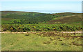
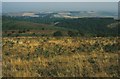
Moorland on Frog Hill
by Derek Harper geograph for square ST1538 Looking right from ST1538 : Bridleway on Frog Hill from high on the Quantocks towards the Bristol... (more)
|
|
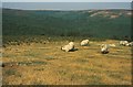
Sheep on Higher Hare Knapp
by Derek Harper geograph for square ST1439 On a ridgetop summit in the Quantocks, looking towards and across Somerton Combe... (more)
|
|
Thorncombe Hill near Crowcombe
by nick macneill for square ST1338 |
|
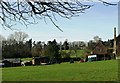
Sloped field near Nether Stowey
by nick macneill geograph for square ST1739 Tags:
top:Farm, Fishery, Market GardeningX
Quantocks
|
|
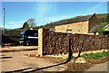
Cothelstone Farm, Cothelstone
by nick macneill geograph for square ST1831 |
|
Cothelstone Farm, Cothelstone
by nick macneill geograph for square ST1831 |
|
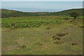
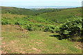
View from Higher Hare Knapp
by Derek Harper geograph for square ST1439 Looking down the ridge towards Holford Combe.
|
|
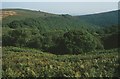
Head of Frog Combe
by Derek Harper geograph for square ST1438 From a bridleway on Black Hill. The combe quickly crosses into ST1538. On... (more)
Tags:
plant:BrackenX
top:Heath, ScrubX
HeathlandX
top:LowlandsX
Quantocks
Wooded ValleyX
top:Woodland, ForestX
|
|
Track on Frog Hill
by Derek Harper geograph for square ST1538 A bridleway follows this track from the junction north of ST1538 : Wilmot's Pool, Quantock Hills across... (more)
|
|
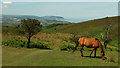
By Bicknoller Post
by Derek Harper geograph for square ST1240 A pony grazes just northwest of the actual post. In the distance is Minehead.
|
|
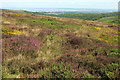
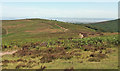
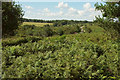
Heather on Thorncombe Hill
by Derek Harper geograph for square ST1339 Bell heather (Erica cinerea) and gorse in flower by an upper track above the... (more)
Tags:
Access LandX
plant:Bell HeatherX
estuary:Bristol ChannelX
top:Energy InfrastructureX
top:Estuary, MarineX
type:GeographX
plant:GorseX
top:Heath, ScrubX
top:MoorlandX
MoorlandX
Nuclear Power Station Under ConstructionX
Quantocks
top:UplandsX
ViewX
WoodsX
|
|
At Lowsey Thorn
by Derek Harper geograph for square ST1338 Looking right from ST1338 : Lowsey Thorn towards Slaughterhouse Combe.
|
|
Lowsey Thorn
by Derek Harper geograph for square ST1338 The Macmillan Way West, following bridleway WL 8/1, crosses a dip (a puddle is... (more)
|
|
Halsway Post
by Derek Harper geograph for square ST1438 Also shown at Link . The angle of... (more)
|
|
Macmillan Way West at Halsway Post
by Derek Harper geograph for square ST1438 Looking right from ST1438 : Moorland at Halsway Post. The Way follows bridleway WL 10/31 up... (more)
|
|
Puddle on bridleway near Halsway Post
by Derek Harper geograph for square ST1438 Bridleway WL 10/31 heading east from Halsway Post. Bell heather is conspicuously... (more)
|
|
Black Hill
by Derek Harper geograph for square ST1438 A ridge carrying a bridleway towards Higher Hare Knap, between Somerton Combe... (more)
Tags:
Access LandX
plant:BrackenX
BridlewayX
estuary:Bristol ChannelX
CombesX
top:Energy InfrastructureX
type:GeographX
plant:HeatherX
MoorlandX
top:MoorlandX
Nuclear Power Station (Disused)X
Nuclear Power Station Under ConstructionX
top:PathsX
Quantocks
RidgeX
top:UplandsX
top:Woodland, ForestX
WoodsX
|
|
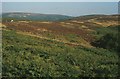
Near the head of Frog Combe
by Derek Harper geograph for square ST1538 The tree beside me can be seen by the bridleway in the dip seen in... (more)
|
|
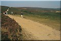
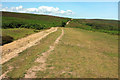
Bridleway on Frog Hill
by Derek Harper geograph for square ST1538 Bridleway WL 10/31 descending to cross the head of Frog Combe.
|
|
Bridleway on Frog Hill
by Derek Harper geograph for square ST1538 Bridleway WL 10/31 seen more or less at the same point 26 years after... (more)
|
|
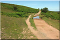
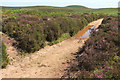
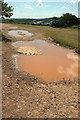
Puddle, Frog Hill
by Derek Harper geograph for square ST1538 The track arrives at the car park near Wilmot's Pool.
|
|
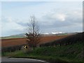
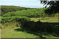
From Withyman's Pool car park
by Derek Harper geograph for square ST1538 With a glimpse of the road to Crowcombe across the bracken.
Tags:
Access LandX
plant:BrackenX
type:GeographX
Grass FieldX
top:Heath, ScrubX
Quantocks
top:Roads, Road TransportX
TreesX
Unfenced RoadX
top:UplandsX
|
|
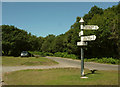
Car park and signpost. Dead Woman's Ditch
by Derek Harper geograph for square ST1638 The signpost is also shown in ST1638 : Signpost. Dead Woman's Ditch.
Tags:
Access LandX
Car ParkX
type:GeographX
top:GrasslandX
Quantocks
top:Roads, Road TransportX
Roadside VergeX
SignpostX
Unfenced RoadX
top:UplandsX
WoodX
top:Woodland, ForestX
|
|
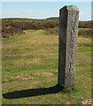
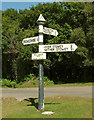
Signpost. Dead Woman's Ditch
by Derek Harper for square ST1638 Also shown at ST1638 : Dead Woman's Ditch Crossroads. Across the road is woodland on Robin Upright's Hill.
Tags:
Access LandX
type:Close LookX
Quantocks
top:Roads, Road TransportX
Roadside VergeX
SignpostX
Unfenced RoadX
top:UplandsX
WoodX
top:Woodland, ForestX
|