Public Tags
Tag: Scottish/English·Border
Showing latest 50 of 51 images tagged with Scottish/English Border tag.
|
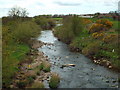
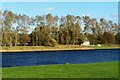
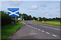
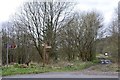
The England-Scotland border at Gretna
by Malc McDonald geograph for square NY3266 The River Sark forms the border between England and Scotland at Gretna. In this... (more)
|
|
Bridge into Scotland at Gretna
by Malc McDonald geograph for square NY3266 Cars and a pedestrian crossing the River Sark from Scotland into England. The... (more)
|
|
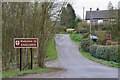
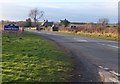
B7076 road entering England
by Malc McDonald geograph for square NY3266 The B7076 road crosses the border from Scotland into England as it crosses the... (more)
|
|
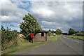
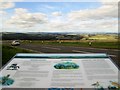
Border burger bar at Carter Bar
by Steve Fareham geograph for square NT6906 |
|
Scottish border
by David Chatterton geograph for square NT9452 Not much to look at, but this is the point where the England/Scotland border... (more)
Tags:
BorderX
Borders RegionX
top:Boundary, BarrierX
top:LowlandsX
National BorderX
top:Rivers, Streams, DrainageX
Scottish- English BorderX
river:TweedX
|
|
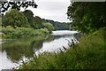
England/Scotland border
by David Chatterton geograph for square NT9249 The border runs down the centre of the River Tweed, mostly, anyway. According to... (more)
|
|
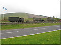
Army convoy at Carter Bar, English-Scottish border
by David Hawgood geograph for square NT6906 The convoy of lorries, some towing field guns, stopped briefly in the Northbound... (more)
|
|
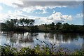
A tranquil scene at the Border
by Jim Barton geograph for square NT9350 The Scottish-English border runs along the centreline of the Tweed here.
Tags:
top:Boundary, BarrierX
type:GeographX
top:Rivers, Streams, DrainageX
Riverside WoodsX
Scottish- English BorderX
river:TweedX
top:Woodland, ForestX
|
|
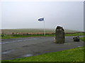
Border stone, Carter Bar
by Alan Murray-Rust geograph for square NT6906 The Scottish flag is actually being flown on English ground.
|
|
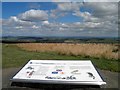
Scotland's Border country information board
by Steve Fareham geograph for square NT6906 |
|
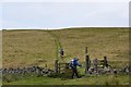
Approaching the Scottish Border
by Jim Barton geograph for square NT9453 The border follows the track coming in from the left and heads north along the... (more)
Tags:
top:Boundary, BarrierX
FarmlandX
type:GeographX
Minor RoadX
top:PathsX
top:Roads, Road TransportX
Scottish/English Border
TrackX
|
|
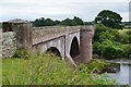
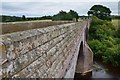
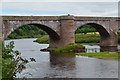
Ladykirk and Norham Bridge over the Tweed
by Jim Barton geograph for square NT8847 The English - Scottish border follows the Tweed hereabouts and crosses the... (more)
|
|
The border - Scotland vs England
by M J Richardson for square NT9757 Looking down at the A1 from Lamberton. The border crosses the road at the flags... (more)
Tags:
BerwickshireX
top:Boundary, BarrierX
top:Farm, Fishery, Market GardeningX
near:Lamberton HoldingsX
top:LowlandsX
top:Roads, Road TransportX
place:Scottish BordersX
Scottish/English Border
|
|
A6105 Duns Road at Clappers
by Mat Fascione geograph for square NT9455 The border of Northumberland in England and the Scottish Borders in Scotland.
|
|
Scottish border sign at Ladykirk and Norham Bridge
by Jim Barton geograph for square NT8847 On the left is the first (or last) car park in Scotland, depending on your... (more)
|
|
Scotland/England Border on the Berwickshire Coastal Path
by Mat Fascione geograph for square NT9757 The Berwickshire Coastal Path stretches for about 48 kilometres (38 miles) from... (more)
|
|
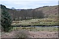
Kershopefoot
by Jim Barton geograph for square NY4782 A Border hamlet at the confluence of the Kershope Burn and the Liddel Water. The... (more)
|
|
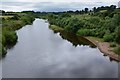
The English side of the Tweed
by Jim Barton geograph for square NT8947 A view upstream from Ladykirk and Norham Bridge from the pedestrian refuge half... (more)
|

|
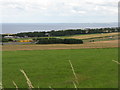
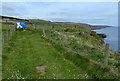
West In Thirle from Pettico Wick
by Andy Stephenson geograph for square NT9069 According to Wikipedia, Pettico Wick Bay provides a natural trap for salmon as... (more)
Tags:
subject:CliffX
Cliff SceneryX
top:CoastalX
top:Estuary, MarineX
type:GeographX
top:Geological InterestX
Near St AbbsX
top:Rocks, Scree, CliffsX
place:Scottish BordersX
Scottish/English Border
near:St AbbsX
place:St Abbs HeadX
|
|
Berwickshire Coastal Path enters Scotland
by Mat Fascione geograph for square NT9757 The Berwickshire Coastal Path stretches for about 48 kilometres (38 miles) from... (more)
|
|
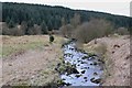
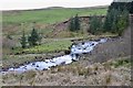
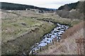
Kershope - the border burn
by Jim Barton geograph for square NY5184 The burn hereabouts separates Scotland (R) from England (L), though in days gone... (more)
Tags:
top:Boundary, BarrierX
BurnX
Conifer PlantationX
type:GeographX
top:MoorlandX
top:Rivers, Streams, DrainageX
Scottish- English BorderX
top:Woodland, ForestX
|
|
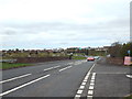
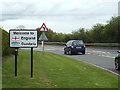
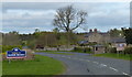
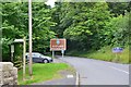
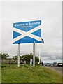
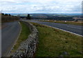
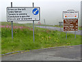
Welcome to Scotland sign on the A7 road, near Scotsdike, Dumfries & Galloway
by P L Chadwick geograph for square NY3873 As the years roll by the design of this sign, slightly north of the border... (more)
Tags:
top:Boundary, BarrierX
type:GeographX
top:Roads, Road TransportX
Scottish/English Border
SignsX
|
|
Border Bus Shelter
by Des Blenkinsopp geograph for square NT9455 The Starch House Crossroads bus shelter by the crossroads where the A 6105... (more)
Tags:
road:A RoadX
top:Boundary, BarrierX
Bus ShelterX
type:GeographX
top:Roads, Road TransportX
Scottish- English BorderX
|
|
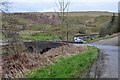
Border bridge over the Kershope Burn
by Jim Barton geograph for square NY5184 An FC barrier resembling a border control at the exit from Newcastleton Forest,... (more)
|
|
The Tweed and Kippie Island
by Jim Barton geograph for square NT8844 To the left, Kippie Island (Scotland) merges upstream into Dreeper Island... (more)
|
|
Road junction on the Border
by Barbara Carr geograph for square NT9455 Looking from 'no man's land' into Scotland - cf NT9455 : Road junction on the Border.
|
|
Where am I?
by Barbara Carr geograph for square NT9453 The Border runs along this road, seemingly to the east - so, standing... (more)
|
|
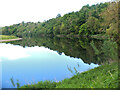
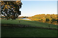
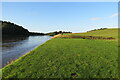
View from our holiday cottage on the Milne Graden Estate
by Martin Dawes geograph for square NT8845 Early morning over the River Tweed. If you wished, the riverside footpath takes... (more)
Tags:
top:Air, Sky, WeatherX
top:Country EstatesX
type:GeographX
top:LowlandsX
Milne Graden EstateX
top:PathsX
Scottish- English BorderX
river:TweedX
top:Woodland, ForestX
|
|
Kershope Bridge
by Jim Barton geograph for square NY5083 A cross-border bridge on the minor road SE from Newcastleton.
Tags:
top:Boundary, BarrierX
BurnX
type:GeographX
Minor Road BridgeX
top:MoorlandX
top:Rivers, Streams, DrainageX
top:Roads, Road TransportX
Scottish- English BorderX
|
|
Two large rocks either side of the A68 The Border
by Martin Dawes geograph for square NT6906 England on this side Scotland on the other side, I am looking toward England
Tags:
top:Boundary, BarrierX
place:Carter BarX
top:GrasslandX
top:Roads, Road TransportX
Scottish/English Border
top:UplandsX
|
|
The border no turning back now
by Martin Dawes geograph for square NT6906 A number of languages were being spoken in the car park, the tourist trade
Tags:
top:Boundary, BarrierX
place:Carter BarX
top:Roads, Road TransportX
Scottish/English Border
top:UplandsX
|
|
ENGLAND - hiding its light behind a bushel
by M J Richardson for square NT9452 Border sign on the B6461 at Paxton Toll. It was more visible two months earlier... (more)
Tags:
subject:BoundaryX
top:Boundary, BarrierX
top:LowlandsX
near:PaxtonX
top:Roads, Road TransportX
Scottish/English Border
|
|
Gateway to England, St Cuthbert's Way
by Jim Barton geograph for square NT8527 The Border crossing on the route from Kirk Yetholm to Wooler.
Tags:
top:Boundary, BarrierX
Footpath SignpostX
GateX
top:MoorlandX
top:PathsX
Scottish- English BorderX
St. Cuthberts WayX
top:UplandsX
|
|
Kershope Burn
by Jim Barton geograph for square NY5084 The burn from the English side, looking across to the slopes of Blinkbonny Height.
Tags:
top:Boundary, BarrierX
BurnX
type:GeographX
Grassy HillsideX
top:MoorlandX
top:Rivers, Streams, DrainageX
Scottish- English BorderX
|
|
Ladykirk and Norham Bridge over the Tweed (2)
by Jim Barton geograph for square NT8947 The east side of the bridge and the English bank of the Tweed near Norham, seen... (more)
|
|
Scotland. Over the information board
by Martin Dawes geograph for square NT6906 The A68 heading for the zig zags down the hill
Tags:
road:A RoadX
place:Carter BarX
type:GeographX
Information BoardX
top:LowlandsX
top:Roads, Road TransportX
Scottish/English Border
|
|
The A68 Road at Carter Bar
by Mat Fascione geograph for square NT6906 |
|
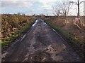
Path along disused railway, Kershopefoot
by Jim Barton geograph for square NY4782 Footpath sign indicating the path to Newcastleton on the old Waverley route from... (more)
Tags:
top:Derelict, DisusedX
Footpath SignpostX
Former Railway RouteX
type:GeographX
top:PathsX
top:RailwaysX
Scottish- English BorderX
|
|
Kershope Burn downstream of the bridge
by Jim Barton geograph for square NY4983 The burn winds its way down a grassy valley with Kershope Forest on the south side.
Tags:
top:Boundary, BarrierX
BurnX
type:GeographX
top:MoorlandX
top:Rivers, Streams, DrainageX
Scottish- English BorderX
top:Woodland, ForestX
|
|
Ladykirk and Norham Bridge over the Tweed (3)
by Jim Barton for square NT8947 The central spans of this four-span bridge that dates from 1887. The figure... (more)
|
|
Drive on the left
by Alan Murray-Rust geograph for square NT6906 Chris Downer shot the same sign six years ago... (more)
Tags:
place:Carter BarX
weather:Low CloudX
Road SignsX
top:Roads, Road TransportX
Scottish- English BorderX
|
|
Haar on Caarter Baar
by Alan Murray-Rust geograph for square NT6906 Strictly, haar is a coastal phenomenon, but it was just as dank and drear up on... (more)
Tags:
top:Air, Sky, WeatherX
top:Boundary, BarrierX
place:Carter BarX
LaybyX
Rainy DayX
top:Roads, Road TransportX
Scottish- English BorderX
|
|
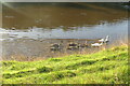
Swan family on the River Tweed
by Martin Dawes for square NT8845 Heading upstream, the river discoloured due to heavy rain
Tags:
type:Close LookX
top:Country EstatesX
top:LowlandsX
Milne Graden EstateX
Mute Swans and CygnetsX
top:PathsX
top:Rivers, Streams, DrainageX
Scottish- English BorderX
river:TweedX
top:Wild Animals, Plants and MushroomsX
|
|
Tweedside walk, footbridge over Bannock Burn
by Martin Dawes geograph for square NT8845 A walk before breakfast alongside the Tweed
Tags:
BurnX
top:Country EstatesX
type:GeographX
top:LowlandsX
Milne Graden EstateX
top:PathsX
top:Rivers, Streams, DrainageX
Scottish- English BorderX
river:TweedX
Wooden FootbridgeX
top:Woodland, ForestX
|
|
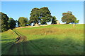
Track up from River Tweed toward Sunnyside
by Martin Dawes geograph for square NT8845 The track goes from the riverbank through the wood and joins the estate road... (more)
|
|
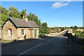
Ladykirk and Norham bridge with late c19 tollhouse
by Martin Dawes geograph for square NT8847 |
|
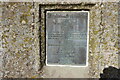
Plaque on Ladykirk and Norham Bridge built 1885-7
by Martin Dawes for square NT8947 Crossing the River Tweed this is placed in the central cutwater which forms a... (more)
|
|
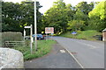
Over Norham Bridge entering Scotland on B6470
by Martin Dawes geograph for square NT8847 Footpath on the left follows River Tweed to Milne Graden
Tags:
top:Boundary, BarrierX
type:GeographX
top:LowlandsX
Norham BridgeX
top:PathsX
top:Roads, Road TransportX
Scottish- English BorderX
top:Village, Rural SettlementX
|
|
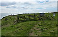
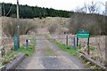
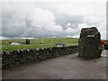
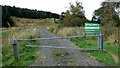
Welcome to Scotland
by Sandy Gerrard geograph for square NY5184 Forest gate across the track leading into Scotland.
Tags:
top:Boundary, BarrierX
ForestryX
GateX
subject:GateX
type:GeographX
top:Roads, Road TransportX
Scottish- English BorderX
top:UplandsX
top:Woodland, ForestX
|
|
Kershope Burn
by Jim Barton geograph for square NY5083 Looking upstream from the road to Kershope Bridge.
|