Public Tags
Tag: St·Ives
Showing latest 50 of 193 images tagged with St Ives tag.
|
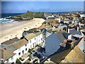
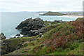
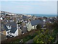
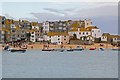
St Ives rooftops
by Marika Reinholds for square SW5141 View of St Ives rooftops, Porthmeor beach and The Island, taken from the cafe in... (more)
Tags:
top:Air, Sky, WeatherX
Art GalleryX
BeachX
subject:BeachX
top:City, Town CentreX
top:CoastalX
type:Cross GridX
top:Estuary, MarineX
place:Porthmeor BeachX
top:Public Buildings and SpacesX
RooftopsX
top:Sport, LeisureX
St Ives
Tate St IvesX
The IslandX
The Island St IvesX
|
|
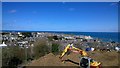
Construction above St Ives
by Steven Haslington geograph for square SW5140 Construction work high above St Ives in Cornwall, England.
|
|
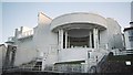
St Ives: Tate St Ives
by Jonathan Hutchins geograph for square SW5140 Art gallery in St Ives, displaying British and international modern and... (more)
|
|
Towards The Island
by Graham Horn for square SW5140 We descended from Burthallan Cliff towards the fleshpots of St Ives and... (more)
|
|
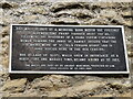
St Ives Priory wall plaque
by M J Richardson for square TL3171 The medieval walls are part of ancient monument at St Ives, where a stone coffin... (more)
Tags:
top:Boundary, BarrierX
place:CambridgeshireX
type:Close LookX
top:Historic Sites and ArtefactsX
top:LowlandsX
MedievalX
place:St Ives
St IvoX
top:Village, Rural SettlementX
subject:WallX
|
|
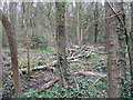
Cut wood in The Thicket
by M J Richardson geograph for square TL2971 The Thicket, a narrow and steep bank of Ash and Field Maple woodland, through... (more)
Tags:
Ash TreesX
place:CambridgeshireX
Field MapleX
type:GeographX
top:LowlandsX
top:PathsX
near:St Ives
top:Wild Animals, Plants and MushroomsX
subject:WoodlandX
top:Woodland, ForestX
|
|
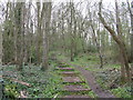
Path into The Thicket
by M J Richardson geograph for square TL2971 The Thicket is a narrow and steep bank of Ash and Field Maple woodland, through... (more)
Tags:
Ash TreesX
place:CambridgeshireX
Field MapleX
type:GeographX
top:LowlandsX
top:PathsX
near:St Ives
top:Wild Animals, Plants and MushroomsX
subject:WoodlandX
top:Woodland, ForestX
|
|
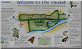
Welcome to the Thicket
by M J Richardson for square TL2971 Information about The Thicket, a narrow and steep bank of Ash and Field Maple... (more)
Tags:
place:CambridgeshireX
type:Close LookX
Information PanelX
top:LowlandsX
subject:NoticeX
top:PathsX
near:St Ives
top:Wild Animals, Plants and MushroomsX
top:Woodland, ForestX
|
|
View towards Carrick Du and The Island
by Graham Horn geograph for square SW5140 Looking east along the coast west of St Ives. The first prominent rock is... (more)
|
|
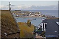
Over the rooftops
by Ian Capper geograph for square SW5140 Looking across St Ives Harbour from Tregenna Terrace. On the left is part of... (more)
Tags:
top:City, Town CentreX
top:Docks, HarboursX
HarbourX
top:Religious SitesX
place:St Ives
St Ives RC ChurchX
|
|
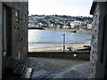
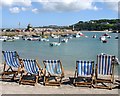
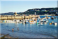
St Ives Harbour
by Marika Reinholds geograph for square SW5140 View of St Ives harbour and town from Victoria Place
Tags:
top:City, Town CentreX
top:CoastalX
top:Estuary, MarineX
type:GeographX
HarbourX
subject:HarbourX
Harbour at High TideX
Harbour ViewX
place:St Ives
St Ives
|
|
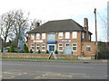
Seven Wives at St Ives
by M J Richardson geograph for square TL3172 'As I was going to St Ives I met a man with seven wives.....'. An... (more)
Tags:
top:Business, Retail, ServicesX
place:CambridgeshireX
type:GeographX
top:LowlandsX
PubX
subject:Public HouseX
top:Roads, Road TransportX
place:St Ives
top:Suburb, Urban FringeX
|
|
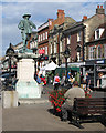
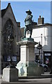
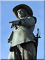
St Ives: The Lord Protector
by John Sutton geograph for square TL3171 The statue of Oliver Cromwell in St Ives market place. "Here he stands in... (more)
Tags:
season:AutumnX
top:Business, Retail, ServicesX
top:City, Town CentreX
type:GeographX
top:Historic Sites and ArtefactsX
person:Oliver CromwellX
place:St Ives
|
|
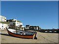
Approaching Smeaton's Pier
by Steven Haslington geograph for square SW5240 Approaching Smeaton's Pier at the headland of northeast St Ives, in... (more)
|
|
Sloop Inn
by Steven Haslington geograph for square SW5140 The Sloop Inn, a 16th-century public house in St Ives, Cornwall, England.
|
|
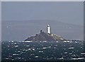
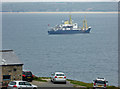
Godrevy lighthouse from St. Ives
by Steve Fareham for square SW5743 From Trinity House website:
Godrevy Island is situated 3½ miles across St.Ives... (more)
Tags:
top:CoastalX
top:CommunicationsX
county:CornwallX
top:Estuary, MarineX
Godrevy IslandX
LighthouseX
place:St Ives
Trinity HouseX
|
|
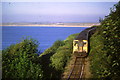
St. Ives branch line
by Malc McDonald geograph for square SW5239 A diesel multiple unit train on the branch line to St. Ives.
During the week... (more)
Tags:
Branch LineX
top:CoastalX
county:CornwallX
Diesel Multiple UnitX
Diesel TrainX
Evening SunX
Evening SunlightX
Evening SunshineX
Railway TrainX
top:RailwaysX
place:St Ives
|
|
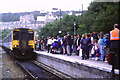
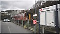
St. Ives Station
by Malc McDonald geograph for square SW5140 A diesel multiple unit train arriving at the branch line terminus at St. Ives.... (more)
|
|
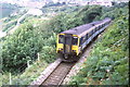
St. Ives branch line at Carbis Bay
by Malc McDonald geograph for square SW5238 A diesel multiple unit train on the branch line to St. Ives.
During the week... (more)
Tags:
Branch LineX
place:Carbis BayX
county:CornwallX
Diesel Multiple UnitX
Diesel TrainX
Railway TrainX
top:RailwaysX
near:St Ives
|
|
St Audrey Lane, St Ives
by M J Richardson geograph for square TL3172 Looking west along the A1123.
St Ives was a busy market town. The best market... (more)
Tags:
A1123X
place:CambridgeshireX
type:GeographX
top:LowlandsX
Pedestrian CrossingX
subject:RoadX
top:Roads, Road TransportX
RoadsideX
place:St Ives
top:Suburb, Urban FringeX
|
|
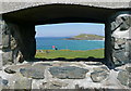
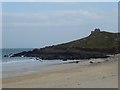
The Island, St Ives from St Nicholas Chapel
by Chris Allen for square SW5241 The Island is actually a headland and not a true island. It is home to a... (more)
|
|
St Nicholas's Chapel from Beach Road
by Rob Farrow for square SW5141 Taken from Beach Road in St Ives, near to the Tate St Ives, St Nicholas's... (more)
Tags:
subject:ChapelX
top:CoastalX
CornwallX
type:Cross GridX
top:Historic Sites and ArtefactsX
place:St Ives
top:Suburb, Urban FringeX
|
|
View over St Ives
by Rob Farrow geograph for square SW5140 Taken from near to the car park on Park Avenue, looking over St Ives. I have... (more)
|
|
St Leonard's Chapel, St Ives
by Chris Allen geograph for square SW5240 On the harbour wall and the traditional chapel for the fishermen of St Ives.
Tags:
ChapelX
top:Docks, HarboursX
Fishermens ChapelX
HarbourX
Harbour WallX
top:Religious SitesX
place:St Ives
|
|
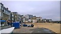
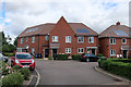
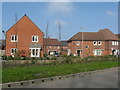
Clark Drive, St Ives
by Hugh Venables geograph for square TL2972 New housing on the edge of St Ives.
|
|
Garner Drive, St Ives
by Hugh Venables geograph for square TL2972 New housing on the edge of St Ives.
|
|
St Ives harbour
by Marika Reinholds for square SW5240 St Ives harbour with Smeaton's Pier behind, which was built in 1770. It is... (more)
Tags:
top:CoastalX
type:Cross GridX
top:Docks, HarboursX
top:Estuary, MarineX
HarbourX
subject:HarbourX
HarboursideX
LighthouseX
LighthousesX
PierX
Smeatons PierX
place:St Ives
top:Village, Rural SettlementX
|
|
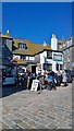
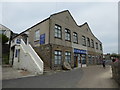
St Ives Museum
by Chris Allen geograph for square SW5240 A local history museum near the town centre and harbour in St Ives.
Tags:
top:City, Town CentreX
type:GeographX
top:Historic Sites and ArtefactsX
subject:MuseumX
place:St Ives
|
|
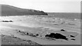
Porthmeor Sands and Clodgy Point, St Ives 1960
by Ben Brooksbank geograph for square SW5141 View west from near St Ives Head.
|
|
St Ives railway station
by Jonathan Hutchins geograph for square SW5140 Class 153 unit no.153368 at St Ives.
|
|
Merryland, St Ives
by Oxfordian Kissuth geograph for square TL3171 Merryland (street) in St Ives, Cambridgeshire.
Tags:
CambridgeshireX
top:City, Town CentreX
Oxfordian.kissuthX
St Ives
subject:StreetX
StreetX
Village StreetsX
|
|
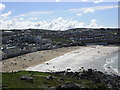
Porthmeor Beach, St Ives
by Chris Allen for square SW5140 The main surfing beach. Tate St Ives also overlooks this beach.
|
|
St Ives Harbour
by Ian Capper for square SW5240 A tangle of buildings on The Wharf (below) and Back Road East (above),... (more)
|
|
St Ives harbour and Smeaton's Pier - 1972
by Mrs. G. Reinholds for square SW5240 The image of St Ives harbour was taken by a family member during the school... (more)
Tags:
top:CoastalX
type:Cross GridX
top:Estuary, MarineX
subject:HarbourX
HarbourX
Smeatons PierX
place:St Ives
top:Suburb, Urban FringeX
|
|
St Ives harbour
by Marika Reinholds geograph for square SW5240 Christmas Eve in a gloriously sunny St Ives. Air and sky were so clear and... (more)
Tags:
Boat MooredX
top:CoastalX
top:Estuary, MarineX
type:GeographX
HarbourX
subject:HarbourX
Harbour at Low TideX
Harbour SceneX
place:St Ives
top:Village, Rural SettlementX
|
|
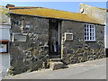
Barratts sales office, St Ives
by Hugh Venables geograph for square TL3072 The Spires is a development on the edge of St Ives, the area was previously a golf course.
Tags:
top:Business, Retail, ServicesX
top:Construction, DevelopmentX
type:GeographX
Housing Sales OfficeX
top:Housing, DwellingsX
Recently Built HousesX
place:St Ives
|
|
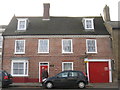
Fellmonger House at St Ives
by M J Richardson geograph for square TL3171 A Grade II listed house at 37 The Broadway, St Ives. It has been a private house... (more)
Tags:
place:CambridgeshireX
FellmongerX
type:GeographX
Grade II ListedX
top:Historic Sites and ArtefactsX
subject:HouseX
top:Housing, DwellingsX
top:LowlandsX
place:St Ives
top:Village, Rural SettlementX
|
|
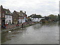
The River Great Ouse at St Ives
by M J Richardson geograph for square TL3171 Looking downstream from the 15thC St Ives Bridge. The river level is quite high... (more)
Tags:
place:CambridgeshireX
type:GeographX
river:Great OuseX
top:Housing, DwellingsX
top:LowlandsX
subject:RiverX
top:Rivers, Streams, DrainageX
place:St Ives
top:Village, Rural SettlementX
|
|
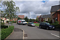
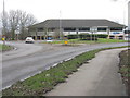
Harrison Way, St Ives
by M J Richardson geograph for square TL3271 A busy bypass road for St Ives. A small business park is accessed from the roundabout.
Tags:
A1096X
top:Business, Retail, ServicesX
place:CambridgeshireX
type:GeographX
top:LowlandsX
OfficesX
subject:RoadX
top:Roads, Road TransportX
RoundaboutX
place:St Ives
|
|
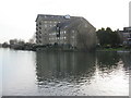
Enderby's Mill, St Ives
by M J Richardson geograph for square TL3171 Seen looking south from The Quay at St Ives' 'Riverport' area.... (more)
Tags:
subject:Apartment BlockX
place:CambridgeshireX
Converted MillX
type:GeographX
top:Historic Sites and ArtefactsX
top:Housing, DwellingsX
top:LowlandsX
Old MillX
River Great OuseX
top:Rivers, Streams, DrainageX
St Ives
Then and NowX
|
|
Garner Drive, St Ives
by M J Richardson geograph for square TL2972 New houses off the Houghton Road [A1123] on the western outskirts of St Ives.
Tags:
place:CambridgeshireX
type:GeographX
subject:HousesX
Housing EstateX
top:Housing, DwellingsX
top:LowlandsX
near:St Ives
top:Village, Rural SettlementX
|
|
Oliver Cromwell in St Ives
by M J Richardson geograph for square TL3171 Oliver Cromwell [1599-1658], and a Townsman of St Ives [1631-1636]. A statue on... (more)
Tags:
place:CambridgeshireX
top:City, Town CentreX
type:GeographX
top:LowlandsX
person:Oliver CromwellX
top:People, EventsX
near:St Ives
subject:StatueX
|
|
St Ives: the statue of Oliver Cromwell
by John Sutton for square TL3171 Brilliant November sunlight and a flawless sky made a close study of this... (more)
Tags:
season:AutumnX
place:CambridgeshireX
top:City, Town CentreX
type:Close LookX
top:Historic Sites and ArtefactsX
person:Oliver CromwellX
place:St Ives
StatueX
|
|
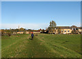
St Ives: path across Wilhorn Meadow
by John Sutton geograph for square TL3170 The footpath follows the floodbank. In the background are the causeway arches... (more)
Tags:
top:Air, Sky, WeatherX
season:AutumnX
place:CambridgeshireX
top:Flat LandscapesX
type:GeographX
river:Great OuseX
top:PathsX
top:Rivers, Streams, DrainageX
place:St Ives
top:Suburb, Urban FringeX
|
|
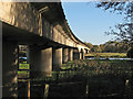
St Ives: Harrison Way Viaduct
by John Sutton geograph for square TL3170 This concrete viaduct carries the A1096, which links St Ives to the A14, across... (more)
Tags:
season:AutumnX
place:CambridgeshireX
top:Flat LandscapesX
type:GeographX
river:Great OuseX
top:Rivers, Streams, DrainageX
top:Roads, Road TransportX
place:St Ives
subject:ViaductX
|
|
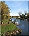
At St Ives Marina
by John Sutton geograph for square TL3170 A view from the footbridge, with the Harrison Way viaduct which carries the... (more)
Tags:
season:AutumnX
place:CambridgeshireX
top:Flat LandscapesX
type:GeographX
river:Great OuseX
top:Rivers, Streams, DrainageX
top:Roads, Road TransportX
top:Sport, LeisureX
place:St Ives
|
|
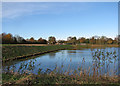
St Ives: a new lagoon
by John Sutton geograph for square TL3170 A new lake south of St Ives Marina. Bill Boaden was here in May 2014: TL3170 : Excavations on the edge of St Ives.
Tags:
season:AutumnX
place:CambridgeshireX
top:Construction, DevelopmentX
top:Flat LandscapesX
type:GeographX
river:Great OuseX
top:Lakes, Wetland, BogX
place:St Ives
|
|
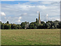
Hemingford Meadow and All Saints' spire
by John Sutton geograph for square TL3071 A view from the Hemingford to St Ives path. St Ives parish church is on the... (more)
Tags:
top:Air, Sky, WeatherX
top:Flat LandscapesX
type:GeographX
top:GrasslandX
river:Great OuseX
top:Historic Sites and ArtefactsX
top:Religious SitesX
place:St Ives
Water MeadowsX
|
|
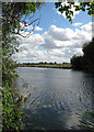
The Great Ouse and a glimpse of St Ives
by John Sutton geograph for square TL3071 The Ouse Valley Way path from Houghton to St Ives is largely away from the river... (more)
Tags:
season:AutumnX
top:Farm, Fishery, Market GardeningX
top:Flat LandscapesX
type:GeographX
river:Great OuseX
top:Rivers, Streams, DrainageX
place:St Ives
|
|
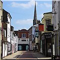
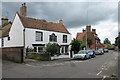
St Ives: Church Street
by John Sutton geograph for square TL3071 The house with the pretty Venetian window is The Chestnuts, which is Grade II... (more)
Tags:
top:City, Town CentreX
type:GeographX
top:Historic Sites and ArtefactsX
top:Housing, DwellingsX
place:St Ives
season:SummerX
|