Public Tags
Tag: Vale·of·Belvoir
Other tags: place:Vale of Belvoir
Showing latest 50 of 75 images tagged with Vale of Belvoir tag.
|
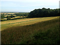
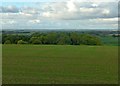
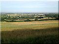
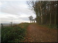
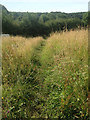
Looking down the Vale of Belvoir from Stathern Wood
by Kate Jewell for square SK7731 Looking in a northerly direction from SK7730 : Footpath marker post in Stathern Wood along the woodland at the edge... (more)
Tags:
AgricultureX
type:Cross GridX
top:Farm, Fishery, Market GardeningX
subject:FarmlandX
top:Flat LandscapesX
Vale of Belvoir
WoodlandX
|
|
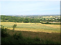
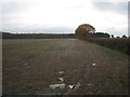
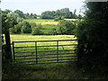
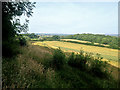
Farmland on the edge of the Vale of Belvoir
by Kate Jewell for square SK7731 Looking in a north-westerly direction from SK7730 : Footpath marker post in Stathern Wood
The Vale of Belvoir is a... (more)
Tags:
type:Cross GridX
top:Farm, Fishery, Market GardeningX
FarmingX
subject:FarmlandX
top:Flat LandscapesX
Vale of Belvoir
|
|
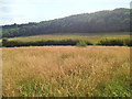
Stathern Wood on the edge of the Vale of Belvoir
by Kate Jewell geograph for square SK7730 Stathern Wood is the most southerly point of a swathe of managed mixed woodland... (more)
Tags:
top:Farm, Fishery, Market GardeningX
subject:FieldX
type:GeographX
top:GrasslandX
MeadowX
Uncut GrasslandX
Vale of Belvoir
WoodlandX
top:Woodland, ForestX
|
|
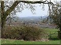
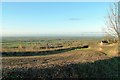
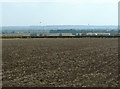
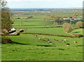
Vale of Belvoir
by Richard Croft geograph for square SK7235 Rural view across the Vale of Belvoir from the escarpment between Langar and Barnstone
|
|
View into the Vale of Belvoir
by Alan Murray-Rust geograph for square SK8234 From the road between Belvoir Castle and Woolsthorpe-by-Belvoir.
|
|
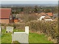
View from Kinoulton Old Churchyard
by Alan Murray-Rust geograph for square SK6630 Looking across the Vale of Belvoir with Belvoir Castle on the horizon.
Tags:
top:LowlandsX
place:Vale of BelvoirX
|
|
View towards Plungar Wood
by Jonathan Thacker geograph for square SK7933 The eastern scarp of the Vale of Belvoir is for much of its length covered in... (more)
|
|
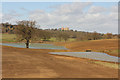
Belvoir parkland
by Richard Croft geograph for square SK8331 Recently landscaped parkland and ponds, with Belvoir Castle in the distance,... (more)
|
|
View across Stathern into the Vale of Belvoir
by Alan Murray-Rust for square SK7731 From Toft Hill cemetery, Stathern.
|
|
Grazing land by Toft's Lane
by Kate Jewell geograph for square SK7730 The Rundle Beck issues just off to the left in the photograph and flows along... (more)
|
|
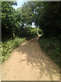
Out of the wood
by Kate Jewell geograph for square SK7730 Coming out into the sunshine through overhanging oak branches. This small young... (more)
Tags:
top:Farm, Fishery, Market GardeningX
type:GeographX
Mixed WoodlandX
Vale of Belvoir
WoodlandX
subject:WoodlandX
top:Woodland, ForestX
|
|
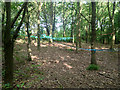
Small woodland, Vale of Belvoir
by Kate Jewell geograph for square SK7730 Definite evidence of some sort of "adventure" activity in this little... (more)
Tags:
ActivitiesX
type:GeographX
Small WoodX
Vale of Belvoir
subject:WoodlandX
top:Woodland, ForestX
|
|
Vale of Belvoir farmland
by Kate Jewell for square SK7731 Looking northwest from SK7730 : Footpath marker post in Stathern Wood
You can just see the reflections of the... (more)
Tags:
top:Business, Retail, ServicesX
type:Cross GridX
top:Farm, Fishery, Market GardeningX
subject:FarmlandX
top:Flat LandscapesX
place:Vale of BelvoirX
WholesalerX
|
|
Late afternoon sunshine over the Vale of Belvoir
by Alan Murray-Rust geograph for square SK7730 The village of Stathern lies at the foot of the hill.
|
|
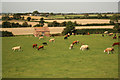
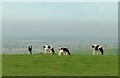
Cows on the edge
by Alan Murray-Rust geograph for square SK7628 The Leicestershire Wolds end in a steep scarp overlooking the Vale of Belvoir.... (more)
Tags:
Cattle GrazingX
EscarpmentX
top:Farm, Fishery, Market GardeningX
type:GeographX
top:LowlandsX
place:Vale of BelvoirX
|
|
Dying oak tree
by Alan Murray-Rust geograph for square SK6823 Although the lower branches are still live, the crown of the tree has died. Even... (more)
|
|
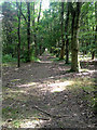
Jubilee Way in Stathern Wood
by Jonathan Thacker geograph for square SK7831 Much of the woodland to the left of the path has been cleared giving open views... (more)
|
|
Vale of Belvoir
by Alan Murray-Rust geograph for square SK6939 Looking south east from Toot Hill near Bingham. The near field is part of Top... (more)
Tags:
Arable LandX
top:Farm, Fishery, Market GardeningX
bucket:LandscapeX
top:LowlandsX
PloughlandX
place:Vale of BelvoirX
ViewX
|
|
Evening view across the Vale of Belvoir
by Alan Murray-Rust geograph for square SK7729 From the road between Eastwell and Stathern.
|
|
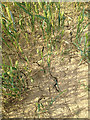
Drought evidence in a field near Stathern
by Kate Jewell geograph for square SK7730 Even though there have been a few days with very heavy downpours in June and... (more)
Tags:
AgricultureX
Clay SoilX
DroughtX
top:Farm, Fishery, Market GardeningX
type:GeographX
subject:SoilX
Vale of Belvoir
|
|
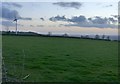
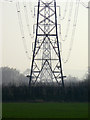
Straight down the line
by Alan Murray-Rust geograph for square SK6930 Supergrid transmission line (probably 275Kv) passing through the Vale of Belvoir.
Tags:
Electricity Transmission LinesX
top:Energy InfrastructureX
top:LowlandsX
SilhouetteX
place:Vale of BelvoirX
|
|
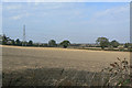
Vale of Belvoir landscape
by Alan Murray-Rust geograph for square SK6834 Near Home Farm, Colston Bassett. The metal fence in the foreground is an unusual... (more)
Tags:
Arable LandX
top:Boundary, BarrierX
top:Farm, Fishery, Market GardeningX
fence:Iron Post and RailX
bucket:LandscapeX
top:LowlandsX
place:Vale of BelvoirX
|
|
Vale of Belvoir landscape
by Alan Murray-Rust geograph for square SK6834 Near Home Farm, Colston Bassett.
Tags:
Arable LandX
top:Farm, Fishery, Market GardeningX
bucket:LandscapeX
top:LowlandsX
place:Vale of BelvoirX
|
|
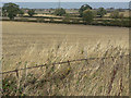
Footpath to Tithby
by Alan Murray-Rust geograph for square SK6937 Looking across the fertile countryside of the Vale of Belvoir.
Tags:
Arable LandX
top:Farm, Fishery, Market GardeningX
top:GrasslandX
bucket:LandscapeX
top:LowlandsX
top:PathsX
PloughlandX
Public FootpathX
place:Vale of BelvoirX
|
|
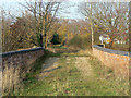
Toft's Lane, Stathern (1)
by Kate Jewell geograph for square SK7730 Looking towards Stathern
This substantial unmade "green" road leads... (more)
Tags:
Farm TrackX
type:GeographX
top:Roads, Road TransportX
Tofts LaneX
subject:TrackX
Vale of Belvoir
|
|
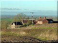
Vale View and Mill Hill, near Stathern
by Alan Murray-Rust geograph for square SK7730 Vale View is the lower house, and the name is well justified.
|
|
View into the Vale
by Alan Murray-Rust geograph for square SK6923 Looking down the scarp of the Leicestershire Wolds at Green Hill.
|
|
Small mixed woodland near Stathern
by Kate Jewell for square SK7731 This fairly new piece of woodland is very regular in shape and the trees are all... (more)
Tags:
type:Cross GridX
Forest TrackX
Mixed WoodlandX
Small WoodX
Vale of Belvoir
subject:WoodlandX
top:Woodland, ForestX
|
|
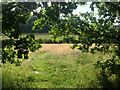
Uncut grassland near Stathern Wood
by Kate Jewell geograph for square SK7730 This narrow meadow, in the foreground of SK7730 : Stathern Wood on the edge of the Vale of Belvoir, has been left uncultivated... (more)
Tags:
top:Farm, Fishery, Market GardeningX
subject:FieldX
type:GeographX
top:GrasslandX
MeadowX
Uncut GrasslandX
Vale of Belvoir
|
|
View from Stathern Wood
by Kate Jewell geograph for square SK7730 Looking in a westerly direction from SK7730 : Footpath marker post in Stathern Wood
The footpath across this field... (more)
Tags:
AgricultureX
top:Farm, Fishery, Market GardeningX
subject:FarmlandX
type:GeographX
top:PathsX
Public FootpathX
Vale of Belvoir
|
|
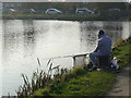
Fisherman at Hickling
by Alan Murray-Rust geograph for square SK6929 The canal basin is clearer of weeds than the adjoining reach of the canal, and... (more)
Tags:
Canal BasinX
Canal DisusedX
top:CanalsX
FishermanX
name:Grantham CanalX
top:LowlandsX
top:Sport, LeisureX
place:Vale of BelvoirX
|
|
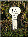
13 1/4 miles from the Trent
by Alan Murray-Rust for square SK6929 This is an original Grantham Canal milepost and is Listed Grade II. It would... (more)
Tags:
Canal DisusedX
Canal MilepostX
Canal MilestoneX
top:CanalsX
milestoneid:GRA 13X
Grade II ListedX
name:Grantham CanalX
top:LowlandsX
place:Vale of BelvoirX
|
|
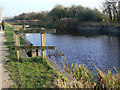
Overflow sluice at Hickling
by Alan Murray-Rust geograph for square SK6929 Used to regulate the level of water in the Grantham Canal. It discharges into a... (more)
Tags:
Canal DisusedX
top:CanalsX
name:Grantham CanalX
top:LowlandsX
OverflowX
place:Vale of BelvoirX
|
|
Swans on the Grantham Canal
by Alan Murray-Rust geograph for square SK6929 A large family, with seven well grown cygnets (not all in the picture) still in... (more)
Tags:
Canal DisusedX
Canal TowpathX
top:CanalsX
name:Grantham CanalX
top:LowlandsX
top:PathsX
place:Vale of BelvoirX
|
|
13 1/2 miles from the Trent
by Alan Murray-Rust for square SK6929 This is clearly intended as a temporary replacement, being made out of plywood,... (more)
Tags:
Canal DisusedX
Canal MilepostX
Canal MilestoneX
top:CanalsX
bucket:CloseupX
milestoneid:GRA 13X
name:Grantham CanalX
top:LowlandsX
place:Vale of BelvoirX
|
|
Memorial seat on the towpath
by Alan Murray-Rust geograph for square SK6929 Attesting to the popularity of the Grantham Canal for walking.
Tags:
Bench SeatX
Canal DisusedX
Canal TowpathX
top:CanalsX
name:Grantham CanalX
top:LowlandsX
Memorial SeatX
top:PathsX
place:Vale of BelvoirX
|
|
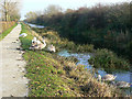
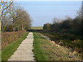
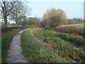
Canal towpath near Hickling
by Alan Murray-Rust geograph for square SK6929 The Grantham Canal towpath has been opened up as an accessible path over most of... (more)
Tags:
Canal DisusedX
Canal TowpathX
top:CanalsX
name:Grantham CanalX
top:LowlandsX
top:PathsX
place:Vale of BelvoirX
|
|
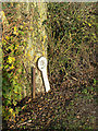
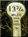
13 3/4 miles from the Trent
by Alan Murray-Rust for square SK7029 This is one of the original mileposts and is listed grade II. Note the dragonfly... (more)
Tags:
Canal MilepostX
top:CanalsX
bucket:CloseupX
DarterX
DragonflyX
Grade II ListedX
name:Grantham CanalX
top:LowlandsX
place:Vale of BelvoirX
top:Wild Animals, Plants and MushroomsX
|
|
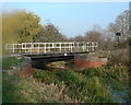
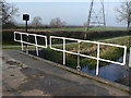
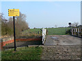
Swing bridge 31 near Hickling
by Alan Murray-Rust geograph for square SK7029 A modern reconstruction of an earlier bridge. In working order, but not to be... (more)
Tags:
Canal BridgeX
Canal DisusedX
top:CanalsX
Farm TrackX
name:Grantham CanalX
top:LowlandsX
ReconstructionX
top:Roads, Road TransportX
Swing BridgeX
place:Vale of BelvoirX
|
|
Swing bridge 31 near Hickling
by Alan Murray-Rust geograph for square SK7029 The side barriers can be hinged down to allow an extra-wide load to be taken across.
Tags:
Canal BridgeX
top:CanalsX
Farm TrackX
name:Grantham CanalX
top:LowlandsX
ReconstructionX
Swing BridgeX
place:Vale of BelvoirX
|
|
Swing bridge 31 near Hickling
by Alan Murray-Rust geograph for square SK7029 A modern reconstruction of an earlier bridge. In working order, but not to be... (more)
Tags:
Canal BridgeX
top:CanalsX
Farm TrackX
name:Grantham CanalX
top:LowlandsX
ReconstructionX
top:Roads, Road TransportX
Swing BridgeX
place:Vale of BelvoirX
|
|
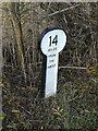
Grantham Canal near Hickling
by Alan Murray-Rust geograph for square SK7029 The 14 mile milepost Link can just be made... (more)
Tags:
Canal DisusedX
Canal TowpathX
top:CanalsX
milestoneid:GRA-14X
name:Grantham CanalX
top:LowlandsX
top:PathsX
place:Vale of BelvoirX
|
|
14 miles from the Trent
by Alan Murray-Rust for square SK7029 The Grantham Canal has mileposts every quarter of a mile, some original, many... (more)
Tags:
Canal DisusedX
Canal MilepostX
Canal MilestoneX
top:CanalsX
bucket:CloseupX
milestoneid:GRA 14X
name:Grantham CanalX
top:LowlandsX
place:Vale of BelvoirX
|
|
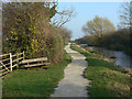
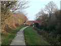
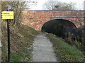
Grantham Canal
by Alan Murray-Rust geograph for square SK7029 Looking towards Clark's Bridge. At this point there is some water in the... (more)
Tags:
Arch BridgeX
Canal BridgeX
Canal DisusedX
Canal TowpathX
top:CanalsX
Grade II ListedX
name:Grantham CanalX
top:LowlandsX
top:PathsX
place:Vale of BelvoirX
|
|
Clark's Bridge
by Alan Murray-Rust geograph for square SK7029 Viewed from the west. An original structure from the building of the canal, it... (more)
Tags:
Arch BridgeX
Canal BridgeX
Canal DisusedX
Canal TowpathX
top:CanalsX
Grade II ListedX
name:Grantham CanalX
top:LowlandsX
top:PathsX
place:Vale of BelvoirX
|
|
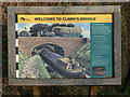
Information board at Clark's Bridge
by Alan Murray-Rust for square SK7029 Produced by British Waterways for users of the canal towpath walk.
Tags:
Canal BridgeX
Canal DisusedX
top:CanalsX
bucket:CloseCropX
bucket:CloseupX
name:Grantham CanalX
Information BoardX
top:LowlandsX
place:Vale of BelvoirX
|
|
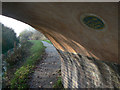
Under Clark's Bridge
by Alan Murray-Rust geograph for square SK7029 The painted name on the underside of the bridge is unusual, but appears to have... (more)
Tags:
Canal BridgeX
Canal DisusedX
Canal TowpathX
top:CanalsX
bucket:CloseupX
name:Grantham CanalX
top:LowlandsX
place:Vale of BelvoirX
|
|
Clark's Bridge
by Alan Murray-Rust geograph for square SK7029 Carrying a farm access lane over the Grantham Canal. The prospect of an 18 ton... (more)
Tags:
Arable LandX
Canal BridgeX
top:CanalsX
Farm TrackX
top:Farm, Fishery, Market GardeningX
Field HeadlandX
name:Grantham CanalX
top:LowlandsX
top:PathsX
place:Vale of BelvoirX
Weight LimitX
|
|
Clark's Bridge
by Alan Murray-Rust geograph for square SK7029 The public footpath ends at the bridge, linking with the canal towpath walk,... (more)
Tags:
Canal BridgeX
top:CanalsX
Farm TrackX
name:Grantham CanalX
top:LowlandsX
top:PathsX
place:Vale of BelvoirX
|
|
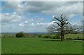
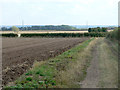
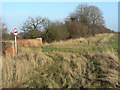
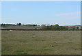
Fields near Owthorpe
by Alan Murray-Rust geograph for square SK6733 Showing vestiges of ridge and furrow cultivation.
Tags:
top:Farm, Fishery, Market GardeningX
bucket:LandscapeX
top:LowlandsX
PastureX
Ridge and FurrowX
place:Vale of BelvoirX
|