Public Tags
Showing latest 50 of 56 images tagged with area:Tythegston tag.
|
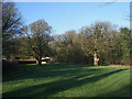
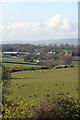
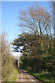
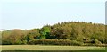
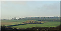
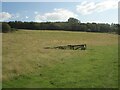
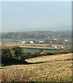
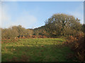
View towards the southern edge of Home Wood, Tythegston
by eswales geograph for square SS8579 The image shows part of the southern edge of the wood of broadleaf trees... (more)
Tags:
Ancient WoodlandX
type:GeographX
area:Tythegston
WoodX
subject:WoodlandX
top:Woodland, ForestX
|
|
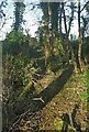
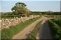
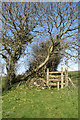
Public footpath approaching Tythegstons Long Belt
by eswales geograph for square SS8579 A public footpath which runs northwards from Tythegston to the A48 via the ruins... (more)
Tags:
type:GeographX
subject:PathX
top:PathsX
Public FootpathX
StileX
area:Tythegston
top:Woodland, ForestX
|
|
Public footpath in Tythegstons Long Belt
by eswales geograph for square SS8579 The short stretch of public footpath through the strip of trees viewed from the... (more)
|
|
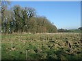
Young trees by the southern edge of Tythegstons Long Belt
by eswales geograph for square SS8579 A band of trees has recently been planted alongside the southern edge of the... (more)
|
|
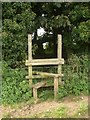
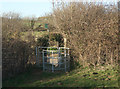
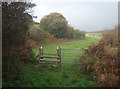
Stile at Long Belt, Tythegston
by eswales geograph for square SS8579 Stile at the point where a public footpath passes through the Long Belt of trees... (more)
|
|
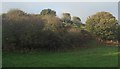
Long Belt, Tythegston
by eswales geograph for square SS8579 The Long Belt of trees at Tythegston extends for approximately six hundred... (more)
|
|
Stile on public footpath, Tythegston
by eswales geograph for square SS8579 The stile lies on a public footpath which runs northwards to the A48 from a spot... (more)
|
|
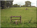
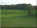
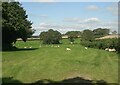
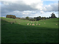
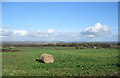
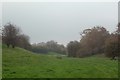
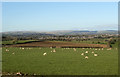
Grazing in a small valley, Tythegston
by eswales geograph for square SS8579 One of the initial views to be had when walking the public footpath which runs... (more)
Tags:
top:Farm, Fishery, Market GardeningX
type:GeographX
top:GrasslandX
subject:GrazingX
Grazing LandX
Sheep GrazingX
area:Tythegston
ValleyX
|
|
A view across a valley at Tythegston
by eswales geograph for square SS8579 This little valley is crossed by the public footpath which runs northwards from... (more)
Tags:
type:GeographX
top:GrasslandX
Grazing LandX
top:PathsX
Public FootpathX
area:Tythegston
subject:ValleyX
|
|
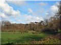
Wooded countryside, Tythegston
by eswales geograph for square SS8579 A view from the southern edge of the Long Belt of woodland at Tythegston.
Tags:
subject:CountrysideX
type:GeographX
top:GrasslandX
area:Tythegston
Wooded CountrysideX
top:Woodland, ForestX
|
|
Long Belt, Tythegston (3)
by eswales geograph for square SS8579 Trees towards the eastern end of the band of ancient woodland just north of Tythegston.
Tags:
Ancient WoodlandX
Arable FarmlandX
top:Farm, Fishery, Market GardeningX
type:GeographX
area:Tythegston
subject:WoodlandX
top:Woodland, ForestX
|
|
Kissing gate south east of Tythegston
by eswales geograph for square SS8678 Category: Kissing gate Situated beside the lane which runs southeastwards from Tythegston and at the... (more)
Tags:
top:Boundary, BarrierX
subject:GateX
Kissing GateX
Newton to Candleston Circular WalkX
top:PathsX
Public FootpathX
area:Tythegston
|
|
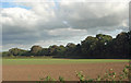
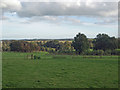
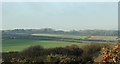
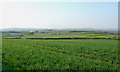
Farmland to the south of Tythegston
by eswales geograph for square SS8677 Category: Farmland View from a spot on the public footpath in the north west of the grid square... (more)
Tags:
top:Farm, Fishery, Market GardeningX
subject:FarmlandX
FarmlandX
HamletX
top:LowlandsX
area:Tythegston
top:Village, Rural SettlementX
|
|
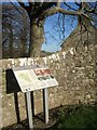
Tythegston Conservation Area information board
by eswales for square SS8578 Situated close to the entrance to the churchyard of St Tydwgs Church (which has... (more)
Tags:
type:Close LookX
Information BoardX
top:Religious SitesX
top:Sport, LeisureX
area:Tythegston
top:Village, Rural SettlementX
|
|
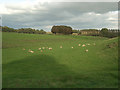
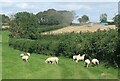
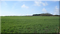
Grazing, Tythegston
by eswales geograph for square SS8578 A field for the grazing of sheep in an area of mixed agriculture.
Tags:
top:Farm, Fishery, Market GardeningX
type:GeographX
subject:GrazingX
Sheep GrazingX
area:Tythegston
|
|
Long Belt, Tythegston (2)
by eswales geograph for square SS8579 Broadleaf trees on the north side of this area of ancient woodland.
|
|
Track south east of Tythegston (2)
by eswales geograph for square SS8677 Category: Track A pleasant country track which is followed by a public footpath.
|
|
Country track to the south east of Tythegston
by eswales geograph for square SS8677 Category: Track This relatively high track is followed by a public footpath and forms a stretch... (more)
Tags:
Newton to Candleston Circular WalkX
top:PathsX
Public FootpathX
top:Roads, Road TransportX
subject:TrackX
TrackX
area:Tythegston
|
|
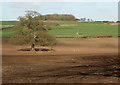
Oak in field at Tythegston
by eswales geograph for square SS8578 Category: Tree Looking roughly north east, with the area of woodland marked in the centre of... (more)
Tags:
top:Farm, Fishery, Market GardeningX
Individual TreeX
top:LowlandsX
TreeX
subject:TreeX
area:Tythegston
|
|
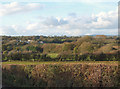
Countryside to the north west of Tythegston
by eswales geograph for square SS8579 Category: Countryside A view from a point on the grid square's lane towards what Ordnance... (more)
|
|
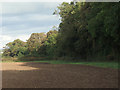
Mixed woodland south east of Tythegston
by eswales geograph for square SS8677 Category: Woodland View of mixed woodland adjacent to the stretch of track in the north east of the... (more)
|
|
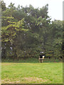
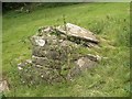
Well, Tythegston - side view
by eswales for square SS8579 The east facing side of the well.
|
|
Well, Tythegston
by eswales geograph for square SS8579 The well lies just to the north west of the hamlet and beside a public footpath.
|
|
Farmland just west of Tythegston
by eswales for square SS8578 Arable farmland to the south of the A4106 sloping downwards towards the hamlet... (more)
|
|
Farmland between Wig Fach and Tythegston
by eswales for square SS8578 Arable farmland to the south of the A4106 viewed from a public footpath in the... (more)
|
|
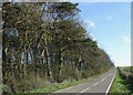
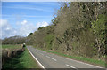
Country road to the west of Tythegston (2)
by eswales geograph for square SS8479 Category: Country road A view along the road looking in the opposite direction is provided by SS8479 : Country road to the west of Tythegston.
|
|
Country road to the west of Tythegston
by eswales geograph for square SS8479 Category: Country road Showing a part of a strip of mixed woodland running alongside the road which... (more)
|
|
Countryside by Tythegston
by eswales geograph for square SS8678 Category: Countryside As seen from the lane in the west of the grid square.
|
|
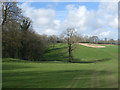
The east slope of Cwm y Befos
by eswales geograph for square SS8578 The grassy east slope of the valley by Tythegston is seen, together with one of... (more)
|
|
Mixed agriculture, Tythegston
by eswales geograph for square SS8578 As sheep graze in the foreground, a crop is being harvested in a field beyond.
Tags:
subject:AgricultureX
top:Boundary, BarrierX
top:Farm, Fishery, Market GardeningX
type:GeographX
GrazingX
HarvestingX
HedgeX
Mixed AgricultureX
Sheep GrazingX
area:Tythegston
|
|
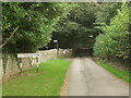
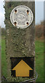
Minor road arriving at Tythegston
by eswales for square SS8578 The green sign lies at the start of a public footpath which runs northwards to... (more)
Tags:
type:Cross GridX
Minor RoadX
Public Footpath SignX
subject:RoadX
top:Roads, Road TransportX
area:Tythegston
|
|
A view along a valley at Tythegston
by eswales geograph for square SS8579 A small valley used for grazing.
Tags:
top:Farm, Fishery, Market GardeningX
type:GeographX
top:GrasslandX
Grazing LandX
Sheep GrazingX
area:Tythegston
subject:ValleyX
|
|
Tythegston from the south
by eswales for square SS8578 The hamlet viewed from the north of Merthyr Mawr Warren in slightly misty conditions.
Tags:
top:Farm, Fishery, Market GardeningX
FarmlandX
top:GrasslandX
subject:HamletX
HamletX
area:Tythegston
top:Village, Rural SettlementX
top:Woodland, ForestX
|
|
Stile above Cwm y Befos
by eswales geograph for square SS8678 Category: Stile On the public footpath which runs between the country lane south east of... (more)
|
|
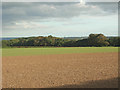
Farmland to the south east of Tythegston
by eswales geograph for square SS8677 Category: Farmland A view over fertile farmland from a public footpath.
Tags:
top:Farm, Fishery, Market GardeningX
subject:FarmlandX
FarmlandX
top:LowlandsX
area:Tythegston
|
|
Farmland to the west of Tythegston
by eswales geograph for square SS8478 Category: Farmland A view from the side of a country road. The partly-obscured group of trees in... (more)
Tags:
top:Farm, Fishery, Market GardeningX
FarmlandX
subject:FarmlandX
top:Flat LandscapesX
Newton DownX
area:Tythegston
|
|
Farmland east of Tythegston (2)
by eswales geograph for square SS8678 Category: Farmland Tags:
top:Farm, Fishery, Market GardeningX
subject:FarmlandX
FarmlandX
top:LowlandsX
area:Tythegston
|
|
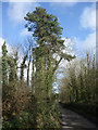
Tall conifer by lane to the north west of Tythegston
by eswales geograph for square SS8579 Category: Tree A Scots Pine towers over a very narrow lane which a sign to the north west of... (more)
|
|
Countryside to the north west of Tythegston (2)
by eswales geograph for square SS8579 Category: Countryside A view from a point on a public footpath which crosses the land seen in the... (more)
Tags:
subject:CountrysideX
top:GrasslandX
Public FootpathX
TreesX
area:Tythegston
top:Woodland, ForestX
|
|
Farmland east of Tythegston
by eswales geograph for square SS8678 Category: Farmland Looking northwards from a point on track in the south of the grid square over... (more)
Tags:
top:Farm, Fishery, Market GardeningX
subject:FarmlandX
FarmlandX
top:LowlandsX
area:Tythegston
|
|
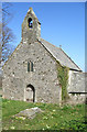
Church of St Tydwg, Tythegston
by eswales geograph for square SS8578 Category: Church South (or possibly south west) face of church as seen from just inside the... (more)
Tags:
subject:ChurchX
ChurchX
Grade 2 Listed BuildingX
Grade II ListedX
Listed BuildingX
Listed StructureX
top:Religious SitesX
area:Tythegston
|
|
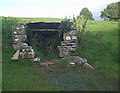
Glamorgan Heritage Coast logo, Cwm y Befos
by eswales for square SS8577 Attached to the left hand post of the stile seen in SS8577 : Stile and gate, Cwm y Befos. There do not... (more)
|
|
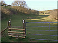
Stile on the Newton to Candleston Circular Walk, Cwm y Befos
by eswales geograph for square SS8577 Category: Stile A stile situated at the point where the public footpath which runs up Cwm y... (more)
Tags:
top:Boundary, BarrierX
Cwm Y BefosX
top:GrasslandX
Grazing LandX
Newton to Candleston Circular WalkX
top:PathsX
Public FootpathX
SignageX
StileX
subject:StileX
area:Tythegston
ValleyX
WaymarkX
WaymarkerX
|
|
Cwm y Befos in late autumn (2)
by eswales geograph for square SS8577 A view from the public footpath which runs along part of the valley.
Tags:
season:AutumnX
Cwm Y BefosX
top:GrasslandX
Newton to Candleston Circular WalkX
top:PathsX
Public FootpathX
area:Tythegston
subject:ValleyX
ValleyX
|
|
Valley side, Cwm y Befos (2)
by eswales geograph for square SS8577 A small section of the east side of the little valley viewed from a spot beside... (more)
|
|
Valley side, Cwm y Befos
by eswales geograph for square SS8577 Looking towards the west side of the valley from a spot beside the stile and... (more)
|
|
Stile and gate, Cwm y Befos
by eswales geograph for square SS8577 An autumn view of the stile and gate which lie on the boundary between the... (more)
Tags:
season:AutumnX
top:Boundary, BarrierX
Cwm Y BefosX
GateX
top:PathsX
Public FootpathX
subject:StileX
StileX
area:Tythegston
|
|
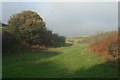
Cwm y Befos in late autumn
by eswales geograph for square SS8578 The north of the valley seen in a brief gloom on a day of greatly varying light.
Tags:
top:Air, Sky, WeatherX
season:AutumnX
Cwm Y BefosX
GloomX
GloomyX
top:GrasslandX
GrazingX
Grazing LandX
area:Tythegston
subject:ValleyX
top:Woodland, ForestX
|
|
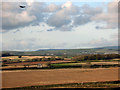
Farmland south of Laleston
by eswales geograph for square SS8678 Category: Farmland Mixed farmland viewed from a high track/public footpath on the Newton to... (more)
Tags:
top:Farm, Fishery, Market GardeningX
FarmlandX
subject:FarmlandX
top:GrasslandX
GrazingX
Grazing LandX
area:Tythegston
|
|
Spring vegetation, Cwm y Befos
by eswales geograph for square SS8577 Category: Vegetation A view from the public footpath which runs along a part of the valley.
|