Public Tags
Tag: Ben·Nevis
Showing latest 50 of 63 images tagged with Ben Nevis tag.
|
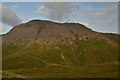
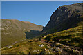
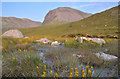
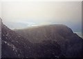
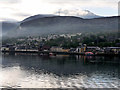
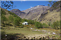
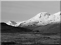
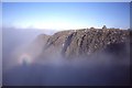
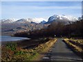
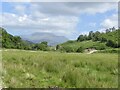
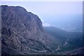
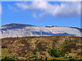
Ben Nevis, Scotland, Great Britain
by Andrew Tryon geograph for square NN1472 The northwest face of Ben Nevis in the Scottish Highlands, Britain's... (more)
Tags:
place:Ben NevisX
Ben Nevis AscentX
Ben Nevis PathX
Ben Nevis RouteX
type:GeographX
place:Great BritainX
place:LochaberX
subject:MountainX
place:ScotlandX
place:Scottish HighlandsX
top:UplandsX
|
|
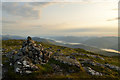
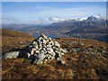
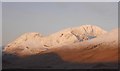
Summit Cairn on Meall an t-Suidhe, Ben Nevis, Great Britain
by Andrew Tryon geograph for square NN1372 The summit cairn of Meall an t-Suidhe (711 m, 2333 ft) with a view of Loch... (more)
Tags:
Ben Nevis
type:GeographX
Great BritainX
Loch LinnheX
Meall an T-SuidheX
subject:SummitX
Summit CairnX
top:UplandsX
|
|
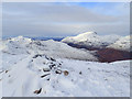
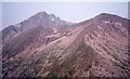
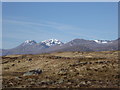
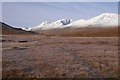
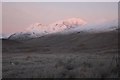
View of Ben Nevis From Binnein Mór South Top (1062m)
by Mick Garratt geograph for square NN2165 Ben Nevis NN1671
|
|
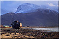
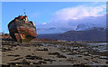
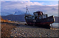
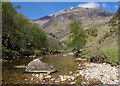
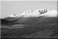
Ben Nevis from the Corpach Wreck
by Andy Stephenson for square NN1571 The classic view of Carn Dearg and Ben Nevis, taken from near the wreck of the... (more)
Tags:
landmark:Ben NevisX
place:Ben NevisX
Boat WreckX
near:CorpachX
type:Cross GridX
top:Estuary, MarineX
Fishing Boat WreckX
near:Fort WilliamX
subject:MountainX
MountainX
Mountain SceneX
Mountain ViewX
Scottish HighlandsX
Snow Capped MountainsX
top:UplandsX
View of Ben NevisX
WreckX
Wrecked BoatX
|
|
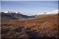
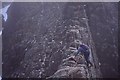
Footpath to the north of Ben Nevis, Scottish Highlands
by Andrew Tryon geograph for square NN1573 This footpath is a safe route contouring around the north side of Ben Nevis,... (more)
|
|
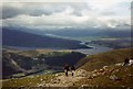
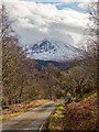
Heading for Ben Nevis
by M J Richardson geograph for square NN1571 Category: Landscape The main path to Ben Nevis from Glen Nevis, which is the near glen. Beyond that... (more)
|
|
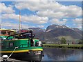
Distant Ben Nevis from Neptune's Staircase
by Marika Reinholds geograph for square NN1177 Clouds above Ben Nevis lifted just as I arrived at Neptune's Staircase on... (more)
Tags:
landmark:Ben NevisX
place:BenevieX
canal:CaledonianX
canal:Caledonian CanalX
Caledonian CanalX
top:CanalsX
type:GeographX
subject:MountainX
Neptunes Staircase Canal LocksX
top:UplandsX
View of Ben NevisX
top:Village, Rural SettlementX
|
|
Two Hulks
by Andy Stephenson geograph for square NN0976 The MV Dayspring, with Ben Nevis providing a dramatic backdrop.... (more)
Tags:
top:Air, Sky, WeatherX
landmark:Ben NevisX
place:Ben NevisX
subject:BoatX
Boat WreckX
top:CoastalX
near:CorpachX
top:Estuary, MarineX
Fishing Boat WreckX
near:Fort WilliamX
type:GeographX
Scottish HighlandsX
View of Ben NevisX
WreckX
Wrecked BoatX
|
|
Bog and Flowers on Ben Nevis, Scottish Highlands
by Andrew Tryon geograph for square NN1473 A rarely seen view of Ben Nevis from Coire Dubh, away from the tourist path, on... (more)
|
|
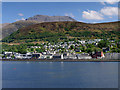
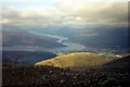
Fort William, Cow Hill and Ben Nevis
by David Dixon for square NN1671 Although Fort William is often described as a "Gateway to Ben Nevis",... (more)
Tags:
Ben Nevis
top:CoastalX
Cow HillX
type:Cross GridX
top:Estuary, MarineX
Fort WilliamX
Loch LinnheX
MountainX
camera:Panasonic DMC-G7X
Scottish HighlandsX
Sea LochX
top:UplandsX
|
|
Fort William and the 'Grey Elephant'
by Bill Kasman for square NN0973 Ben Nevis towers over Fort William. The Ben is sometimes known amongst older... (more)
Tags:
Ben Nevis
type:Cross GridX
Fort WilliamX
top:Geological InterestX
Grey ElephantX
The Grey ElephantX
top:UplandsX
|
|
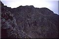
Ben Nevis
by Catherine Smith geograph for square NN1671 North-facing cliffs below the summit of Britain's highest mountain. In the... (more)
|
|
Ben Nevis and Carn Dearg
by M J Richardson geograph for square NN1671 Category: Mountain Cliff at the summit of Ben Nevis, with Carn Dearg beyond. In the far distance... (more)
|
|
Carn Mor Dearg and Ben Nevis from the east
by Jim Barton for square NN1772 A view from the ridge between Aonach Mor and Aonach Beag looking back to Carn... (more)
Tags:
top:Barren PlateauxX
Ben Nevis
CragsX
type:Cross GridX
RidgesX
top:Rocks, Scree, CliffsX
Scree SlopesX
top:UplandsX
|
|
Minor road Tomacharich
by valenta geograph for square NN1378 The view of Ben Nevis in the far distance dominates the scene
Tags:
Ben Nevis
type:GeographX
place:LochaberX
subject:MountainsideX
top:Roads, Road TransportX
top:UplandsX
View of Ben NevisX
top:Woodland, ForestX
|
|
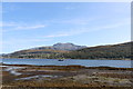
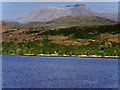
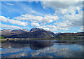
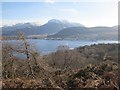
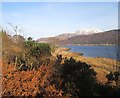
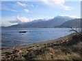
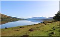
Loch Linnhe and Ben Nevis
by David Dixon for square NN1873 A view of Britain's highest mountain, Ben Nevis, from Loch Linnhe.
Tags:
Ben Nevis
type:Cross GridX
top:Estuary, MarineX
Grampian MountainsX
bucket:LandscapeX
Loch LinnheX
MountainX
camera:Panasonic DMC-G7X
Scottish HighlandsX
Sea LochX
top:UplandsX
|
|
Fort William, Cow Hill and (almost) Ben Nevis
by David Dixon for square NN1073 Looking towards Fort William from Loch Linnhe. The hill immediately behind the... (more)
Tags:
Ben Nevis
top:City, Town CentreX
type:Cross GridX
top:Estuary, MarineX
HillX
Loch LinnheX
MistX
MountainX
camera:Panasonic DMC-G7X
Sea LochX
top:UplandsX
|
|
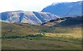
Ben Nevis and the Aonachs from Rannoch Moor
by Alan O'Dowd for square NN1971 A view of Ben Nevis, Aonach Mor and Aonach Beag showing a very limited amount of... (more)
Tags:
Aonach BeagX
Aonach MorX
Ben Nevis
type:Cross GridX
top:MoorlandX
subject:MountainX
MunrosX
Rannoch MoorX
Snow PatchesX
top:UplandsX
|
|
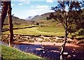
View from Staoineag bothy
by Bill Kasman geograph for square NN2967 This photograph, taken from just outside Staoineag bothy looks west to far... (more)
|
|
Ben Nevis from Corpach
by Steve Fareham for square NN1671 |
|
Ben Nevis from Corpach Locks
by Steve Fareham geograph for square NN0976 On the Caledonian Canal.
|
|
The Crofters' Wood, Camusnagaul
by Richard Webb geograph for square NN0975 A view over the tree tops towards Fort William and Ben Nevis. The woodland at... (more)
|

|
Ben Nevis summit plateau
by Richard Webb for square NN1671 In this view from Meall an t-Slamain to the south west, the complexities of safe... (more)
|
|
MV Dayspring
by Andy Stephenson geograph for square NN0976 A sad but interesting sight, the "Corpach Wreck", with Ben Nevis looming behind.
Tags:
top:Air, Sky, WeatherX
place:Ben NevisX
subject:BoatX
Boat WreckX
top:CoastalX
near:CorpachX
top:Derelict, DisusedX
top:Estuary, MarineX
Fishing Boat WreckX
near:Fort WilliamX
type:GeographX
Mountain ViewX
Scottish HighlandsX
Snow Capped MountainsX
top:UplandsX
View of Ben NevisX
WreckX
Wrecked BoatX
|
|
View down Glen Nevis
by Richard Webb for square NN2568 Along the Abhainn Rath towards the imperceptible (and very boggy) watershed with... (more)
Tags:
river:Abhainn RathX
p150 hill:Aonach BeagX
p600 hill:Ben NevisX
type:Cross GridX
top:Lakes, Wetland, BogX
top:MoorlandX
top:Rivers, Streams, DrainageX
top:Rocks, Scree, CliffsX
|
|
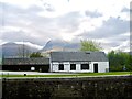
Steall Hut
by Ian Taylor geograph for square NN1768 In the upper section of Glen Nevis. Ben Nevis fills the background.
|
|
Water of Nevis
by Ian Taylor geograph for square NN1768 Looking downstream. Ben Nevis fills the background.
|
|
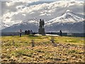
Commando Memorial, Ben Nevis and Aonach Mòr
by David Dixon geograph for square NN2082 |
|
About half way there
by M J Richardson geograph for square NN1471 Category: Landscape View from the path to Ben Nevis, looking back down the Red Burn or Allt na... (more)
|
|
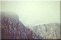
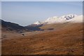
Ben Nevis from the East
by Richard Webb for square NN1671 View from frozen bogs near Meanach with the North East Buttress clearly visible... (more)
Tags:
top:Air, Sky, WeatherX
top:Barren PlateauxX
p600 hill:Ben NevisX
type:Cross GridX
top:Geological InterestX
top:Rocks, Scree, CliffsX
|
|
Loch Treig to Glen Nevis path
by Richard Webb geograph for square NN2768 View towards Ben Nevis and Aonach Beag from near Meanach/Meananach. From here... (more)
Tags:
top:Air, Sky, WeatherX
p150 hill:Aonach BeagX
p600 hill:Ben NevisX
BogX
type:GeographX
top:Lakes, Wetland, BogX
top:PathsX
p150 hill:Sgurr Choinnich MorX
|
|
Ben Nevis and Aonach Beag
by Richard Webb for square NN1971 A view from the east, down Glen Nevis.
Tags:
top:Air, Sky, WeatherX
p150 hill:Aonach BeagX
top:Barren PlateauxX
p600 hill:Ben NevisX
type:Cross GridX
top:Lakes, Wetland, BogX
top:MoorlandX
|
|
A view down Glen Nevis
by Richard Webb for square NN2768 Mamores on the left, Ben Nevis and Aonach Beag on the right. Taken on an ascent... (more)
Tags:
river:Abhainn RathX
p150 hill:Aonach BeagX
p600 hill:Ben NevisX
p150 hill:Binnein BeagX
p150 hill:Binnein MorX
BogX
type:Cross GridX
FrostX
top:Lakes, Wetland, BogX
top:MoorlandX
top:Rivers, Streams, DrainageX
p150 hill:Sgurr Choinnich MorX
|
|
Summit, Ben Nevis
by Richard Webb geograph for square NN1671 A Brocken spectre at the top of Tower Ridge with a view over the cloud and Tower... (more)
|
|
North face of The Ben
by Richard Webb geograph for square NN1671 Crags on Ben Nevis, the headwall of Coire na Ciste, seen from Tower Ridge.
|
|
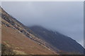
Ben Nevis in cloud
by Ian S for square NN1371 |
|
Dail an Draighinn
by Richard Webb geograph for square NN0672 Shoreline of Loch Linnhe and a view of Ben Nevis beyond Fort William's... (more)
|
|
A861, Achaphubuil
by Richard Webb geograph for square NN0875 View of Ben Nevis from across Loch Linnhe.
Tags:
p600 hill:Ben NevisX
top:Roads, Road TransportX
|
|
Summit, Meall an t-Slamain
by Richard Webb geograph for square NN0773 A good viewpoint for Fort William, Great Glen and Ben Nevis.
|
|
Beach, Camusnagaul
by Richard Webb geograph for square NN0975 A beach opposite Fort William with a fine view of Ben Nevis.
|
|
Looking NW from the path up Ben Nevis, from about 1200m
by M J Richardson geograph for square NN1571 Category: Landscape Fort William is behind the 'whale-back' hill in the centre [Meall an... (more)
|
|
Glen Scaddle
by Richard Webb geograph for square NN0068 Looking out of Glen Scaddle towards Ben Nevis.
Tags:
p600 hill:Ben NevisX
top:Farm, Fishery, Market GardeningX
type:GeographX
top:MoorlandX
top:Woodland, ForestX
|
|
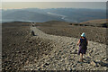
The Tourist Path on the Summit Plateau of Ben Nevis, Scottish Highlands
by Andrew Tryon geograph for square NN1671 The path approaching the summit is clearly visible in good weather and marked with cairns.
Tags:
top:Barren PlateauxX
Ben Nevis
CairnsX
type:GeographX
MountainsX
subject:PlateauX
top:Rocks, Scree, CliffsX
Rough PathX
RouteX
ScotlandX
Scree PathX
Stony GroundX
Stony PathX
top:UplandsX
Waymarked PathX
|
|
Path to Cow Hill
by Bill Kasman for square NN1072 Seen here from the viewpoint at Blarmachfoldach the path in the centre of the... (more)
Tags:
Ben Nevis
BlarmacfoldachX
Cow HillX
type:Cross GridX
Fort WilliamX
Lundavra RoadX
top:PathsX
top:UplandsX
|
|
Loch Eil
by Bill Kasman for square NM9778 Ben Nevis in the distance.
|
|
Carn Dearg, Ben Nevis 1976
by Jim Barton for square NN1672 Looking across Coire Leis to the steep cliffs of Carn Dearg with the Douglas... (more)
Tags:
Ben Nevis
CragsX
type:Cross GridX
top:Rivers, Streams, DrainageX
top:Rocks, Scree, CliffsX
top:UplandsX
|
|
Ben Nevis and Aonach Beag
by Richard Webb for square NN2070 View of a couple of big hills from the east. The huge East Face of Aonach Beag shows well.
Tags:
top:Air, Sky, WeatherX
p150 hill:Aonach BeagX
p600 hill:Ben NevisX
CragsX
type:Cross GridX
top:Rocks, Scree, CliffsX
|
|
Alpenglow, Aonach Beag
by Richard Webb for square NN1971 The remote and often unseen great East Face of Aonach Beag catches the first... (more)
Tags:
top:Air, Sky, WeatherX
p150 hill:Aonach BeagX
p600 hill:Ben NevisX
CragsX
type:Cross GridX
FrostX
top:Rocks, Scree, CliffsX
|
|
Tower Gap
by Richard Webb geograph for square NN1671 The ridge between the Great Tower and the main bulk of Ben Nevis. It is narrow... (more)
|
|
Antenna on Cow Hill
by David Dixon for square NN1173 Antenna on Cow Hill with the summit of Ben Nevis behind.
Tags:
AntennaeX
Ben Nevis
top:CommunicationsX
Cow HillX
type:Cross GridX
HillX
MountainX
camera:Panasonic DMC-G7X
Scottish HighlandsX
top:UplandsX
|