Public Tags
Tag: Brown·Field·Site
Showing images tagged with Brown Field Site tag.
|
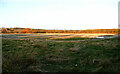
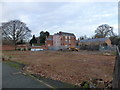
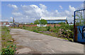
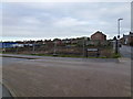
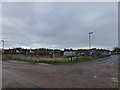
A 'brown field' site, Hipperholme
by Humphrey Bolton for square SE1225 This large area has been cleared of the industrial buildings, yards and roadways... (more)
Tags:
Brown Field Site
top:Construction, DevelopmentX
type:Cross GridX
top:LowlandsX
subject:SiteX
Site Awaiting RedevelopmentX
top:Suburb, Urban FringeX
|
|
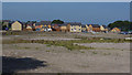
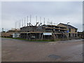
Brown-field housing development, Hapton
by Ian Taylor for square SD7932 New houses being built on the former Blythe's chemical works site.... (more)
Tags:
Brown Field Site
top:Construction, DevelopmentX
type:Cross GridX
Housing DevelopmentX
subject:Housing EstateX
top:Housing, DwellingsX
|
|
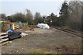
Brown field land south of railway station
by M J Roscoe geograph for square SM9901 In the past there were railway sidings here. The white sign on a pole says,... (more)
|
|
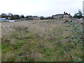
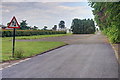
Cottingwood Common
by Mick Garratt geograph for square NZ1987 Tags:
Brown Field Site
top:Farm, Fishery, Market GardeningX
subject:FieldX
FieldX
top:Health and Social ServicesX
top:Housing, DwellingsX
top:Public Buildings and SpacesX
Race Course (Disused)X
former:RacecourseX
|
|
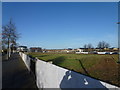
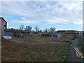
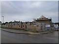
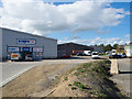
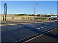
Redevelopment site by Penn Road, Wolverhampton
by Roger D Kidd geograph for square SO9197 The industrial buildings have been demolished and cleared away and this site off... (more)
Tags:
Brown Field Site
Building SiteX
top:Construction, DevelopmentX
top:Derelict, DisusedX
type:GeographX
top:Suburb, Urban FringeX
|
|
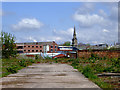
Site of Former Ironworks
by Mick Garratt geograph for square NZ0837 The main office building is still standing.
|
|
Cleared Site of the Ironworks
by Mick Garratt geograph for square NZ0836 |
|
Viaduct on Stour Valley Line, 1980
by Trevor Littlewood geograph for square SJ9100 The viaduct as seen from the tow path of the Birmingham Canal in the vicinity of... (more)
Tags:
Brown Field Site
top:Derelict, DisusedX
top:Energy InfrastructureX
GasometerX
type:GeographX
top:LowlandsX
Railway ViaductX
top:RailwaysX
top:Suburb, Urban FringeX
subject:ViaductX
|
|
Redevelopment of the former Collett's site in Wisbech
by Richard Humphrey geograph for square TF4609 This site, between Churchill Road and St Augustine's Road, was previously... (more)
Tags:
Brown Field Site
ConstructionX
top:Construction, DevelopmentX
HousingX
subject:RedevelopmentX
RedevelopmentX
|
|
Cleared industrial land near Rotton Park, Birmingham
by Roger D Kidd for square SP0487 Looking east across the island formed by the old and new main lines of the... (more)
|
|
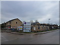
Still awaiting development - Nene Waterfront Regeneration in Wisbech
by Richard Humphrey geograph for square TF4610 This large area of land between the police station and the Boathouse on Nene... (more)
Tags:
Brown Field Site
top:Construction, DevelopmentX
DevelopmentX
Development SiteX
type:GeographX
LandX
QuaysideX
subject:WaterfrontX
|
|
Awaiting development - Nene Waterfront Regeneration in Wisbech
by Richard Humphrey geograph for square TF4610 This large area of land between the police station and the Boathouse on Nene... (more)
Tags:
Brown Field Site
top:Construction, DevelopmentX
DevelopmentX
Development SiteX
type:GeographX
LandX
QuaysideX
subject:WaterfrontX
|
|
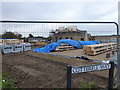
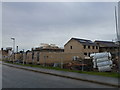
Redevelopment land by Penn Road, Wolverhampton
by Roger D Kidd geograph for square SO9197 The old Metal Castings buildings have been demolished and cleared away and this... (more)
Tags:
Brown Field Site
top:City, Town CentreX
top:Construction, DevelopmentX
top:Derelict, DisusedX
type:GeographX
|
|
Redevelopment land by Penn Road, Wolverhampton
by Roger D Kidd geograph for square SO9197 A telephoto assisted image looking towards the city from Graiseley Hill. The... (more)
Tags:
Brown Field Site
top:Construction, DevelopmentX
top:Derelict, DisusedX
type:GeographX
top:Suburb, Urban FringeX
|
|
Redevelopment of the former Collett's and Blackfriar's site in Wisbech
by Richard Humphrey geograph for square TF4609 Tags:
Brown Field Site
ConstructionX
top:Construction, DevelopmentX
HousingX
RedevelopmentX
subject:RedevelopmentX
|
|
Nene Waterfront regeneration, Wisbech - No 10
by Richard Humphrey geograph for square TF4610 At the junction of Cotterell Way and De Havilland Road
This is part of a large... (more)
|
|
Nene Waterfront regeneration, Wisbech - No 9
by Richard Humphrey geograph for square TF4610 At the junction of Cotterell Way and De Havilland Road
This is part of a large... (more)
|
|
Nene Waterfront regeneration, Wisbech - No 8
by Richard Humphrey geograph for square TF4610 This is part of a large area on the side of The River Nene which was razed to... (more)
|
|
Nene Waterfront regeneration, Wisbech - No 7
by Richard Humphrey geograph for square TF4610 On Cotterell Way
This is part of a large area on the side of The River Nene... (more)
|
|
Nene Waterfront regeneration, Wisbech - No 6
by Richard Humphrey geograph for square TF4610 On Cotterell Way.
This is part of a large area on the side of The River Nene... (more)
|
|
Nene Waterfront regeneration, Wisbech - No 5
by Richard Humphrey geograph for square TF4610 At the junction of Cotterell Way and Chase Street
This is part of a large area... (more)
|
|
Nene Waterfront regeneration, Wisbech - No 4
by Richard Humphrey geograph for square TF4610 At the junction of Chase Street and Cotterell Way.
This is part of a large area... (more)
|
|
Nene Waterfront regeneration, Wisbech - No 3
by Richard Humphrey geograph for square TF4610 This is part of a large area on the side of The River Nene which was razed to... (more)
|
|
Earth mound with trig point-like object
by Trevor Littlewood geograph for square NZ1927 The location is a brownfield site in Bishop Auckland where on a visit to... (more)
|
|
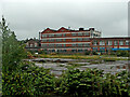
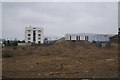
View towards the Lily Building
by Mr Ignavy geograph for square SU6352 The land has recently been cleared of secondary vegetation growth, see... (more)
Tags:
Brown Field Site
top:Derelict, DisusedX
|
|
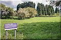
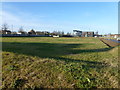
Redevelopment land
by Philip Halling geograph for square SP0077 Land beside the A38 at Longbridge awaiting redevelopment.
|
|
Cottingwood Common
by Mick Garratt geograph for square NZ1987 One of the abandoned estate roads in the hospital grounds. On the actual route... (more)
Tags:
Brown Field Site
top:Derelict, DisusedX
subject:HospitalX
top:PathsX
top:Public Buildings and SpacesX
former:RacecourseX
subject:RoadX
|