Public Tags
Tag: Building·at·Risk
Showing latest 50 of 140 images tagged with Building at Risk tag.
|
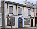
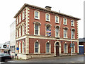
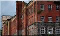
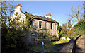
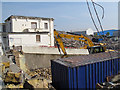
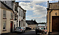
No 5 High Street, Donaghadee (2011)
by Albert Bridge for square J5979 On the register of Buildings at Risk where it is described as 5 High Street... (more)
|
|
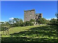
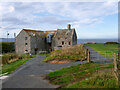
Arnside Tower
by Adrian Taylor geograph for square SD4576 Arnside Tower is a privately owned, neglected, deteriorating and partly... (more)
|
|
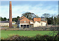
Rosefield Mills - a building at risk
by Rose and Trev Clough geograph for square NX9775 End bay of the building shown here NX9775 : Rosefield Mill .
This former tweed mill, dated... (more)
Tags:
Buildings at RiskX
listed building:Category BX
top:Derelict, DisusedX
place:DumfriesX
Former Tweed MillX
top:IndustryX
Rosefield MillsX
|
|
Nos 22-24 Ferry Street. Portaferry
by Albert Bridge geograph for square J5950 A derelict building (right in J5950 : Ferry Street, Portaferry (3)). On the official At Risk register... (more)
|
|
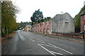
Former bank and Crown Buildings, Ballymena
by Albert Bridge geograph for square D1003 The building seen from Pats Brae. It was previously the offices of the... (more)
|
|
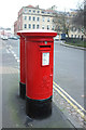
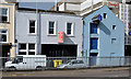
Postboxes, Portland Square, Bristol
by Derek Harper geograph for square ST5973 The nearer, George V, postbox is numbered BS2 2292. The junction is with Surrey... (more)
Tags:
Buildings at RiskX
Buildings Which Are ListedX
top:City, Town CentreX
top:CommunicationsX
top:Flat LandscapesX
type:GeographX
postbox:George VX
top:Historic Sites and ArtefactsX
top:Park and Public GardensX
PostboxesX
SquareX
TreesX
|
|
No 890 Antrim Road, Templepatrick (1)
by Albert Bridge geograph for square J2285 A three-storey vacant house in the main street. Not listed and not on the at... (more)
|
|
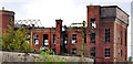
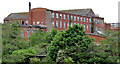
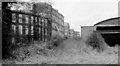
Former Barbour's Mill, Hilden (6)
by Albert Bridge for square J2865 See J2865 : Former Barbour's Mill. Hilden (5). I walked along the towpath, from Lambeg, arriving at Hilden... (more)
|
|
Former Barbour's Mill. Hilden (5)
by Albert Bridge for square J2865 Four days later this building (on the southern side of the site) was damaged by... (more)
|
|
Derelict pub, Catrine
by Humphrey Bolton geograph for square NS5225 Apparently this was the Old Mill Inn. It was built in the early 19C as two... (more)
Tags:
road:B705X
Building at Risk
top:Business, Retail, ServicesX
top:Derelict, DisusedX
Former PubX
type:GeographX
top:LowlandsX
top:Roads, Road TransportX
subject:RuinX
top:Village, Rural SettlementX
|
|
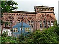
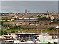
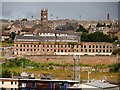
Dundee, Halleys Jute Mill (Wallace Craigie Works)
by David Dixon geograph for square NO4130 Built in 1835, Halleys Mill (Wallace Craigie Works) was once a prestigious icon... (more)
|
|
Former Jute Mill, Dundee
by David Dixon geograph for square NO4130 Built in 1835, Halleys Mill (Wallace Craigie Works) was once a prestigious icon... (more)
|
|
Former Barbour's mill, Hilden (8)
by Albert Bridge geograph for square J2865 The disused Hilden mill seen from the Tullynacross Road at Lambeg. The... (more)
Tags:
Barbour ThreadsX
Buildings at RiskX
top:Derelict, DisusedX
HildenX
Hilden MillX
top:IndustryX
Lagan ValleyX
former:MillX
top:Village, Rural SettlementX
|
|
Lennoxvale, Malone Road, Belfast (3)
by Albert Bridge for square J3372 See J3372 : Lennoxvale, Malone Road, Belfast (2). This at risk house which, incidentally, is where Sir William... (more)
|
|
Former Barbour's Mill, Hilden (7)
by Albert Bridge for square J2865 See J2865 : Former Barbour's Mill, Hilden (6). This view is from Bridge Street, Hilden about 15 minutes after... (more)
|
|
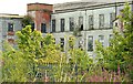
Former Barbour's Mill, Hilden (4)
by Albert Bridge geograph for square J2865 This is the best I can do to show something close to the whole site. The view... (more)
|
|
Barbour's Mill, Hilden
by Albert Bridge geograph for square J2865 Part of the premises, when still trading, seen from the Lagan towpath.
|
|
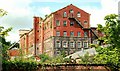
Former Barbour's Mill Hilden (3)
by Albert Bridge for square J2865 Category: Mill See J2865 : Former Barbour's Mill, Hilden (2). Part of the premises seen from the Hilden Road. Well fenced... (more)
|
|
Former Barbour's Mill, Hilden (2)
by Albert Bridge geograph for square J2865 Category: Mill (disused) .
See J2865 : Barbour Threads Factory Complex at Hilden and J2865 : Former Barbour's mill, Hilden. The closed mill seen from the towpath.... (more)
|
|
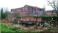
Former Barbour's mill, Hilden
by Albert Bridge geograph for square J2865 Category: Mill (closed) Barbours Hilden Mill opened in 1784 and closed in 2006. This was the site of... (more)
|
|
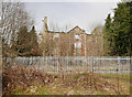
Former Stratton Lodge Hotel
by Craig Wallace geograph for square NH7146 Dating from the late 18th century, Stratton Lodge is a Category B listed... (more)
Tags:
Buildings at RiskX
listed building:Category BX
top:Derelict, DisusedX
Fire Damaged BuildingX
type:GeographX
top:Historic Sites and ArtefactsX
former:HotelX
top:Housing, DwellingsX
Metal FenceX
|
|
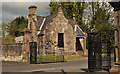
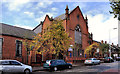
Inveraray Community Hall
by Gerald England geograph for square NN0908 A former public school built on the site of a temporary church (1871) by William... (more)
Tags:
Buildings at RiskX
listed building:Category AX
Category AX
building:Former SchoolX
type:GeographX
top:Public Buildings and SpacesX
School (Former)X
person:William MylneX
|
|
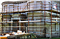
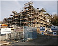
Restoration work, Fort William Primary School
by Craig Wallace geograph for square NN0973 This school was built circa 1876, designed by Alexander Ross. It has been... (more)
Tags:
Buildings at RiskX
listed building:Category BX
top:City, Town CentreX
top:Construction, DevelopmentX
top:Educational SitesX
place:Fort WilliamX
type:GeographX
top:Historic Sites and ArtefactsX
former:Primary SchoolX
Restoration WorkX
|

|
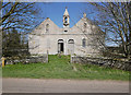
Cromdale Old Manse
by Craig Wallace geograph for square NJ0628 This house was built in 1834, as the manse for the adjacent Church of Scotland... (more)
Tags:
tree:BeechX
Buildings at RiskX
listed building:Category BX
place:CromdaleX
top:Historic Sites and ArtefactsX
top:Housing, DwellingsX
former:ManseX
top:Village, Rural SettlementX
|
|
Former Ewart Liddell factory, Donaghcloney (2012-1)
by Albert Bridge for square J1353 The remains of the former Ewart Liddell factory seen from Moygannon Lane. Now... (more)
Tags:
Buildings at RiskX
top:Derelict, DisusedX
DonaghcloneyX
FactoryX
former:FactoryX
top:IndustryX
top:Village, Rural SettlementX
|
|
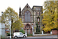
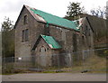
Former Holy Rosary church, Ballynafeigh, Belfast
by Albert Bridge geograph for square J3471 See J3471 : Holy Rosary Church (November 2005). The former Our lady of the Holy Rosary Roman... (more)
|
|
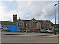
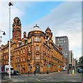
London Road Fire Station
by Gerald England geograph for square SJ8497 For about the last twenty years the building has been owned by Britannia Hotels... (more)
Tags:
date:1906X
date:1974X
date:1986X
date:2001X
former:Ambulance StationX
former:BankX
Buildings at RiskX
top:City, Town CentreX
former:Coroners CourtX
former:Fire StationX
former:Gas-Meter Testing StationX
Grade II(star) Listed BuildingX
top:Historic Sites and ArtefactsX
former:Police StationX
|
|
Transport House, Belfast (9)
by Albert Bridge geograph for square J3474 Transport House seen from beside the Salvation Army hostel in Victoria Street... (more)
|
|
Former Ulster Brewery, Belfast
by Albert Bridge geograph for square J3373 The remains of the former Ulster Brewery just off Sandy Row. Built in 1869 to a... (more)
|
|
Windmill stump, Crawfordsburn (2)
by Albert Bridge for square J4681 Another look at the old windmill stump last seen, in August 2007, in J4681 : Windmill stump, Crawfordsburn.... (more)
|
|
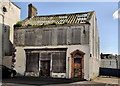
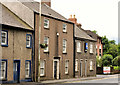
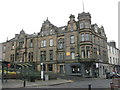
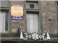
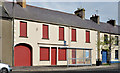
Liberal Club for sale, Hawick
by M J Richardson geograph for square NT5014 On the corner of High Street and Brougham Place. A memorial stone above the grey... (more)
Tags:
subject:BuildingX
Building at Risk
top:City, Town CentreX
Empty BuildingX
For Sale SignX
type:GeographX
place:HawickX
Liberal ClubX
top:LowlandsX
top:Roads, Road TransportX
place:Scottish BordersX
|
|
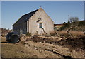
Former Reay Free Church, Shebster
by Craig Wallace for square ND0264 Dating from 1844. Last in use as a church in 1985. It is now a roofless shell.... (more)
Tags:
built:1844X
Buildings at RiskX
listed building:Category BX
former:ChurchX
type:Cross GridX
top:Derelict, DisusedX
top:Historic Sites and ArtefactsX
top:Religious SitesX
top:Village, Rural SettlementX
|
|
Former Strath Halladale Mission Church, Achiemore
by Craig Wallace geograph for square NC8957 The former Mission Church, next to the A897 road in Strath Halladale. Built in... (more)
Tags:
Buildings at RiskX
listed building:Category CX
former:ChurchX
type:GeographX
top:Historic Sites and ArtefactsX
HouseX
top:Housing, DwellingsX
top:Religious SitesX
Stained Glass WindowX
place:Strath HalladaleX
top:Village, Rural SettlementX
Wind TurbineX
|
|
|
Former Craig Dunain Hospital
by Craig Wallace geograph for square NH6343 The main building of the former Craig Dunain Psychiatric Hospital. The hospital... (more)
Tags:
Buildings at RiskX
listed building:Category BX
top:Construction, DevelopmentX
top:Derelict, DisusedX
Highland Council HERX
former:HospitalX
Housing DevelopmentX
top:Housing, DwellingsX
place:InvernessX
PanoramaX
top:Suburb, Urban FringeX
bucket:WideangleX
|
|
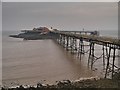
Birnbeck Pier
by David Dixon geograph for square ST3062 |
|
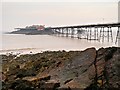
Birnbeck Island and Pier
by David Dixon geograph for square ST3062 The pier is almost derelict. It is closed to the public, only used by RNLI... (more)
|
|
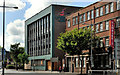
No 9 Donegall Quay, Belfast (2013)
by Albert Bridge geograph for square J3474 The vacant building facing Donegall Quay.
Tags:
place:BelfastX
Building at Risk
top:City, Town CentreX
top:Construction, DevelopmentX
top:Derelict, DisusedX
Development SiteX
Donegall QuayX
former:WarehouseX
|
|
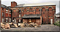
Former gate lodge, Ballymena
by Albert Bridge geograph for square D1003 The vacant and boarded up former gate lodge, facing the Cullybackey Road, at the... (more)
|
|
Former police barracks, Gilford
by Albert Bridge geograph for square J0648 A derelict (and fenced off) building in Dunbarton Street. On the at risk... (more)
|
|
John O' Groats Mill
by David Dixon geograph for square ND3773 Eighteenth century water-powered corn mill (LB1804... (more)
|
|
For Sale Notice, Hawick
by M J Richardson for square NT5014 The auction was clearly unsuccessful - this 'building at risk' still... (more)
Tags:
subject:BuildingX
Building at Risk
top:City, Town CentreX
type:Close LookX
For Sale SignX
place:HawickX
Liberal ClubX
top:LowlandsX
place:Scottish BordersX
|
|
Old Stromeferry Hotel
by Craig Wallace geograph for square NG8634 This hotel dates from 1874, but has been disused for a number of years. It was... (more)
Tags:
Buildings at RiskX
DerelictX
top:Derelict, DisusedX
Highland Council HERX
top:Historic Sites and ArtefactsX
former:HotelX
place:StromeferryX
top:Village, Rural SettlementX
|
|
Enderby House, at risk
by Stephen Craven geograph for square TQ3978 Because of its listed status, the building has been left standing as all around... (more)
|
|
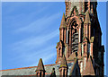
Former Carlisle memorial church, Belfast (4)
by Albert Bridge for square J3375 Part of the roof, tower and spire seen from Henry Place, Carlisle Circus. To... (more)
Tags:
place:BelfastX
Building at Risk
Church (Former)X
Church SpireX
Church TowerX
top:Derelict, DisusedX
|
|
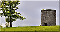
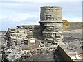
The old harbour lighthouse, Dunure
by Ann Cook geograph for square NS2516 This old lighthouse was built in 1811 and was deactivated in the 1850's.... (more)
|
|
Nos 119-121 Main Street, Dundrum
by Albert Bridge geograph for square J4036 Two vacant and boarded-up buildings on the western side of Main Street. Listed... (more)
|
|
Nos 18-20 Ferry Street, Portaferry
by Albert Bridge geograph for square J5950 Two derelict buildings in Ferry Street (middle in J5950 : Ferry Street, Portaferry (3)), on the official... (more)
|
|
Former Macrory Memorial Presbyterian church, Belfast
by Albert Bridge geograph for square J3375 The former Macrory Memorial Presbyterian church, in Duncairn Gardens, opposite... (more)
|
|
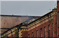
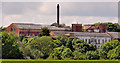
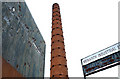
Former Monarch Laundry chimney, Belfast
by Albert Bridge for square J3273 Now closed and demolished, the Monarch Laundry, at the corner of the Donegall... (more)
|
|
Fortwilliam gates, Belfast (2)
by Albert Bridge for square J3477 Traditional Belfast embellishment of the top of this gate J3477 : Fortwilliam gates, Belfast (1) including... (more)
|