|
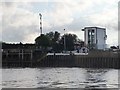
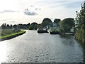
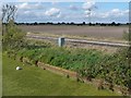
Entrance to Keadby Lock, west bank of the River Trent
by Christine Johnstone
geograph for square SE8311
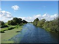
The eastern end of the Stainforth and Keadby Canal [part of the South Yorkshire... (more)
|
|
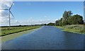
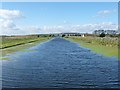
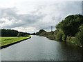
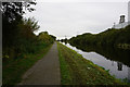
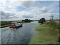
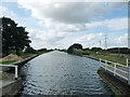
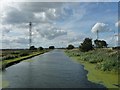
First bend west of Keadby, Stainforth & Keadby Canal
by Christine Johnstone
geograph for square SE8111
In the first five miles of the canal [west from Keadby] there are only four... (more)
|
|
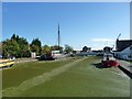
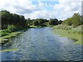
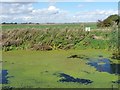
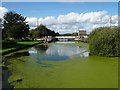
Green canal at Keadby
by Christine Johnstone
geograph for square SE8311
A complete cover of duckweed on the Stainforth & Keadby Canal. So thick, a... (more)
|
|
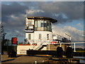
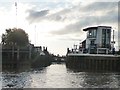
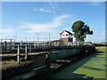
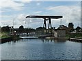
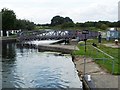
Control tower, Keadby Lock, Stainforth & Keadby Canal
by Christine Johnstone
geograph for square SE8311
At the junction of the canal and the tidal River Trent, hence the gates of... (more)
|
|
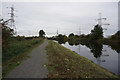
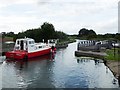
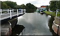
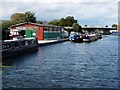
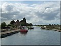
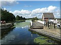
Keadby Lock, open to take a boat from the Trent
by Christine Johnstone
geograph for square SE8311
The eastern end of the Stainforth & Keadby Canal [South Yorkshire... (more)
|
|
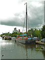
The Sea Cadets' boatspace at Keadby
by Christine Johnstone
geograph for square SE8211
On the north bank of the Stainforth & Keadby Canal. A base for canoeing.
|
|
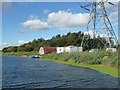
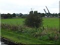
Stainforth & Keadby Canal - Keadby
by Chris Allen
geograph for square SE8311
In the background is Keadby Power Station - a gas fired combined cycle gas... (more)
|
|
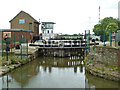
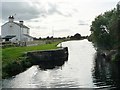
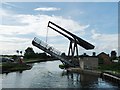
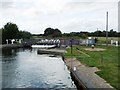
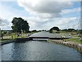
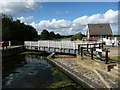
Stainforth & Keadby Canal - locks to River Trent
by Chris Allen
geograph for square SE8311
This lock has two sets of gates to allow for the canal or river being higher, as... (more)
|
|
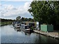
Boats moored outside the Thorne Cruising Club's basin
by Christine Johnstone
geograph for square SE6412
On the north bank of the Stainforth & Keadby Canal near Stainforth.
|
|
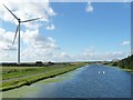
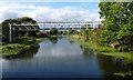
New bridge across the Stainforth & Keadby Canal
by Christine Johnstone
geograph for square SE8111
Erected to improve access during the construction of Keadby Wind Farm.
|
|
Stainforth & Keadby Canal at Keadby Wind Farm
by Christine Johnstone
geograph for square SE8111
The nearest turbine to the canal. Looking westwards.
|
|
The fixed section of track, Keadby Canal Crossing
by Christine Johnstone
geograph for square SE8211
Looking westwards from a boat on the Stainforth & Keadby Canal.
|
|
The sliding section of deck, Keadby Canal Crossing
by Christine Johnstone
geograph for square SE8211
Bisecting the angle of the fixed railway track and the Stainforth & Keadby Canal.
|
|
Stainforth & Keadby Canal at Stainforth East Ings
by Christine Johnstone
geograph for square SE6613
Looking westwards.
|
|
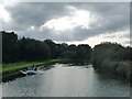
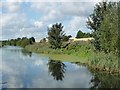
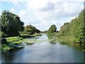
3 miles from Keadby and the second bend
by Christine Johnstone
geograph for square SE7910
Looking west on the Stainforth & Keadby Canal.
|
|
Stainforth & Keadby Canal towards Keadby Junction
by Ian S
geograph for square SE8211
|
|
Stainforth & Keadby Canal towards Keadby Junction
by Ian S
geograph for square SE8211
|
|
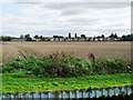
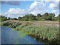
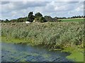
Stubble field, north-east of Stainforth
by Christine Johnstone
geograph for square SE6412
On the south bank of the Stainforth & Keadby Canal.
|
|
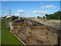
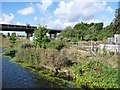
Vazon sliding railway bridge
by Chris Allen
geograph for square SE8211
This unique bridge was rebuilt in 2004 and carries a busy railway line over the... (more)
|
|
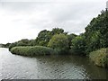
Winding hole, Stainforth & Keadby Canal
by Christine Johnstone
geograph for square SE6512
'Wind' as in breeze, not wool. Where boats that are longer than the... (more)
|
|
Pipe bridge, Stainforth & Keadby Canal, Thorne
by Christine Johnstone
geograph for square SE6812
Like the canalside houses in Marina View, unmapped in my 1997 canal guide, so... (more)
|
|
Diesel pump, Blue Water Marina, Thorne
by Christine Johnstone
geograph for square SE6912
On the north bank of the Stainforth & Keadby Canal. Most canal boats use... (more)
|
|
Boat passing through Moor's swingbridge
by Christine Johnstone
geograph for square SE7012
Carrying a minor road across the Stainforth & Keadby Canal. The maps and... (more)
|
|
Boat heading west on the Stainforth & Keadby Canal
by Christine Johnstone
geograph for square SE7212
East of Maud's swingbridge.
|
|
Crook O'Moor swingbridge, open to boaters
by Christine Johnstone
geograph for square SE7412
Looking westwards, on the Stainforth & Keadby Canal.
|
|
Railway line, north bank, Stainforth & Keadby Canal
by Christine Johnstone
geograph for square SE7711
Built in 1804, the canal came first, but made the railway surveyor's job easier.
|
|
Railway line, north bank, Stainforth & Keadby Canal
by Christine Johnstone
geograph for square SE7910
The box is at the side of the just-visible track. The canal [built in 1804] came... (more)
|
|
Northern canal bank, Stainforth & Keadby Canal
by Christine Johnstone
geograph for square SE7910
The North Soak Drain lies behind, which appears to be what the digger is working... (more)
|
|
Stainforth & Keadby Canal, west of Ealand Warpings
by Christine Johnstone
geograph for square SE8011
The towpath was 'not recommended' in my canal guide, published 1997.... (more)
|
|
The site of Dunstan Hill swingbridge
by Christine Johnstone
geograph for square SE6412
The bridge pivoted on the north [right] bank of the Stainforth & Keadby Canal.
|
|
Boating on the Stainforth & Keadby Canal
by Christine Johnstone
geograph for square SE6613
The inflatable is heading eastwards. The towpath, once 'not... (more)
|
|
Thorne Lock swingbridge opening to let a boat through
by Christine Johnstone
geograph for square SE6813
Above the top gates of the lock. carrying a minor road called Lock Hill over the... (more)
|
|
Tyler Wilson's premises in Thorne
by Christine Johnstone
geograph for square SE6812
Well-known builders of steel canal boats. On the west bank of the Stainforth... (more)
|
|
Wykewell lift bridge, opening for a boat
by Christine Johnstone
geograph for square SE6912
Carrying a minor road south from Thorne over the Stainforth & Keadby Canal.
|
|
Wykewell lift bridge, open for road users
by Christine Johnstone
geograph for square SE6912
The road barriers are still up. Carrying a minor road south from Thorne over the... (more)
|
|
Wykewell lift bridge, open for a boat
by Christine Johnstone
geograph for square SE6912
Carrying a road south from Thorne over the Stainforth & Keadby Canal.
|
|
Moor's swingbridge, opening for boaters
by Christine Johnstone
geograph for square SE7012
Carrying a minor road across the Stainforth & Keadby Canal. The maps and... (more)
|
|
Moor's swingbridge, ready to open for boaters
by Christine Johnstone
geograph for square SE7012
Carrying a minor road across the Stainforth & Keadby Canal. The maps and... (more)
|
|
Bend in the canal and the drains
by Christine Johnstone
geograph for square SE7012
From the right [north]: Stainforth & Keadby Canal, South Soak Drain [in... (more)
|
|
Maud's swingbridge, open for boaters
by Christine Johnstone
geograph for square SE7112
Carrying a minor road called Green Bank, over the Stainforth & Keadby Canal.
|
|
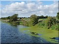
Not grass, but duckweed
by Christine Johnstone
geograph for square SE7212
The white ball is floating in the Stainforth & Keadby Canal.
|
|
Stainforth & Keadby Canal, looking westwards
by Christine Johnstone
geograph for square SE7212
The slender pylons carry the local supply across the canal.
|
|
Crook O'Moor swingbridge, closed to boaters
by Christine Johnstone
geograph for square SE7412
Carrying a minor access track across the Stainforth & Keadby Canal.
|
|
Godnow swingbridge, open for a boat
by Christine Johnstone
geograph for square SE7611
Carrying a minor road from Crowle over the Stainforth & Keadby Canal.... (more)
|
|
Godnow swingbridge, starting to open for a boat
by Christine Johnstone
geograph for square SE7611
Carrying a minor road from Crowle over the Stainforth & Keadby Canal.... (more)
|
|
Godnow swingbridge, Stainforth & Keadby Canal
by Christine Johnstone
geograph for square SE7611
The third of three ways out of Crowle, apparently.
|
|
Pit of former A161 swingbridge
by Christine Johnstone
geograph for square SE7810
Replaced by the high level bridge beyond. On the north bank of the Stainforth... (more)
|
|
North bank, Stainforth & Keadby Canal
by Christine Johnstone
geograph for square SE7810
Near the former Crowle Wharf.
|
|
Site of railway bridge, Stainforth & Keadby Canal
by Christine Johnstone
geograph for square SE7910
The 'narrows' mark the crossing point of the Isle of Axholme Light Railway.
|
|
Bonny Hale, Ealand
by Christine Johnstone
geograph for square SE7910
A building on the north bank of the Stainforth & Keadby Canal.
|