Public Tags
Other tags: Trig Point
subject:Trig Point
Showing images tagged with category:Trig Point tag.
|
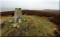
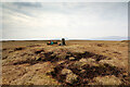
Passing Knitsley Fell trig. point
by Andy Waddington geograph for square NZ0935 Category: Trig Point The public footpath is shown on the map as passing a short way to the north of... (more)
|
|
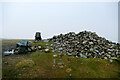
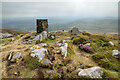
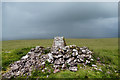
Moughton trig. point and pile of stones
by Andy Waddington geograph for square SD7871 Category: Trig Point One can only tell by the OS map whether a given heap of rocks is a cairn or a... (more)
|
|
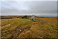
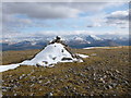
From cairn to trig point on Dun I
by Andy Waddington geograph for square NM2825 Category: Trig Point Dun I is a relatively easy ascent from the road north of the Abbey, but... (more)
Tags:
top:Air, Sky, WeatherX
top:CoastalX
top:Estuary, MarineX
type:GeographX
top:IslandsX
top:MoorlandX
category:Triangulation PillarX
category:Trig Point
top:UplandsX
|
|
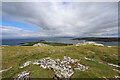
Cairn and trig point on High Pike
by Andy Waddington geograph for square NY3135 Category: Cairn The majority of the summits in the Caldbeck Fells are very rounded, boggy... (more)
|
|
The path northeast from Calf Top
by Andy Waddington geograph for square SD6685 Category: Public footpath The footpath continues northeast beyond the trig point (and summit - the... (more)
|
|
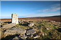
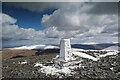
Looking past High Greygrits' trig point
by Andy Waddington geograph for square NY8708 Category: Trig Point Built of stone and cement, and with its white paint weathering away, the 522m... (more)
|
|
Tal y Fan trig point
by Andy Waddington geograph for square SH7272 Category: Trig Point The trig point on Tal y Fan, at 610m is just barely above the two thousand foot... (more)
|
|
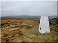
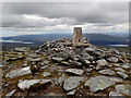
Dodd Fell Trig Point
by Andy Waddington geograph for square SD8484 Category: Trig Point There's little trace of the white paint which would have once adorned the... (more)
|
|
Trig point, Ben Hope
by Andy Waddington geograph for square NC4750 Category: Trig Point Although one of Scotland's lower Munros (only 927m) there's nothing of... (more)
|
|
Icy trig point on Skiddaw
by Andy Waddington geograph for square NY2629 Category: Summit It had been wet at home, and not that cold, so we weren't quite expecting... (more)
Tags:
type:GeographX
top:MoorlandX
top:PathsX
top:Rocks, Scree, CliffsX
top:Sport, LeisureX
category:SummitX
category:Trig Point
top:UplandsX
|
|
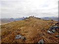
Summit of Beinn Bhàn
by Andy Waddington geograph for square NN1485 Category: Cairn Corbetts have a reputation for good views, partly based on their separation from... (more)
Tags:
top:Barren PlateauxX
category:CairnX
CorbettX
top:Country EstatesX
category:SummitX
category:Trig Point
top:UplandsX
|
|
North north west over Nettle Hill
by Andy Waddington geograph for square NY7107 Category: Trig Point A couple of minutes earlier, whilst munching sandwiches, we'd had a good... (more)
|
|
Beinn Bhuidhe summit from the west
by Andy Waddington geograph for square NM8296 Category: Summit Although "only" a Corbett at 855m, Beinn Bhuidhe is a huge broad-based... (more)
|