|
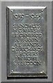
Tib Street War Memorial Tablet (4)
by Gerald England
for square SJ8498
On a wall on Tib Street SJ8498 : Tib Street are tablets transferred from the premises... ( more) |
|
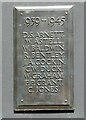
Tib Street War Memorial Tablet (3)
by Gerald England
for square SJ8498
On a wall on Tib Street SJ8498 : Tib Street are tablets transferred from the premises... ( more) |
|
Tib Street War Memorial Tablet (2)
by Gerald England
for square SJ8498
On a wall on Tib Street SJ8498 : Tib Street are tablets transferred from the premises... ( more) |
|
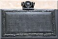
Tib Street War Memorial Tablet (1)
by Gerald England
for square SJ8498
On a wall on Tib Street SJ8498 : Tib Street are tablets transferred from the premises... ( more) |
|
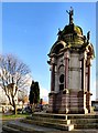
Kay Monument
by Gerald England
for square SD8010
|
|
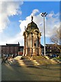
Kay Monument
by Gerald England
geograph for square SD8010
|
|
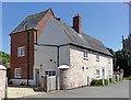
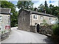
Old Hall Farmhouse, Thrussington
by Alan Murray-Rust
geograph for square SK6415
The colour-washed section of the house dates from c.1700, the taller wing to the... (more)
|
|
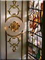
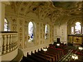
Church of St Michael and All Angels, Witley
by Alan Murray-Rust
for square SO7664
Detail of the applied papier mache decoration and one of the stained glass windows.
|
|
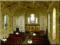
Church of St Michael and All Angels, Witley
by Alan Murray-Rust
for square SO7664
View from the gallery showing the windows on the north side of the church.
|
|
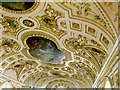
Church of St Michael and All Angels, Witley
by Alan Murray-Rust
for square SO7664
The ceiling. The main panel shows the Ascension of Christ.
|
|
Church of St Michael and All Angels, Witley
by Alan Murray-Rust
for square SO7664
View from the gallery towards the altar.
|
|
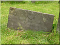
Belvoir Angel headstone, Upper Broughton Churchyard
by Alan Murray-Rust
for square SK6826
Thomas Hemsley d.1747. Either a small stone or very deeply sunken. Listed Grade II.
|
|
Ridge End House
by Stephen Craven
for square SE0661
This stone house of 1747 at the entrance to Parcevall Hall estate predates the... (more)
|
|
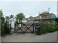
Building site at The Green, east of Cark
by Christine Johnstone
geograph for square SD3676
A 1747 porch frame still stands, but its farmhouse has gone. The barn is being converted.
|
|
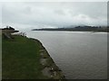
The tidal River Nith downstream of Glencaple Quay
by Christine Johnstone
geograph for square NX9968
Looking south towards the Solway Firth. Glencaple was developed as a port for... (more)
|
|
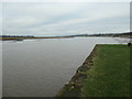
The tidal River Nith upstream from Glencaple Quay
by Christine Johnstone
geograph for square NX9968
Looking north towards Dumfries. Glencaple was developed as a port for Dumfries,... (more)
|
|
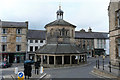
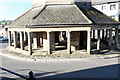
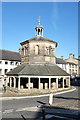
The Market Cross
by Bob Harvey
geograph for square NZ0516
One of the most famous sites in Barnard Castle, also known as the Butter Cross.... (more)
|
|
Belvoir Angel headstone, Nether Broughton Churchyard
by Alan Murray-Rust
for square SK6926
Thomas Welch Clarke son John & Elizabeth Clarke d.1747 aged 0.
|
|
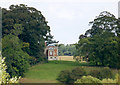
Burton Chateau seen from Littleborough
by Alan Murray-Rust
for square SK8283
18th century folly in the form of a classical temple, built in 1747 by James... (more)
|
|
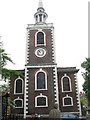
St Mary, Rotherhithe - west tower
by Stephen Craven
for square TQ3579
Category: Church tower
The tower of St Mary's was built in 1747 and the spire rebuilt in 1861... (more)
|
|
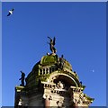
A pigeon sits by the feet of Fame while a gull flies over and the moon lurks in the background
by Gerald England
for square SD8010
|
|
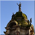
Kay Monument Dome
by Gerald England
for square SD8010
|
|
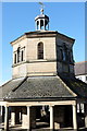
The Market cross: lower storey
by Bob Harvey
for square NZ0516
|
|
The Market cross upper storey
by Bob Harvey
for square NZ0516
|
|
The Market cross in the sunshine
by Bob Harvey
geograph for square NZ0516
|
|
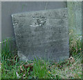
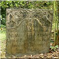
Gravestone of William Addis, d.1741, Wollaton churchyard
by Alan Murray-Rust
for square SK5239
A fine specimen of a mid-18th century slate gravestone. The military... (more)
|