Public Tags
Tag: Dry·Waterfall
Showing images tagged with Dry Waterfall tag.
|
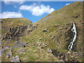
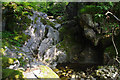
Dry and wet waterfalls, Scordale
by Karl and Ali geograph for square NY7623 There are actually two falls here - a dry one on the left and the cascade on the... (more)
Tags:
BeckX
rock:DoleriteX
Dry Waterfall
top:Geological InterestX
top:MoorlandX
top:Rivers, Streams, DrainageX
top:Rocks, Scree, CliffsX
top:UplandsX
WaterfallX
|
|
Dry waterfall, South Barkin Gill
by Karl and Ali geograph for square SD6684 There are several rock steps within the confines of this impressive limestone... (more)
|
|
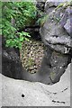
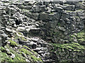
Dry waterfall at the bottom of the Consistone Dib path
by Chris Holifield geograph for square SD9867 On some maps this area is called Gurling Trough
Tags:
Dry ValleyX
Dry WatercourseX
Dry Waterfall
type:GeographX
top:Geological InterestX
subject:Limestone FeatureX
top:Rocks, Scree, CliffsX
|
|
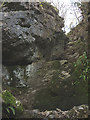
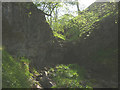
Upper Easegill Kirk
by Dave Dunford geograph for square SD6680 The dry waterfall in Upper Easegill Kirk from below. A dead sheep (out of view... (more)
|
|
Dry waterfall, Caseker Gill
by Karl and Ali geograph for square SD9874 Typically, in a limestone area, the water is underground (in this case, nearby Dow Cave).
Tags:
Dry Stream BedX
Dry Waterfall
type:GeographX
top:Geological InterestX
top:Rivers, Streams, DrainageX
top:Rocks, Scree, CliffsX
top:UplandsX
|
|
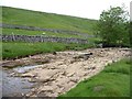
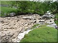
River Wharfe disappearing under a dry waterfall
by Christine Johnstone geograph for square SD8880 The water is going under the falls [through cracks in the limestone], rather... (more)
Tags:
Dry River BedX
Dry Waterfall
place:LangstrothdaleX
Limestone FeatureX
top:Rivers, Streams, DrainageX
river:WharfeX
|
|
Dry waterfall on the River Wharfe
by Christine Johnstone geograph for square SD8880 The water is going under the falls [through cracks in the limestone], rather... (more)
Tags:
Dry River BedX
Dry Waterfall
place:LangstrothdaleX
Limestone FeatureX
top:Rivers, Streams, DrainageX
river:WharfeX
|
|
Oven Mouth
by Stephen Craven geograph for square NY8602 A deep, steep clough on the side of Whitsundale, possibly the site of a seasonal... (more)
|
|
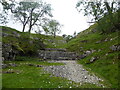
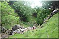
Dry waterfall, Ease Gill
by Ian Taylor geograph for square SD6680 All the water in the beck is currently flowing underground.
|
|
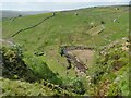
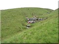
Sheep on High Thorn Haw
by Christine Johnstone geograph for square SD8779 Posing on what appears to be a dry waterfall, just east of the footpath to... (more)
|
|
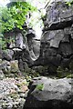
Upper Easegill Kirk
by Dave Dunford for square SD6680 The dry waterfall in Easegill Kirk from above.
Tags:
Dry Waterfall
Limestone GorgeX
top:Rivers, Streams, DrainageX
top:Rocks, Scree, CliffsX
place:Yorkshire DalesX
|
|
The River Wharfe, below a dry waterfall
by Christine Johnstone geograph for square SD8880 The water is going under the falls [through cracks in the limestone], rather... (more)
Tags:
Dry Waterfall
top:Geological InterestX
place:LangstrothdaleX
Limestone FeatureX
RiverbankX
top:Rivers, Streams, DrainageX
Riverside TreesX
river:WharfeX
|
|
Kinder Downfall
by Stephen Burton geograph for square SK0888 On this particular day no water was falling over the edge of the downfall.
|
|
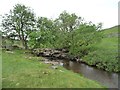
Above Lower Easegill Kirk
by Dave Dunford geograph for square SD6679 Between Upper and Lower Easegill Kirk.
|