Public Tags
Tag: Farmhouse·Access·Road
Showing images tagged with Farmhouse Access Road tag.
|
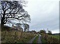
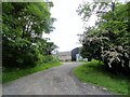
Looking up to Low Bradley
by Robert Graham geograph for square NZ1253 View of the farmhouse from the access road to Leadgate.
Tags:
top:Farm, Fishery, Market GardeningX
subject:FarmhouseX
FarmhouseX
Farmhouse Access Road
type:GeographX
top:LowlandsX
top:Roads, Road TransportX
Winter TreesX
|
|
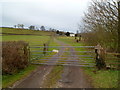
Access lane to Salisbury Farmhouse, St Brides Netherwent
by Jaggery geograph for square ST4288 Viewed from St Brides Road. The yellow sign on the gate states that a security... (more)
|
|
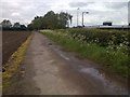
Track from Out Woods Farm
by Mick Garratt geograph for square SK5117 |
|
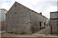
Buildings at Jerusalem Farm
by Roger Templeman geograph for square NY6519 There is an OS benchmark NY6519 : Benchmark on building at Jerusalem Farm on the large quoin on the near corner of... (more)
|
|
Ashes House farm
by Robert Graham geograph for square NZ0636 Farm south of Wolsingham in Weardale. Looking along the entrance road.
|